Sold2018Faden Quartz~Kharan PaksitanItem: Faden Quartz~Kharan Paksitan Treatment: Natural Material: Quartz Weight: 24 Gram Dimensions: 55x34x12 mm Origin: Pakistan No Reserve: This lot starts at $1 and has no reserve as a courtesy so thSee Sold Price
Sold2017William Faden, rare Revolutionary War Map of NYWilliam Faden, rare Revolutionary War Map of NY, William Faden (British, 1749-1836), "A Plan of the Operations of the Kings Army under the Command of General Sr. William Howe, K.B. in New York and EasSee Sold Price
Sold2022Faden Map of the Battle of Hobkirk's Kill, Revolutionary War, 1781FADEN, William (1749 – 1836). Sketch of the Battle of Hobkirks Hill, near Camden on the 25th April, 1781. Engraved map. London: Faden, Aug. 1, 1783. 21 3/4" x 15 1/8" sheet. This RevolutionarySee Sold Price
Sold2017William Faden 1796 Map Eastern US, North AmericaFaden, William (BRITISH, 1749-1836); Map of the Eastern United States, North American with British Territories and Those of Spain according to the Treaty of 1784 (from a larger atlas), 1796; handcolorSee Sold Price
Sold2022Faden - United States of North America, MapWilliam Faden, (1749-1836), The United States of North America: with the British territories and those of Spain..., London, 1796, "Published as the Act directs, Feby. 11, 1796, by Willm. Faden, GeograSee Sold Price
Sold2022Faden Map of the Plan of the Attack of the Forts Clinton & Montgomery with beautiful original handFADEN, William (1749-1836). Plan of the Attack of the Forts Clinton & Montgomery upon Hudsons River which were Stormed by His Majesty's Forces under the Command of Sir Henry Clinton, 6th of Octr. 1777See Sold Price
Sold2022(QUEBEC.) William Faden. Plan of the City and Environs of Quebec with Its Siege and Blockade by the(QUEBEC.) William Faden. Plan of the City and Environs of Quebec with Its Siege and Blockade by the Americans. Large engraved plan of American positions during their failed raid on the British stronghSee Sold Price
Sold2017Faden & Stedman: Antique Map, Seige of Savannah, 1794Title/Content of Map: Seige of Savannah Date Printed: 1794 Cartographer: Faden & StedmanMaterial/Medium: Engraving Size: 28 1/2" x 22 1/2" Original engraving from Stedman's History of the American WarSee Sold Price
Sold2024Two Maps of the United States by William Faden (London, 1785 and 1796)Two Maps of the United States by William Faden (London, 1785 and 1796) Two hand-colored maps engraved by William Faden (British, 1749-1836), London, 1785 and 1796. Titled "The United States of North ASee Sold Price
Sold2021Nouvelle Carte de La Suisse les trieze cantons. FADEN.TITLE/CONTENT OF MAP: 'Nouvelle Carte de La Suisse dans laquelle sont exactement distingués les trieze cantons, leurs alliés, et leurs sujets' The top image on the right hand side shows the entire mSee Sold Price
Sold2024Faden Revolutionary War Map of SaratogaFADEN, William (1749-1836). Plan of the Position which the Army under Lt. Genl. Burgoine took at Saratoga on the 10th of September 1777, and in which it remained till the Convention was signed. EngravSee Sold Price
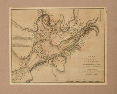
Sold2024Faden Revolutionary War Map of HubertonFADEN, William (1749-1836). Plan of the action at Huberton under Brigadier Genl. Frazer, supported by Major Genl. Reidesel, on the 7th July 1777. Drawn by P. Gerlach Deputy Quarter Master General. EngSee Sold Price
Sold2023A map of America or the New World… FADEN / PALMER. British N California 1797Title: A map of America or the New World… FADEN / PALMER. British N California 1797Description: A map of America or the New World wherein are introduced all the known parts of the Western HemisphereSee Sold Price
Sold2018India.- Faden (William) A Map of the Peninsula of IndiaIndia.- Faden (William) A Map of the Peninsula of India from the 19th Degree North Latitude to Cape Comorin, impressive two sheet map of the Indian subcontinent, extending from Bombay and Aurungabad,See Sold Price
Sold20211780 Faden Map of American Revolutionary War Battle inTitle: 1780 Faden Map of American Revolutionary War Battle in Vermont -- Plan of the Action at Huberton Under Brigadier Genl. Frazer, Supported by Major Genl. Reidesel, on the 7th July 1777 CartographSee Sold Price
Sold2023A Chart of the Gulf of Florida / W. Faden / Charing Cross 1794, 24" X 17 1/2".A Chart of the Gulf of Florida / W. Faden / Charing Cross 1794, 24" X 17 1/2".See Sold Price
Sold2019William Faden "Map of the Peninsula of India…" 1792**Originally Listed At $300** William Faden (British, 1749-1836), "A Map of the Peninsula of India from the 19th Degree North Latitude to Cape Comorin, MDCCXCII" - published in London, 1792. An antiquSee Sold Price
Sold2024Europe exhibiting its principal states &c. First French Empire. FADEN 1791 mapTITLE/CONTENT OF MAP: 'Europe exhibiting its principal states &c' DATE PRINTED: 1791 IMAGE SIZE: Approx 54.5 x 69.5cm, 21.5 x 27.25 inches (Large); Please note that this is a folding map. TYPE: LargeSee Sold Price
Sold20241795 Chart of Jersey and Guernsey, Sark, Herm and Alderney, FadenTitle/Content of Map: 1795 Chart of Jersey and Guernsey, Sark, Herm and Alderney, Faden Date Printed: 1795 Cartographer: William Faden Material/Medium: Engraving Size: 23.5 x 33" Beautiful double-pageSee Sold Price
Sold20222 Framed 18th C. Faden Maps - Greece & Denmark**Originally Listed At $200** Cartographer: William Faden (British, 1749-1836). Engraver: William Palmer (British, 1735-1812). "Graecie Antiquae et Aegaei Maris Tabula" Published by William Faden JanuSee Sold Price
Sold2019William Faden (1749-1836), "Die Vereinigten Staaten vonWilliam Faden (1749-1836), "Die Vereinigten Staaten von Nord America," 1783,hand colored, H. - 8 in., W. - 10 in.See Sold Price
Sold2018Natural Faden Quartz CrystalsTitle: Natural Faden Quartz Crystals Maker: 155 Grams Origin: Pakistan Materials: Crystal Size: ***** Description: Natural Reserve: $50.00 Please note that this lot has a confidential reserve. When yoSee Sold Price
Sold2023MAP ENGRAVING OF THE CARIBBEAN ISLANDS BY WM. FADEN.MAP ENGRAVING OF THE CARIBBEAN ISLANDS BY WM. FADEN. English, 19th Century. "Chart of the Antilles".See Sold Price
Sold20241798 Faden Map of Africa -- Africa According to the Latest ExplorationsTitle: 1798 Faden Map of Africa -- Africa According to the Latest Explorations Cartographer: W Faden Year / Place: 1798, London Map Dimension (in.): 3.9 X 4.4 in. This is a very nice compact map of AfSee Sold Price
Jul 08Hermann Historica GmbHEleven Near Eastern bronze cloak pins, late 2nd - early 1st millennium B.C.€240
Jun 23Schilb Antiquarian Rare Books1901 Treasury of Pashto Ganj e Pakhtu Roos Keppel Afghanistan Folklore Pakistan$24(2 bids)
6 days LeftGems Auction5.00 Ct Natural Rhodolite Garnet & Pakistan Peridot Excellent Jewellery Set$32(6 bids)
Jul 02Rob Michiels AuctionsA varied collection of jewellery and accessories, Afghanistan, India, Pakistan, and Yemen, 19th C.€300
5 days LeftJasper521806 Cary Map of India, Pakistan and Sri Lanka -- A New Map of Hindoostan, from the Latest$70
Jul 03Rob Michiels AuctionsA varied collection of four terracotta animal sculptures and two bowls, Indus Valley, Iran, Pakistan€1,600
1 day LeftTreasure of Gems & JewelryNatural Green Peridot 3.09 Ct. Cushion Shape 10.1 x 7 Mm. Gemstone Unheated From Pakistan$1(1 bid)