Sold2021FOLIO OF ATLAS TO ACCOMPANY THE OFFICIAL RECORDS OF THEFOLIO OF ATLAS TO ACCOMPANY THE OFFICIAL RECORDS OF THE UNION AND CONFEDERATE ARMIES BY JULIUS BIENPublished Under the Direction of the Hons. Redfield Proctor, Stephen B. Elkins, and Daniel S. Lamont,See Sold Price
2022MAP antique SAVANNAH GA GENERAL SHERMAN ARMY CIVIL WAR 1864 OPERATIONS CAMPAIGNOriginal Lithograph Plate LXX (70) of the 175 Plates of The Official Folio Historical Record of The Official Atlas to Accompany the Official Records of the Union and Confederate Armies, Ordered by ActSee Sold Price
Sold2016Atlas to Accompany the Official Records of the UnionAtlas to Accompany the Official Records of the Union and Confederate Armies 1861-1865, Part III, published between 1891-1895, 15 3/4" x 18 1/4", having brown swirling marbleized boards, leather cornerSee Sold Price
Sold2017Civil War PrintPair of early post Civil War Military prints, commissioned by Congress C. 1896. Artist Julius Ien & Co., N.Y.. Comes with "Atlas To Accompany The Official Records Of The Union And Confederate Armies".See Sold Price
Sold2016Chancellorsville Campaign and DranesvilleMap: Chancellorsville Campaign and Dranesville, Atlas to Accompany the Official Records of the Union and Confederate Armies Maker: The United States War Department Printer: Julius Bien & Company, WashSee Sold Price
Sold202319th century. A clean original Julius & Bien CO, NY map of Missouri, 1865. Plate CLII. Atlas to19th century. A clean original Julius & Bien CO, NY map of Missouri, 1865. Plate CLII. Atlas to accompany the official records of the Union and Confederate Armies, 1861-1865. Measures 29.5 x 19 inchesSee Sold Price
Sold202319th century. A clean original Julius & Bien CO, NY map of the Campaign of the Army of West19th century. A clean original Julius & Bien CO, NY map of the Campaign of the Army of West Mississippi, 1865. Plate CX. Atlas to accompany the official records of the Union and Confederate Armies, 18See Sold Price
Sold20182 Volumes Official Records Atlas of the Civil War2 Volumes Official Records Atlas of the Civil War, leather, complete 75 plates.-- Dimensions: ---See Sold Price
Sold2021Two 19th Century American MapsA map that describes the Atlanta Campaign from the Atlas of the official records of the Union and the Confederate Armies, published by Julius Bein and Co. And an Dutch map that depicts Dakota, Iowa, NSee Sold Price
Sold2015U.S. War Department Atlas...Cumberland Gap, TennesseeU.S. War Department. Atlas of the Official Records. Army of the Cumberland, Cumberland Gap, Tennessee... Map of the Environs of Petersburg, Virginia.Note: Atlas Plate no. 118Dimensions 16X26 1/2"Inv.5See Sold Price
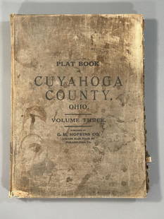
Sold2023Plat Book of the City of Cleveland, Ohio, Volume Three 1914Philadelphia: G.M. Hopkins, 1914. This atlas was issued as Volume 3 of the title Plat-book of the city of Cleveland, Ohio and suburbs, complete in two volumes from official records, private plans andSee Sold Price
Sold2023"Outline & Index Map of New York City" New York: E. Robinson Co., 1885"Outline & Index Map of New York City" New York: E. Robinson Co., 1885. From Robinson's Atlas of the City of New York: embracing all territory within its corporate limits from official records, privatSee Sold Price
Sold2022191 2 Preble County Ohio AtlasFolio size in embossed black buckram boards with calf spine entitled Plat Book of Preble County Ohio Compiled From County Records and Actual Surveys., Publishd by Northwest Publishing Co. Des Mones, ISee Sold Price
2023Vancouver's A Voyage of Discovery to the North Pacific Ocean - 6 Octavo Volumes, 1 Folio AtlasGeorge Vancouver's A Voyage of Discovery to the North Pacific Ocean, and Round the World; in which the Coast of North-west America has been carefully examined and accurately surveyed undertaken by HisSee Sold Price
Sold2018Hayden Folio Atlas of Colorado 1877Heading: Author: Hayden, Ferdinand V. Title: Geological and Geographical Atlas of Colorado and Portions of Adjacent Territory Place Published: [n.p.] Publisher:Julius Bien Date Published: 18See Sold Price
Sold2022US Civil War of Rebellion Official Records 114 Vol114 hardcover books from the "War of Rebellion: Official Records of The Union and Confederate Armies" four-part series published by Broadfoot Publishing Company and printed by Historical Times, Inc. iSee Sold Price
Sold2019Hayden Folio Atlas of Colorado 1877Heading: Author: Hayden, Ferdinand V. Title: Geological and Geographical Atlas of Colorado and Portions of Adjacent Territory Place Published: [n.p.] Publisher:Julius Bien Date Published: 18See Sold Price
Sold2020Stenciled Blue Painted Trunk, WWI US Official RecordsStenciled Blue Painted Trunk, WWI US Official Records. This trunk was found in upstate NY in an estate. The stencil reads Official Records and Assistant Quartermaster.Condition: Excellent, Please callSee Sold Price
Sold2024OFFICIAL RECORDS OF THE UNION AND CONFEDERATE NAVIES IN THE WAR OF THE REBELLION, 1894, 24 VOLUMES1894. Washington, D.C. U.S. Government Printing Office. 24 volumes total in this set, in Series One and Two. Series One is missing volume 10. All volumes are in Very Good condition. Series Two only haSee Sold Price
Sold2018Prison Log, Walla Walla Official RecordPrison Log, Walla Walla Official Handwritten Records. Late 19th to early 20th century. Approximately 6" x 4" x .25". Provenance: Estate of Russell Johanson, Ravenna Rare Books, Seattle, WA. We ship moSee Sold Price
Sold2020[ATLASES]. Lot of 3 Folio Atlas sold together[ATLASES]. Lot of 3 Folio Atlas sold together. Including: Black’s General Atlas of The World. Edinburgh:Adam and Charles Black. 1888. ** Department of The Interior. Atlas of Canada. Ottawa, 191See Sold Price
Sold2018Official Records of the Armies in the Civil WarHeading: (Civil War) Author: Title: The War of the Rebellion: A Compilation of the Official Records of the Union and Confederate Armies, Series I - eleven volumes Place Published: Washington PublisheSee Sold Price
Sold2023New England, New York, early official records.New England, New York, early official records. - [ANON.] Journal of the Legislative Council of the Colony of New York. Began the 9th Day of April, 1691; and Ended the 27 of September, 1743. Albany: 18See Sold Price
Sold2017Official Records of The Union And Confederate NaviesOfficial records of the Union and Confederate Navies in the War of The Rebellion - Series II, Volume 1, 2, 3, United States, Department of the Navy. White, Harry Kidder (editor), United States, DepartSee Sold Price
Jun 08Simpson Galleries, LLC.JULIUS BIEN (1826-1909) AN AMERICAN CIVIL WAR RECONNAISSANCE MAP, "Map of Texas and Part of New$100
Jun 01Trillium Antique Prints & Rare BooksCollot's A Journey in North America - Atlas Volume with 36 Maps$200
Jun 08Early American History Auctions1828 GEORGE BIBB Treasury Secretary Autograph Document Signed Re: the Theft of a Slave and Her Child$400
Jun 08Early American History Auctions1784 Connecticut Acts and Laws Raising Taxes to Pay Off United States Revolutionary War Debt$550
5 days LeftJasper52Argentine Republic, Chile, Paraguay & Uruguay. South America. STANFORD 1904 map$60
5 days LeftJasper52Colombia, Ecuador & Peru. Andean States. Panama canal. 71x52cm STANFORD 1904 map$60
Featured5 days LeftJasper52Argentine Republic, Chile, Paraguay & Uruguay. South America. STANFORD 1894 map$80
5 days LeftJasper52Argentine Republic, Chile, Paraguay & Uruguay. South America. STANFORD 1896 map$80
5 days LeftJasper52Amér. Sep. Partie de l'Amérique Russe #14 Colombia profile VANDERMAELEN 1827 map$55
5 days LeftJasper52Amér Mér Colombie & Brésil 9 Peru Colombia Amazonas Brazil VANDERMAELEN 1827 map$70
5 days LeftJasper52Amér Mér. Colombie #5 Eastern Colombia. NW Amazonas Brazil VANDERMAELEN 1827 map$100
5 days LeftJasper52Amér. Mér. Colombie #2. Western Venezuela & NE Colombia. VANDERMAELEN 1827 map$100
5 days LeftJasper52Amér. Mér. Colombie #4. SW Colombia & northern Ecuador. VANDERMAELEN 1827 map$120
5 days LeftJasper52Amér. Mér. Colombie #1. Panama & northwestern Colombia. VANDERMAELEN 1827 map$120
Will Sullivan Auction Co.Circa 1980 Winchester Xpert Model 96 (26.5" M/IC), 20 Ga., O/U, SN - K249864$700(16 bids)


![Hayden Folio Atlas of Colorado 1877: Heading: Author: Hayden, Ferdinand V. Title: Geological and Geographical Atlas of Colorado and Portions of Adjacent Territory Place Published: [n.p.] Publisher:Julius Bien Date Published: 18](https://p1.liveauctioneers.com/642/125890/64050862_1_x.jpg?height=310&quality=70&version=1533827242)

![Hayden Folio Atlas of Colorado 1877: Heading: Author: Hayden, Ferdinand V. Title: Geological and Geographical Atlas of Colorado and Portions of Adjacent Territory Place Published: [n.p.] Publisher:Julius Bien Date Published: 18](https://p1.liveauctioneers.com/642/147216/74382392_1_x.jpg?height=310&quality=70&version=1565044891)


![[ATLASES]. Lot of 3 Folio Atlas sold together: [ATLASES]. Lot of 3 Folio Atlas sold together. Including: Black’s General Atlas of The World. Edinburgh:Adam and Charles Black. 1888. ** Department of The Interior. Atlas of Canada. Ottawa, 191](https://p1.liveauctioneers.com/1124/187577/94368834_1_x.jpg?height=310&quality=70&version=1607095126)

![New England, New York, early official records.: New England, New York, early official records. - [ANON.] Journal of the Legislative Council of the Colony of New York. Began the 9th Day of April, 1691; and Ended the 27 of September, 1743. Albany: 18](https://p1.liveauctioneers.com/3975/301526/160693996_1_x.jpg?height=310&quality=70&version=1694182765)


