Sold2022Framed Chesapeake Bay MD/VA Nautical ChartFramed nautical chart / map of the Chesapeake Bay, between the Maryland and Virginia border. Map is in excellent condition Paper backing is torn on back of frame and lower right corner of frame has seSee Sold Price
Sold2022Framed Maryland Chesapeake Bay Chart / MapNOAA Chart 12273, Maryland Chesapeake Bay Sandy Point to Susquehanna River. Professionally sealed in frame. Excellent condition. 41"x36.5".See Sold Price
Sold2022Framed Corpus Christi Bay Nautical ChartCorpus Christi nautical chart, 4th ed., dated "May / 10" marked by the National Oceanic and Atmospheric Administration (NOAA), United States Coast and Geodetic Survey height 39 in. x width 49See Sold Price
Sold2023NAUTICAL CHART / CHESAPEAKE BAY COVE POINT TO SANDY POINTDescription: United States – East Coast Maryland. NAUTICAL CHART / CHESAPEAKE BAY COVE POINT TO SANDY POINT. Published at Washington D.C/ US Department of Commerce National Oceanic and AtmospheSee Sold Price
Sold2021Eight Framed New England Nautical Charts.Largest frame 49 x 36 inches. This item is not eligible for in house shipping. Buyer will be responsible for arranging pickup or delivery.See Sold Price
Sold20211921 with 1943 Revision of Hiroshima Bay Nautical ChartTitle: 1921 with 1943 Revision of Hiroshima Bay Nautical Chart -- Japan Naikai or Inland Sea Aki Nada Hiroshima Wan Cartographer: US Hydrographic Office Year / Place: 1921 with 1943 Revision, WashingtSee Sold Price
Sold2020Rhode Map Narragansett Bay Nautical Chart MapRhode Map Narragansett Bay Nautical Chart Map. Used condition. 49 1/2" tall x 37" wide.See Sold Price
Sold2022Mary Stokes Lighthouses of Chesapeake Bay PrintMap of the Lighthouses of the Chesapeake Bay framed art print. 1994. Artist Mary Jane Thomas Stokes. Professionally framed and in excellent condition.See Sold Price
Sold2021George Eldridge, Large Chart of Chesapeake Bay 1868George Eldridge / G. W. Boynton, Sc., ELDRIDGEÕS CHART OF CHESAPEAKE BAY, JAMES, YORK, RAPPAHANNOCK AND POTOMAC RIVERS. Compiled from the latest surveys by GEORGE ELDRIDGE, HYDROGRAPHER. Boston: S. TSee Sold Price
Sold2022Vintage RR map of Maryland & Delaware, 1850Excellent 1850 map of Maryland and Delaware with a chart of Chesapeake Bay Steamboat Routes. Published a decade before the Civil War and during an explosion in the country's railroad routes, the map aSee Sold Price
Sold20224 Advertising Items1 Chesapeake Bay retriever framed & matted 14"W x 17"T, 1 Call Of The Wild with grandfather & grandson fishing calendar 12"W x 16"T, 1 Goodyear tires calendar 1950 with duck & lake scene advertising MSee Sold Price
Sold2023Nautical Chart: FROM PENOBSCOT BAY TO KENNEBEC ENTRANCEDescription: FROM PENOBSCOT BAY TO KENNEBEC ENTRANCE Measurement approximate: 40 x 31 InchesMaterial: PaperSee Sold Price
Sold2020MORTIER, PIERRE. Carte Particuliere de Virginie,MORTIER, PIERRE. Carte Particuliere de Virginie, Maryland, Pennsilvanie, la Nouvelle Jarsey Orient et Occidentale. Large double-page engraved chart of the Chesapeake Bay. 25x37 inches sheet size, wideSee Sold Price
Sold2023Chart from Penobscot Bay to KennebecNautical chart from Penobscot Bay to the Kennebec river on the coast of Maine. Showing St. Georges, Cushing, Waldoboro, Damariscotta Whitehead, Marshalls Point, Thomaston, Bath, Etc. A Navigator has pSee Sold Price
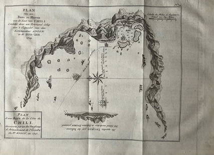
Sold2022Nautical chart of a unidentified bay in Chile. By the English pirate Anson 1749Title: Nautical chart of a unidentified bay in Chile. By the English pirate Anson 1749 Date/Period: 1749 Materials: Copper plate engraved Size: 13 1/2 x 9 3/4” Nautical chart of a unidentified BSee Sold Price
Sold2019Land Ho! Antique Narragansett Bay, RI and MA U.S. CoastDescription: Ahoy! Antique Coast Guard nautical chart of the Narragansett Bay. Numbered C. & G. S. 353; with corrections from the Coast Guard denoted in purple. Material: paper. Measurement: approximaSee Sold Price
Sold2021Oyster and Huntington Bays, NY USCGOyster and Huntington Bays, NY USCG, U.S. Coast Guard nautical chart of Oyster and Huntington Bays, S. Shore of LI Sound. Numbered C. & G. S. 224; published 1958.Approximate measurements: 36" x 41" (ISee Sold Price
Sold2021Oyster and Huntington Bays, NY USCGOyster and Huntington Bays, NY USCG, U.S. Coast Guard nautical chart of Oyster and Huntington Bays, S. Shore of LI Sound. C. & G. S. 224; published 1959. Approximate measurements: 36" x 41" (INCHES).See Sold Price
Sold2021Vintage Intracoastal and Inland Waterway ChartsGroup of vintage intra-coastal waterway and inland waterway charts of Florida, North Carolina, Chesapeake Bay, Cuba, etc. Some staining. Provenance: The Waldingfield collection of Arthur Finkelstein aSee Sold Price
Sold2021Seven Old Nautical Charts.Mostly Maine, largest 44 x 36 inches. Together with a crock, repaired crack.See Sold Price
Sold2021KERRY HALLAM PAINTED NAUTICAL CHARTLarge hand painted nautical chart (NOAA, Conn. Long Island Sound, 1983) with mixed media scene of yachts signed Kerry Hallam. Image 33 x 43 inches, framed 50 x 59 inches. VG condition. (Kerry Hallam,See Sold Price
Sold2022Patricia Govezensky- Original Acrylic Painting on Nautical Chart "Alya"Artist: Patricia Govezensky. Medium: Original Acrylic Painting on Nautical Chart. Title: Alya. Size (Unframed): 30" x 23". Measures approx. (Framed): 40" x 34". Certificate of Authenticity: From the pSee Sold Price
Sold2022MILLER "JUPITER INLET" PAINTING ON MAP FRAMED 60"GAYLE MILLER "BETHEL SHOAL TO JUPITER INLET" OIL ON NAUTICAL CHART / MAP PAINTING-60" X 47" TO FRAME-45" X 33" TO MAP-VERY GOOD CONDITION-DP7521See Sold Price
Sold2017Nautical Chart and Coastal Map of Monterey Bay, 1852Map: 1852 Nautical Chart and Coastal Map of Monterey Bay, California -- Monterey Harbor, CA from a Trigonometrical Survey Cartographer: US Coast Survey Year / Place: 1852 Map Dimensions: 13.1 x 11.7 iSee Sold Price
3 hrs LeftMichael's GalleryRalph Baker (Impressionist - Coastal Seacape) Signed Original Watercolor$500