Sold2018FRAMED MAP, GERMANY NORTH OF THE MAYNEFramed map, "Germany, North of the Mayne", drawn and engraved for Thomson's New General Atlas, 1816, London engraved, hand colored highlights, sight approx: 20"h, 24.5"w, overall: 30"h, 34.5"w, 10.5lbSee Sold Price
Sold2019"Germany, north of the Mayne" (Main). Prussia HanoverTITLE/CONTENT OF MAP: 'Germany, north of the Mayne' DATE PRINTED: 1817 IMAGE SIZE: Approx 53.5 x 65.0cm, 21 x 25.75 inches (Large); Please note that this is a folding map. TYPE: Antique early 19th cenSee Sold Price
Sold2019Philip, George 1856 LG Hand Col Map. Germany North PartLarge Folio Lithograph Map Published Published 1856 by George Philip, Liverpool for "Philips' Commercial Atlas of the World" Paper Size: 26 x 21 inch (66 x 53cm) Light horizontal bend in centre. NeatlSee Sold Price
Sold2023Framed map of North America - possibly a book plate - overall framed size -13"x15"Framed map of North America - possibly a book plate - overall framed size -13"x15"See Sold Price
Sold20232 Framed Historical Maps, North America & Kentucky, Carey & Lea1st item: Geographical, Statistical & Historical map of North America, 1823, published by Henry Charles Carey (1793-1879) and Isaac Lea (1792-1886) Philadelphia, illustrated by J. Yeager. From A ComplSee Sold Price
Sold2021Antique Framed Map of Germany by A Christophoro HurteroAntique Framed Map of Germany by A Christophoro Hurtero. Full title: Alemannia Sive Svevia Superior. Date of printing is somewhere in 1640's, and possibly engraved. Golden painted inner frame. DimSee Sold Price
Sold20201858 Framed Map of North AmericaTitle: 1858 Framed Map of North America Medium: Ink on Paper/Glass/Wood Dimensions: 18.5"X21" Map of North America dated 1858. Engraved and published by J.H. Colton in New York. Hand colored. Map holdSee Sold Price
Sold2017Framed Map of North AmericaFramed Map of the North American Continent. Marked “Map Produced by Allan Cartography of Medford, Oregon, with the assistance of Dr. A. Jon Kimerling, Department of Geosciences, Oregon State UniversSee Sold Price
Sold2019Framed Map Of North Castle New YorkFramed Map Of North Castle New York. Framed in black toned frame and cream / brown double mat. Not examined out of frame. Some spots on map. Wall art, home decor, home accessory. Measures approx 24 inSee Sold Price
Sold2021Map of North America 1756 Le RougeA framed map of North America in French. Dated 1756. Published by Georges-Louis Le Rouge (1707-1790). Crease in the middle, spots of foxing on the lower portion of the map. Sight: 11 1/2" x 9 3/4". FrSee Sold Price
Sold2019Germany (1) north and east.Title/Content of Map: Germany (1) north and east. Date: 1863 Cartographer: By Johnson & Ward. From, Johnson’s New Illustrated Family Atlas Size: 18 x 13 3/4” Provenance: New York Additional Info:See Sold Price
Sold20241866 FRAMED MAP OF PRUSSIA GERMANYJOHNSON'S NEW YORK, HAND COLORED MAP, DATED 1866. LOOSE IN FRAME. 26" X 32" IN FRAMESee Sold Price
Sold2021FRAMED J.H. COLTON MAP OF NORTH AMERICA CA INSETFramed engraving on paper, Map of North America from the Latest Authorities, published by J.H. Colton (Joseph Hutchins Colton, 1800-1893), No. 86 Cedar St., New York, 1846, drawn and engraved by J.M.See Sold Price
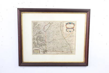
Sold2021Framed Antique Map of Northwest Germany, DeutschlandFramed Antique Map of Northwest Germany. Nicely framed in dark wood with an interior gold border and off-white mat. Tag on the back, which is wood-covered, shows the location of the map within DeutschSee Sold Price
Sold2023MAP: North West Germany Map drawn by Edward Weller FRGS./ Duke Str. BloomsburyDescription: North West Germany Map drawn and Engraved by Edward Weller/ Duke Str. Bloomsbury 1800S. Copy. Material: PaperMeasurement approximate: 21 x 15 (Inches)See Sold Price
Sold2017NORTH AMERICA COLORED MAP, C. 1763, POSTLETHWAYTFramed antique map c. 1770, "North America, Plate 1" from the publication "Dictionary of Trade and Commerce" by Malachy Postlethwayt (British, 1707-1767), hand colored, also reading "North America, PeSee Sold Price
Sold2017NORTH AMERICA COLORED MAP, C. 1763, POSTLETHWAYTFramed antique map c. 1770, "North America, Plate III" and "Part of North America, Plate IV", from the publication "Dictionary of Trade and Commerce" by Malachy Postlethwayt (British, 1707-1767), handSee Sold Price
Sold2018Thomson: Antique Map of Southern Germany, 1817Title/Content of Map: 'Germany, south of the Mayne'. This large, decorative map shows Southern Germany, including the Kingdom of Bavaria, Hesse-Darmstadt, the Grand Duchy of Baden, the Kingdom of WurtSee Sold Price
Sold2020Early Hand Colored Map North America by T ConderAntique framed hand colored early map of North America. Top left image of Native man and foliage, reads "North America agreeable to the most approved Maps and Charts, by Thomas Condor" Frame: 14 3/4 iSee Sold Price
Sold2023Antique Framed Land Map Constable Burton YorkshireAntique Framed Land Map of Constable Burton North RIding of Yorkshire. Framed measures 20 inches x 25 inches.See Sold Price
Sold20241720 antique MAP of GERMANY 18th CENTURY Lower Saxony & North Rhine-WestphaliaCirculi Westphaliae in omnes suos Status et Provincias… 18th century coloured map of Lower Saxony and North Rhine-Westphalia by by Johann Baptist Homann. Shows the area between Hamburg, Cologne, OldSee Sold Price
Sold2017UNITED STATES 1860 MAP, J.W. LOWRY, TERRITORIESFramed map of "The United States of North America (General Map)", c. 1860, "drawn and engraved by" J.W. Lowry (Joseph Wilson Lowry, British, 1803-1879), published by Blackie & Son, Glasgow, EdinburghSee Sold Price
Sold2022MAP OF NORTH POLEBowen, Emanuel. A NEW & ACCURATE MAP OF THE NORTH POLE (ca. 1745). Copper engraving. Hand colored. Framed and mounted. Highly detailed map of North Pole to 50th parallel including surrounding lands anSee Sold Price
Sold2020L'amerique Septentrionale 1706 Map North AmericaL'amerique Septentrionale 1706 Map Of North America (french). 24 X 20 Inches, Framed.See Sold Price
7 days LeftJasper521794 Reilley Map of Surroundings of Marburg Germany -- Des Herzogthums Steyermark Viertel Marburg$70
Jun 15Riverfront AuctionsC. 1730 Map of North Rhine-Westphalia, Germany after N. Sanson by Covens and Mortier$5
5 days LeftThe North Georgia Auction Company LLCClint Alderman Edgefield Area Potteries Map$200(1 bid)
7 days LeftJasper521552 Munster Regional German Map Centered on Bamberg -- Franconia XIII Nova Tabula$95
7 days LeftJasper521691 Coronelli Map of Northwest Germany and Netherlands -- La Vestfalia, detta Altrimenti / Die$120
7 days LeftJasper521552 Munster Map of Central Germany along the Rhein -- Secunda Rheni et IX Nova Tabula$120
7 days LeftJasper521680 de Vit Map of Northwest Germany and Netherlands -- Nova Totius Westphaliae Descriptio$120
3 days LeftEarly American History Auctionsc 1730 Hand-Colored Colonial Era Map of the Americas, California shown as an Island, Matted + Framed$500(1 bid)