Sold2018Framed Map of the World, Dated 1719Framed map of the whole world, dated 1719. [31 x 50 inches]. Moderate condition; tape shows through.See Sold Price
Sold2017FRAMED WORLD MAP BY HERMAN MOLL, 1719'A New & Correct Map of the Whole World, by Herman Moll, Geographer, 1719.' Hand tinted and framed. Frame size: 73 x 124 cm (28 3/4 x 48 3/4 in.)See Sold Price
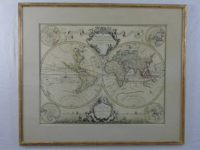
Sold2020Framed 1822 World Map, FrenchDated 1822 world map in frame. This map is hand colored and tilted Mappemomde (French for a map showing two hemispheres). This map is double matted in contemporary frame.Condition: very good conditionSee Sold Price
Sold2017Antique Map "Siciliae Veterisiypus"Framed map, dated 1696. Dimensions: Map- - Sight: 15" H x 20" W; Frame: 23.75" H x 27.75" W; See Sold Price
Sold2020Set 3 Framed Maps. The World, Canada, and MediterraneanSet 3 Framed Maps. The World, Canada, and Mediterranean. -- Dimensions: H: 13.5 inches: W: 18 inches ---See Sold Price
Sold2021Map "MEDELPAD"Framed map "MEDELPAD...", dated 1769. Sight 18 1/2" x 23 1/2", overall 20" x 25".See Sold Price
Sold2022(18) NATIONAL GEOGRAPHIC MAPS, c.1930s-1940s(lot of 18) National Geographic Maps, world maps dated late 1930s to 1940s, with many notes, mileage, and more, housed in book-form album, approx 10.75"h, 7.5"w, 2.25"d, 3.25lbs Start Price: $40.00See Sold Price
Sold20223 PC. FRAMED WORLD MAPS3 PC. FRAMED WORLD MAPS: Comprising; 1- A reduced scale world map based on Mercator's map of 1569. 1- 18th-century hand-colored, A New Map of the Whole World with the Tradewinds According To The LatesSee Sold Price
Sold2016Large Framed World Map w/ Latin InscriptionsLarge Framed World Map w/ Latin Inscriptions. Hand colored. Professionally framed and matted. Titled Mappe Monde. Measures 28 by 33 inches.See Sold Price
Sold2017Hand Colored World Map, FramedHand Colored World Map, Framed. Overall Dimensions: 30 x 33 in. This item is framed behind glass. Late 20th Century.See Sold Price
Sold2023Antique Carte Pour L' Intelligence Du Livre Institute L' Esprit De S Loix Old World Framed MapAntique French framed old world map with gold tone frame. Professionally framed. Measures 15 1/2" x 24" total with 9" x 18" matte.See Sold Price
Sold2023Handcrafted Gemstones Framed World MapHandcrafted Gemstones Framed World Map. 23 1/2 x 31 3/8 in.Local Pick up call one day before to make an appointment. TO SHIP THIS ITEM IN USA OR INTERNATIONAL, PLEASE CONTACT THE SHIPPERS : 1) UPS stoSee Sold Price
Sold202318thC World Map, Framed18th century world map, framed 17" x 24". Provenance: Palm Beach, Florida estate.See Sold Price
Sold2020FRAMED WORLD MAPCondition: with crease mark from book, spotting, and foxing throughout 11 x 16 1/2 inches sightSee Sold Price
Sold2022C. S. Hammond & Co. NY Framed World MapC. S. Hammond & Co. NY Framed World Map. 24 1/2" X 20 1/2"See Sold Price
Sold2021Framed World Map PrintA framed print of a world map as the world was thought to look like in 1632. Map shows both hemispheres laid flat side by side with text and labels in foreign language. Very good condition. Measures 3See Sold Price
Sold2021Framed World MapFramed World map, Blaeu wall map, color print with areas of silvered paper, double matted in mahogany finish 25" x 29" frame. Condition; very goodSee Sold Price
Sold20172 Framed World Maps including Blaeu Wall Map2 Framed World Maps including Blaeu Wall Map. Largest measures 22 x 26 inches.See Sold Price
SoldVintage 1960s Old World Style Metalic Framed World Map ArtworkVery unique styling. See photos for details.29.25" wide25.25" tall1.5" deepSee Sold Price
Sold2017A Group of Three Framed World Maps, 20th CenturyA Group of Three Framed World Maps, 20th Century20 x 28 inches (50.8 x 71.1 cm) (image, laSee Sold Price
Sold2018Kilburg Geochron Wall Mounted World ClockKilburg Geochron Wall Mounted World Clock. The Geochron allows any observer to determine what time it is anywhere in the world. Physically the Geochron looks like a framed world map, about 2×3 ft.See Sold Price
5 days LeftTrillium Antique Prints & Rare BooksKohler & Weigel - Map of the World with North and South Pole views$75(1 bid)
Jun 08Early American History Auctions1836 Hand-Colored Map, Country Twenty Five Miles Round The City Of New-York Published by D.S. Stone$260
Jun 08Early American History Auctions1776 Map, PARTIE ORIENTALE DU CANADA, AVEC LA NOUVELLE ANGLETERRE, L'ACADIE... by P. Santini, Framed$950
Jun 08Early American History Auctions1753 Map of the County of Lancaster Divided into its Hundreds, by Royal Mapmaker Emanuel Bowen$280
Jun 07Freeman's | Hindman[MAP]. ORTELIUS, Abraham. Americae Sive Novi Orbis, Nova Descriptio. 1573.$1,000(1 bid)
Jun 15Crescent City Auction GalleryJohn Tarrell Scott (American/Louisiana, 1940-2007), "Letter to a Third World Friend 2#," 1985, H.- 8$400
Jun 08Early American History AuctionsJockey LAFITTE PINCAY, JR., Racing Program and Booklet Signed Framed Display$500
Jun 07Five Star AuctionsAn Exquisite Monumental 19th C. Italian Ignace Spiridon Framed Oil On Canvas Painting$50,000


![Framed Map of the World, Dated 1719: Framed map of the whole world, dated 1719. [31 x 50 inches]. Moderate condition; tape shows through.](https://p1.liveauctioneers.com/1221/128419/65884062_1_x.jpg?height=310&quality=70&version=1539717036)


![[MAP]. ORTELIUS, Abraham. Americae Sive Novi Orbis, Nova Descriptio. 1573. (1 of 2)](https://p1.liveauctioneers.com/197/329395/177650534_1_x.jpg?height=282&quality=70&version=1715364962)
![[MAP]. SPEED, John. A New Mappe of the Romane Empire. 1676. (1 of 2)](https://p1.liveauctioneers.com/197/329395/177650541_1_x.jpg?height=282&quality=70&version=1715364962)
![[MAP]. ORTELIUS, Abraham. Aevi Veteris, Typus Geographicus. 1601. (1 of 3)](https://p1.liveauctioneers.com/197/329395/177650532_1_x.jpg?height=282&quality=70&version=1715364962)


