Sold2021French Map AssortmentFrench Map Assortment (4) maps from the 'Atlas National Illustre' published by V. Levasseur, Paris in 1851 including 'Dept. Du Finistere', 'Dept. De Seine Et Marne', 'Dept. Du Jura' and 'Dept. Des DeuSee Sold Price
Sold201718th C. French Map w/ Oiled Paper, ex-Sotheby'sEurope, France, map from 1709 CE, oiled paper overlays from 1756 to 1763 CE, owned by Louis-Alexandre Berthier (1753 to 1815 CE), Marshal, Vice-Constable of France, and Chief of Staff (Major general)See Sold Price
Sold2021Antique French Map of MississippiAntique French Map of Mississippi , "Carte Geographique, Statistique et Historique du Mississipi", Paris, Buchon, 1825, sight 21 in. x 27 1/2 in., framed Provenance: Estate of Julia Evans ReedSee Sold Price
Sold2022Map AssortmentMap Assortment (4) items including 'A New Map of Part of the United States of North America, Exhibiting The Western Territory' by John Carey, London 1805; 'Geographical, Statistical and Historical MapSee Sold Price
Sold2021Antique French Map of United States- Etats-Unis De L'Amerique Septentrionale Avec Les Isles Royale, De Terre Neuve, De St. Jean, L'Acadie &c.; Hand-colored; Ches Boudet Imprimeur du Roi; Paris; undated (circa 1785). One of the early maSee Sold Price
Sold2022Mannevillette French Map of the Indian Ocean, 1753D'APRES DE MANNEVILLETTE, Jean-Baptiste-Nicolas-Denis (1707-1780). [Indian Ocean] Carte Reduite de l'Ocean Oriental depuis le Cap de Bonne Esperance... Engraved map with original hand color in part. PSee Sold Price
Sold20241812 large French map of Paris plan routier de la Ville et faubourgLarge engraving of Paris and its surrounding area dated 1812 , cooper engraving in the manner of the Turgot map ,Jean Pierre printer , a Paris, chez Jean, Rue St Jean de Beauvais, N° 10, It is thSee Sold Price
Sold20221738 Antique French Map of North America1738 Antique French Map of North America, 1783 - Antique Map of North America, with documentation, This map is 221 years old - it is not a modern reproduction or copy, This map comes from: ATLAS DE TOSee Sold Price
Sold201718th Century French Map of North AmericaL’Amerique Septentrionale. Daniel de la Feuille (1640-1709). Engraved map with hand color in full. Amsterdam, 1702 or 1706. 6 x 8 inches visible, 13 x 14 1/2 inches framed. Nicely colored early 18thSee Sold Price
Sold2024Framed Map AssortmentFramed Map Assortment (8) items with (3) maps by Willem Blaeu (Dutch, 1571-1638) including c.1660 'Tirolensis', 'Gastinois et Hurepois' and 'Hannoniae et Namurci', (2) maps by Robert de Vaugondy (FrenSee Sold Price
Sold2022c. 1788 French Map of the Eastern United StatesHistoric Maps c. 1788 Map, "Les Etats Unis de L'Amerique Septentrionale, Partie Orientale" (Eastern Part of the Northern United States of America) by M. (Rigobert) Bonne c. 1788 Map titled, "Les EtatsSee Sold Price
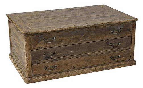
Sold2020Country French Map CabinetThree drawer case in pine with original brass hardware. Drawers pull out from both sides. 49w x 31 1/2d x 20 1/2hSee Sold Price
Sold2023Guillaume De L'Isle Philippe Buache Large Antique French Map of the AmericasImportant map of Guillaume de L'Isle corrected by Philippe Buache and edited by Dezauche in 1800 ,after the conclusion of the American revolutionary war and the treaty of Paris Dezauche updated the neSee Sold Price
Sold20211736 large French map of Paris and surrounding areaLarge engraving of Paris and its surrounding area dated 1736 , cooper engraving in the manner of the Turgot map , name of printer not lisible ,the date is clear . H.23 1/4 x W. 36 , suitable for framiSee Sold Price
Sold202118th C. French Map "Le Noveau Mexique …"Ribobert Bonne (French, 1727-1794). "Le Nouveau Mexique, Avec La Partie Septentrionale De L'Ancien, ou De La Nouvelle Espagne" Published in Paris, 1780. Among the most collected late 18th century mapsSee Sold Price
Sold2021French Map of the World Decorative ArtsFrench Map of the World, piece appears to be hand drawn and colored, inscriptions to piece in French, label to reverse reads ‘Le Normand, Charles 14 x 19 Manuscript World Map’, subject a map of thSee Sold Price
Sold202118TH CENTURY FRENCH MAP OF SOUTHEASTERN USRigobert Bonne (French, 1727-1794). "Carte De la Partie Sud Des Etats Unis De L'Amerique Septentrionale" -circa 1780, engraving. Provenance: From the Lifetime Collection of Billy S. Arant, Jr., ChattaSee Sold Price
Sold2022FRENCH MAP "AFRIQUE" Circa 1720 Color engraving, 8" x 9" sight. Framed 15.5" x 16.5".FRENCH MAP "AFRIQUE"Circa 1720Color engraving, 8" x 9" sight. Framed 15.5" x 16.5".See Sold Price
Sold2018AN 1659 FRENCH MAP OF DENMARK BY NICOLAS SANSONA hand-colored map of Northern Denmark by Nicolas Sanson (1600-1667), signed Sanson and dated with a cartouche on the lower left. Sheet measures 16.25 x 21 inches. Frame measures 20.5 x 26.5 inches. WSee Sold Price
Sold2018Framed 18th C. French Map of Ancient Rome**First Time At Auction** Louis Brion de la Tour (French, 1743-1810) & Louis Charles Desnos (French, 1725-1805), "Suite De L'Histoire De Rome", ca. 1760 to 1770. Copperplate engraved with original hanSee Sold Price
Sold2016French map of U.S. derived from MelishHeading: Author: Buchon, Jean Alexandre Title: Etats-Unis d'Amerique Place Published: Paris Publisher: Date Published: 1825 Description: Copper-engraved map, hand-colored.See Sold Price
Sold2020EARLY FRENCH MAP OF NEW ENGLANDHand-colored. Ca 1750-1760. Map in French. Map 14 1/2 x 12 1/2 inches. Fold marks and water stains. Overall 21 inches x 19 inches. Stains and cut down.See Sold Price
Sold2024Robert Morden (British, 1650-1703) Map AssortmentRobert Morden (British, 1650-1703) Map Assortment (5) items including (4) by Morden pulled from Gibson's edition of 'Camden's Britannia', first Morden edition, published by Abel Swale and John ChurchiSee Sold Price
Jun 09Worthington GalleriesAntique H/C Map EUROPE SOUS CHARLEMAGNE EN 814: EMPIRES D'OCCIDENT ET D'ORIENT$25
Crawford Family Auctions LLC3 pcs Vintage Crystal Decanters w/ Stoppers Assortment. 1x French Cristal d'Arques Bottle. See pi...$21(2 bids)
6 days LeftJasper521881 Vuillemin World Map with French Colonies Shown -- Planisphere: Indiquant les Colonies Francises$30
6 days LeftJasper521760 d'Anville Map of France during Roman Times -- Gallia Antiqua Ex Aevi Romai Monumentis Eruta et$60
Jun 20The Ross Art GroupOriginal Vintage Air France World Route Map Vickers Viscount Poster 1956 Constellation$600
7 days LeftJasper52L'Afrique Françoise ou du Senegal'. French West Africa. DE L’ISLE 1727 map$100
Featured7 days LeftJasper52COLONIES FRANÇAISES en AFRIQUE. Africa Sénégal Madagascar. LEVASSEUR c1850 map$65
6 days LeftJasper521641 MAP of ITALY antique authentic TERRITORIUM BONONIENSE IL BOLOGNESE original$160
Jun 15Crescent City Auction GalleryPair of New Orleans Sanborn Fire Insurance Mock-Up Skeleton Maps of the French Quarter, 1910-1911,$250
3 days LeftGold Coast Auctioneers17th-19th c. French Wall Art Collection Map City Sea Scapes Scenes etc.$50
Featured6 days LeftJasper521640 Blaeu Map of Central France with Clemont-Ferrand as Center -- Auvergne$150
Jun 20The Ross Art GroupOriginal Air France Planisphere Brown Vintage Map by Lucien Boucher 1948$1,200


![Mannevillette French Map of the Indian Ocean, 1753: D'APRES DE MANNEVILLETTE, Jean-Baptiste-Nicolas-Denis (1707-1780). [Indian Ocean] Carte Reduite de l'Ocean Oriental depuis le Cap de Bonne Esperance... Engraved map with original hand color in part. P](https://p1.liveauctioneers.com/1968/250616/130196497_1_x.jpg?height=310&quality=70&version=1654190895)