Sold2022San Francisco Tide Lands for sale at auctionHeading: -1871 Author: Allardt, Geo. F., Surveyor Title: Map No. 6 of Salt Marsh and Tide Lands situated in the City and County of San Francisco, to be sold at public auction by order of the Board ofSee Sold Price
Sold2022Map of San Francisco Tidelands for sale, 1869Heading: -1869 Author: Allardt, Geo. F., Surveyor Title: Map No. 3 of Salt Marsh and Tide Lands Situate in the City & County of San Francisco. To be sold at Public Auction, by order of the Boards of TSee Sold Price
Sold2024A. F. Zurner Map Of EuropeVery colorful, great example of a high quality map of this peroidSee Sold Price
Sold2022San Mateo Co., Cal., Tide Lands at auction 1871Heading: (California - San Mateo County) Author: Allardt, Geo. F., Surveyor Title: Sale Map No. 9. Salt Marsh and Tide Lands situate in the County of San Mateo, State of California. To be sold at publSee Sold Price
Sold2020FloridaTitle: Florida Publication Date: 1884 Cartographer: Cram, Geo. F. Publisher: Cram, Geo. F. Brief Descriptions: Map showing counties, towns, railroads, townships and inset of panhandle of FL. Rev: AlabSee Sold Price
Sold2020New MexicoTitle: New Mexico Publication Date: 1885 Cartographer: CRAM, GEO. F. Publisher: CRAM, GEO. F. Brief Descriptions: Map showing counties, towns, townships, Indian reservations, railroads and topography.See Sold Price
Sold20201939 Nat Geo WWII Eve Map of Europe and theTitle/Content of Map: 1939 Nat Geo WWII Eve Map of Europe and the Mediterranean -- Central Europe and the Mediterranean as of September 1, 1939 Cartographer: National Geographic Society Year/Place: 19See Sold Price
Sold20211821 C F WEILAND GERMAN MAP OF EUROPE1821 C F Weiland German Map of Europe Designed and drawn C. F. Weiland.See Sold Price
Sold2024Becker, F. P. C1845 Antique Map. EuropeSteel Engraved Map Published C1845, London for "A Complete and Universal English Dictionary" by the Rev. James Barclay and B. B. Woodward. Maps by F. P. Becker. Outline hand color. Paper Size: 11 x 8See Sold Price
Sold2019Cuba and the Bahama IslandsTitle/Content of Map: Cuba and the Bahama Islands Date: 1889 Cartographer: CRAM, GEO. F. Publisher: CRAM, GEO. F. Size: 9Height - 12Width Map detailing the tip of FL, the Bahama islands, Cuba, JamaicaSee Sold Price
Sold2017Cram: Antique Map of Nevada[Nevada]. Chicago: Geo. F. Cram, n.d. Coloured map. ca.1800. Approximately 20-3/4 x 13-3/4 inches image area, printed in black on cream paper, with hand colouring. Matted and shrink wrapped. Fine. TheSee Sold Price
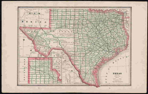
Sold2022Clean 1883 RR map of Texas, Geo. F. CramInteresting cerographic map of Texas from Cram’s Unrivaled Family Atlas of the World. Predates subdivision of Tom Green, Pecos, Crockett and Presidio Counties. Shows rail system throughout statSee Sold Price
Sold2024Marmocchi, F. C. 1845 Hand Col Map. Europe Political Map"Prospetto Geografico Politico della Gallia della Germania della Bretagna della Ibernia" Folio Hand Colored Etching/Engraving Published 1845, Florence for "Atlante di Geografia-Storica Universale" bySee Sold Price
Sold2020IndianaTitle/Content of Map: Indiana Cartographer: CRAM, GEO. F. Date: 1883 Publisher: CRAM, GEO. F. Size: 21.5Height - 15.3Width Scarce. Map detailing counties, towns, townships, rivers, creeks and excellenSee Sold Price
Sold2023AtlantaPublication Date: 1892 Title: Atlanta Cartographer: CRAM, GEO. F. Publisher: CRAM, GEO. F. Height: 12 Width: 9.8 Map with street plan and railroads. Rev: Map of Milwaukee, Wis. with street plan. ReserSee Sold Price
Sold2023City of Portland Maine.Publication Date: 1898 Title: City of Portland Maine. Cartographer: CRAM, GEO. F. Publisher: CRAM, GEO. F. Height: 9.5 Width: 12 Map detailing streets, railroads, bridges, wharves, parks, etc. DetaileSee Sold Price
Sold2019San Diego, Cal.Title: San Diego, Cal. Publication Date: 1899 Cartographer: CRAM, GEO. F. Publisher: CRAM, GEO. F. Size: 13 X 10 Map showing street plan, lg. City Park, railroads, cemeteries, etc. Reserve: $35.00 ShiSee Sold Price
Sold2022QuebecPublication Date: 1887 Title: Quebec Cartographer: CRAM, GEO. F. Publisher: CRAM, GEO. F. Height: 9.8 Width: 12 Map showing the province of Quebec detailing towns, cities, topography and railroads. ReSee Sold Price
Sold2020Brockhaus (Pub) 1890's Mixed Lot of 9 MapsIncl West Indies, America Continent, USA, Alexander The Great, Asia, and Middle East. Lithograph Maps 1892-98 by F. A. Brockhaus, Leipzig for "Brockhaus' Konversations-Lexikon" by Various. Centre foldSee Sold Price
Sold2020Brockhaus (Pub) 1890's Lot of 5 Maps of AfricaAfrica continent, Egypt and Equatorial Africa. Lithograph Maps 1892-98 by F. A. Brockhaus, Leipzig for "Brockhaus' Konversations-Lexikon" by Various. Centre fold as issued. Paper Size: 12 x 10 inch (3See Sold Price
Sold2023Authentic 1888 Railroad map of Colorado from Geo. F. CramPainstaking delineation of topography in this really nice map of Colorado. Shows and names each line of the rail system in place at this time. Locates towns, rivers, springs, forts, military reservatiSee Sold Price
Sold2018Cram's RailRoad & Township Map of Washington.Title: Cram's RailRoad & Township Map of Washington. Publication Date: 1881 Cartographer: GEO. F. CRAM Publisher: GEO. F. CRAM Size: 15.5X19 Published for Geo. F. Cram. Proprietor of the Western Map DSee Sold Price
6 days LeftGold Coast Auctioneers17th-19th c. French Wall Art Collection Map City Sea Scapes Scenes etc.$50
Jun 07Freeman's | Hindman[MAP]. ORTELIUS, Abraham. Presbiteri Iohannis, sive, Abissinorum Imperii Descriptio. 1592.$200
3 days LeftNY Elizabeth M. HANSIZ'S 1729 GERMANIA SACRA BLINDSTAMPED PIGSKIN ANTIQUE FOLIO WITH MAP$50
Jun 12Dan Morphy AuctionsPLATE CXIII. MAP OF INDIAN TERRITORY SHOWING DISTRIBUTION OF WOODLAND” FROM THE TWENTY-FIRST$100
5 days LeftRipley AuctionsCharles Green Shaw, American (1892-1974), untitled, abstract golf scene, oil on canvasboard, 11$2,100(2 bids)
4 days LeftFreeman's | Hindman[CIVIL WAR]. Small archive associated with Lt. Col. William M. Vogelson (1831-1892), 27th Ohio$250


![Cram: Antique Map of Nevada: [Nevada]. Chicago: Geo. F. Cram, n.d. Coloured map. ca.1800. Approximately 20-3/4 x 13-3/4 inches image area, printed in black on cream paper, with hand colouring. Matted and shrink wrapped. Fine. The](https://p1.liveauctioneers.com/5584/107399/55057768_1_x.jpg?height=310&quality=70&version=1501794677)


![[MAP]. ORTELIUS, Abraham. Romani Imperii Imago. 1592. (1 of 2)](https://p1.liveauctioneers.com/197/329395/177650537_1_x.jpg?height=282&quality=70&version=1715364962)

![[MAP]. ORTELIUS, Abraham. Presbiteri Iohannis, sive, Abissinorum Imperii Descriptio. 1592. (1 of 2)](https://p1.liveauctioneers.com/197/329395/177650536_1_x.jpg?height=282&quality=70&version=1715364962)


![[CIVIL WAR]. Small archive associated with Lt. Col. William M. Vogelson (1831-1892), 27th Ohio (1 of 10)](https://p1.liveauctioneers.com/197/329785/177758363_1_x.jpg?height=282&quality=70&version=1715625218)