Sold2022Germany (2), Western Region. 1862 by Johnson and WardTitle: Germany (2), Western Region. 1862 by Johnson and Ward Date/Period: 1862 Materials: Steel plate engraved. Size: 19" x 14" 1862 from 'Johnson's New Illustrated Family Atlas'. By Johnson and Ward.See Sold Price
Sold2019Germany. Part 2,3, western area and south.Title/Content of Map: Germany. Part 2,3, western area and south. Date: 1863 Cartographer: By Johnson & Ward. From, Johnson’s New Illustrated Family Atlas Size: 18x26 1/2” Provenance: New York AddiSee Sold Price
Sold2021Germany (2). North western Germany. Rhineland abdTitle: Germany (2). North western Germany. Rhineland abd Westphalia. By Johnson Date/Period: 1861 Materials: Steel engraved. Size: 18x13” 1861. By A. J. Johnson & J. H Colton. From "Johnson's New IlSee Sold Price
Sold2017Johnson: Map of Palestine, 1862Johnson’ Palestine. Johnson & Ward, 1862. 12.5 x 15.25 inches. Wonderful map of the center of many of the world’s major religions. Shows the region from Beirut south to Busaireh and Kadesh Barnea.See Sold Price
Sold2019Johnson & Ward, "North America," 1862, hand colored,Johnson & Ward, "North America," 1862, hand colored, H.- 26 1/2 in., W.- 18 in.See Sold Price
Sold2019Johnson & Ward, "Germany," 1860-1863, One No. 1, TwoJohnson & Ward, "Germany," 1860-1863, One No. 1, Two No. 2, H.- 26 1/2 in., W.- 18 in.; together with Johnson & Browning, "Germany,"No. 2, 1859, H.- 13 1/4 in., W.- 15 7/8 in. (4 Pcs.)See Sold Price
Sold2019Two Maps by Johnson & Ward, consisting of "Ireland andTwo Maps by Johnson & Ward, consisting of "Ireland and Scotland," 1863-1866, hand colored, H.- 8 in., W.- 26 1/2 in.; together with "England and Wales," 1862, hand colored, H.- 26 1/2 in., W.- 18 in.See Sold Price
Sold2019Map of California & Territories of N.M., AZ, Colorado,Map by Johnson & Ward; bright colors, double truck, 8 counties (2) Lake county; Lake Bigler; (Note, Las Vegas is in Arizona). Approx. 26.5" x 18". There is some foxing & discoloration due to age. No tSee Sold Price
Sold20212 Antique Maps of New England, Johnson & Ward, Mitchell**First Time At Auction** Alvin Jewett Johnson (American, 1827-1884). "Johnson's Massachusetts, Connecticut, and Rhode Island." ca. 1862 AND Samuel Augustus Mitchell (American, 1792-1868). "ConnecticuSee Sold Price
Sold2019Four Maps by Johnson & Ward, consisting of: "North andFour Maps by Johnson & Ward, consisting of: "North and South Carolina," 1862, hand colored, H.- 18 in., W.- 26 3/4 in.; "Arkansas, Mississippi, Louisiana," 1863, hand colored, H.- 26 1/2 in., W.- 18 iSee Sold Price
Sold2019Scarce 1862 Neb/Dak/Col/Kans - Johnson & WardReserve Reduced! One of the rarest and most desirable states of Johnson's Dakota, Nebraska and Kansas map. In this example Nebraska is drawn with a long panhandle extending from Iowa all the way to FrSee Sold Price
Sold2022Dakota’s and Minnesota. 1862, Johnson and WardTitle: Dakota’s and Minnesota. 1862, Johnson and Ward Date/Period: 1862 Materials: Steel plate engraved Size: 19" x 14" 1862 from 'Johnson's New Illustrated Family Atlas' By Johnson and Ward. PuSee Sold Price
Sold2022Title page. 1862. Johnson and WardTitle: Title page. 1862. Johnson and Ward Date/Period: 1862 Materials: Steel plate engraved. Size: 19" x 14" 1862 from 'Johnson's New Illustrated Family Atlas'. By Johnson and Ward. Published in New YSee Sold Price
Sold20241862 Civil War-era map of Alabama/Georgia, Johnson & WardJohnson’s Georgia and Alabama from the 1862 edition of Johnson’s Family Atlas published during the second year of the war in 1862 by Johnson & Ward. Shows railroads operating at the beginnSee Sold Price
Sold2019Johnson’s North America, Johnson & Ward, 1862Interesting configuration of North America, particularly the United States, Canada and Mexico, just after the outbreak of the Civil War. States roughly follow the 1861 configuration with archaic bordeSee Sold Price
Sold2022North America, 1862 by Johnson and WardTitle: North America, 1862 by Johnson and Ward Date/Period: 1862 Materials: Steel plate engraved Size: 19" x 27" 1862 from 'Johnson's New Illustrated Family Atlas' By Johnson and Ward. Published in NeSee Sold Price
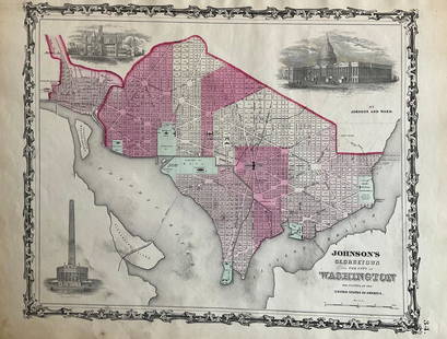
Sold2022Washington D.C. 1862 by Johnson and WardTitle: Washington D.C. 1862 by Johnson and Ward Date/Period: 1862 Materials: Steel plate engraved Size: 19" x 14" 1862 from 'Johnson's New Illustrated Family Atlas' By Johnson and Ward. Published in NSee Sold Price
Sold2022New York. 1862. By Johnson and WardTitle: New York. 1862. By Johnson and Ward Date/Period: 1862 Materials: Steel plate engraved Size: 19" x 27" With inserts of eight cities including New York City, Buffalo, and Albany among others. 186See Sold Price
Sold2022Mexico, 1862 by Johnson and WardTitle: Mexico, 1862 by Johnson and Ward Date/Period: 1862 Materials: Steel plate engraved Size: 19" x 14" 1862 from 'Johnson's New Illustrated Family Atlas' By Johnson and Ward. Published in New York.See Sold Price
Sold2022Maryland and Delaware 1862 by Johnson and WardTitle: Maryland and Delaware 1862 by Johnson and Ward Date/Period: 1862 Materials: Steel plate engraved Size: 19" x 14" 1862 from 'Johnson's New Illustrated Family Atlas' By Johnson and Ward. PublisheSee Sold Price
Sold2022North & South Carolina, insert of Charleston , 1862 by Johnson and WardTitle: North & South Carolina, insert of Charleston , 1862 by Johnson and Ward Date/Period: 1862 Materials: Steel plate engraved Size: 19" x 27" 1862 from 'Johnson's New Illustrated Family Atlas' By JSee Sold Price
Sold2022Cuba, Jamaica with inserts of Puerto Rico and Havana, 1862 by Johnson and WardTitle: Cuba, Jamaica with inserts of Puerto Rico and Havana, 1862 by Johnson and Ward Date/Period: 1862 Materials: Steel plate engraved Size: 19" x 14" 1862 from 'Johnson's New Illustrated Family AtlaSee Sold Price
Sold2022Austrian empire, Hungary, entire Balkans, 1862 by Johnson and WardTitle: Austrian empire, Hungary, entire Balkans, 1862 by Johnson and Ward Date/Period: 1862 Materials: Steel plate engraved. Size: 19" x 27" 1862 from 'Johnson's New Illustrated Family Atlas'. By JohnSee Sold Price
Sold2022Ireland, 1862 by Johnson and WardTitle: Ireland, 1862 by Johnson and Ward Date/Period: 1862 Materials: Steel plate engraved. Size: 19" x 14" 1862 from 'Johnson's New Illustrated Family Atlas'. By Johnson and Ward. Published in New YoSee Sold Price
1 day LeftHolabird Western Americana CollectionsTrinity County Mines (Wall) Map, 1894, Cowden, Johnson [177508]$250
Jun 14Mynt Auctions1941 Warsaw Ghetto Judenrat Poland Germany Postcard Cover 2 Italy Jakub Kunstler$390
2 days LeftSimpson Galleries, LLC.AN AMERICAN CIVIL WAR ERA ATLAS, "Johnson's New Illustrated Family Atlas of the World with Physical$300
1 day LeftMynt Auctions1938 Frankfurt Germany Graf Zeppelin 2 Postcard cover Reichenberg LZ 130 Sports$490
Featured6 days LeftJasper521775-1780. New York, New Jersey, Pennsylvania, Maryland, Virginia and New England states. By Bonne &$120
1 day LeftHolabird Western Americana CollectionsColumbia Transportation Co. Stock, 1863, Very Rare [182133]$120(1 bid)
8 hrs LeftHolabird Western Americana CollectionsHistory of Dakota Territory by Kingsbury, 5 Vols, Rare [180759]$150
1 day LeftHolabird Western Americana CollectionsMining Districts-Sketch Gen. Reilly's Route 1849 [178901]$450
3 days LeftHolabird Western Americana CollectionsWestfalia Notgeld/Cologne Opera House Medals [179289]$50


![Trinity County Mines (Wall) Map, 1894, Cowden, Johnson [177508] (1 of 4)](https://p1.liveauctioneers.com/2699/331495/178785752_1_x.jpg?height=282&quality=70&version=1717094933)


![Micrometer Calipers & Compass [181387] (1 of 6)](https://p1.liveauctioneers.com/2699/331494/178785671_1_x.jpg?height=282&quality=70&version=1717094654)
![Early French Map of Great Lakes [179300] (1 of 1)](https://p1.liveauctioneers.com/2699/331495/178785744_1_x.jpg?height=282&quality=70&version=1717094933)
![Maps of the CA Gold Region, 1942 [182288] (1 of 5)](https://p1.liveauctioneers.com/2699/331495/178785756_1_x.jpg?height=282&quality=70&version=1717094933)
![Columbia Transportation Co. Stock, 1863, Very Rare [182133] (1 of 1)](https://p1.liveauctioneers.com/2699/331495/178786284_1_x.jpg?height=282&quality=70&version=1717094933)
![Nevada City, CA Map, etc. c1930s-50s (3) [180880] (1 of 4)](https://p1.liveauctioneers.com/2699/331495/178785751_1_x.jpg?height=282&quality=70&version=1717094933)
![Maps of CA Gold Region, Grabhorn, 1942 [181936] (1 of 6)](https://p1.liveauctioneers.com/2699/331495/178785755_1_x.jpg?height=282&quality=70&version=1717094933)
![History of Dakota Territory by Kingsbury, 5 Vols, Rare [180759] (1 of 5)](https://p1.liveauctioneers.com/2699/331494/178785527_1_x.jpg?height=282&quality=70&version=1717094654)
![Sioux Chief Sha-Kpe Carte de Viste [182810] (1 of 1)](https://p1.liveauctioneers.com/2699/331494/178785236_1_x.jpg?height=282&quality=70&version=1717094654)
![French Map of America Southeast [179304] (1 of 1)](https://p1.liveauctioneers.com/2699/331495/178785746_1_x.jpg?height=282&quality=70&version=1717094933)
![Mining Districts-Sketch Gen. Reilly's Route 1849 [178901] (1 of 3)](https://p1.liveauctioneers.com/2699/331495/178785791_1_x.jpg?height=282&quality=70&version=1717094933)
![Chicago & Alton RR pass, 1896 [179560] (1 of 2)](https://p1.liveauctioneers.com/2699/331495/178785868_1_x.jpg?height=282&quality=70&version=1717094933)
![Westfalia Notgeld/Cologne Opera House Medals [179289] (1 of 2)](https://p1.liveauctioneers.com/2699/331499/178846358_1_x.jpg?height=282&quality=70&version=1717095214)