Sold2021Impressive map of Louisiana, O. W. Gray, 1875Title: Impressive map of Louisiana, O. W. Gray, 1875 Description: Great vintage hand colored map of this beautiful Gulf state. Wonderful detailing of the southern marshy areas along the coast, and nicSee Sold Price
Sold2023Vintage Hand Colored Map of St. PetersburgVintage hand colored map of St. Petersburg. [Map: 13" H x 15" W; Frame: 18" H x 21" W]. Foxing.See Sold Price
Sold2018AMERICAN - INDIA NOVA Vintage Hand Colored Map FramedAMERICAN - INDIA NOVA Vintage Hand Colored Map Framed.Size: 21.5 x 27.5 edge of frameSee Sold Price
Sold20241835 Visible Heavens in April, May and June, E. H. BurrittGreat hand-colored map of the visible constellations in the second quarter of the year by Elijah H. Burritt. These are from Burritt’s 1835 edition of his atlas which, due to the rarity of the 18See Sold Price
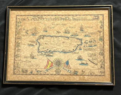
Sold2023Vintage Hand -Colored Pictorial Map of Puerto Rico Circa 1931 by E.B.K. DooleyA vintage hand-colored map of Puerto Rico by E.B.K. Dooley, published c. 1931. This map has a decorative border filled with local plants, wildlife, buildings and transportation. In small scrolls, therSee Sold Price
Sold20231835 Visible Heavens in April, May and June, E. H. BurrittGreat hand-colored map of the visible constellations in the second quarter of the year by Elijah H. Burritt. These are from Burritt’s 1835 edition of his atlas which, due to the rarity of the 1See Sold Price
Sold20231860 map of New Orleans by S. A. Mitchell, Jr.Vintage hand-colored map from Mitchell’s New General Atlas depicts the city of New Orleans. The heart of the city is shown in this colorful plan, with Bourbon and Canal Streets clearly marked. TSee Sold Price
Sold20221814 map of Romanum Imperium by Robt. WilkinsonVintage hand colored map from the unique Atlas of Ten Select Maps of Ancient Geography by John P. Watson. This is the only known edition of this atlas. The map is by Robert Wilkinson. A legend on theSee Sold Price
Sold2021Scarce 2-pg map of S. Calif/Arizona, 1882Great hand-colored and scarce map of lower California and Arizona. This map comes from the extremely scarce 1882 Cram’s Unrivaled Family Atlas of the World, one of the few Cram atlases to includSee Sold Price
Sold2023Vintage John H. Martin Hand Colored Map of Nantucket "Soil Associations"Vintage John H. Martin Hand Colored Map of Nantucket "Soil Associations", color key showing the different soil types and locations of each on the island, by John H. Martin Harvard University. OverallSee Sold Price
Sold2021Scarce Colton 2-page map of Texas, c1884Breathtakingly large, fully hand-colored vintage map of Texas from the very scarce 1890 edition of Colton’s General Atlas. This is the only edition of this atlas that I’ve ever seen—See Sold Price
Sold2023Scarce RR map of Georgia, Cowperthwait 1850Steel engraved, hand-colored vintage map of Georgia. Excellent detail in depicting the roads and railroads that crisscross the state. Railroad lines highlighted in red; canals highlighted in blue. PolSee Sold Price
Sold2017PAIR OF VINTAGE BATTLE MAP HAND COLORED ENVRAVINGSPAIR OF VINTAGE BATTLE MAP HAND COLORED ENGRAVINGS. Height: 28 & 22 in. by Width: 40 1/2 & 34 1/2 in.See Sold Price
Sold2015EARLY HAND COLORED MAP OF GREAT BRITIAN, PRINTED INEARLY HAND COLORED MAP OF GREAT BRITIAN, PRINTED IN TOP RIGHT- AN ACCURATE MAP OF GREAT BRITIAN FROM THE LATEST AND BEST OBSERVATIONS. MAP MEASURES 17 1/2" X 14 1/2". LAYING ON GREEN MATERIAL IN GOLDSee Sold Price
Sold2023Authentic pre-Civil War railroad map of TennesseeBeautifully hand colored vintage railroad map of Tennessee by Thomas, Cowperthwait. Also includes insets of Environs of Nashville and Environs of Knoxville. Shows operational railroads in red orange.See Sold Price
Sold2018Map of the Basin of the St. Lawrence.[Map] Keefer, Thomas C. Map of the Basin of the St. Lawrence. New York: Ackerman Litho., 1853. Hand-colored map depicting the Great Lakes Region for Isreal de Wolf Andrew’s report for the TreasuSee Sold Price
Sold2019OGILBY, John (1600-1676). The Road from CambridgOGILBY, John (1600-1676). The Road from Cambridg to Coventry. [London, ca 1570s]. Engraved scroll map hand-colored in wash and outline, visible area 17 1/4 x 14 1/14 in. (444 x 360 mm). DecoSee Sold Price
Sold2016Map of Ancient Germany by JanssonHeading: Author: Jansson, Jan Title: Germaniae Veteris, Typus Place Published: Amsterdam Publisher: Date Published: c.1640 Description: Copper-engraved map, hand-colored inSee Sold Price
Sold2017Mitchell: County Map of Texas, 1862County Map of Texas, S. Augustus Mitchell, 1862. 10.75 x 13.375 inches. Steel engraved map, with hand colored wash and outlines. Inset map of Galveston Bay, and Vicinity. Colored by county and territoSee Sold Price
Sold2023AFTER NICOLAS SANSON (FRENCH, 1600-1667) MAP OF GREAT BRITAINAFTER NICOLAS SANSON (FRENCH, 1600-1667) MAP OF GREAT BRITAIN, hand-colored engraving on laid paper, engraving by Robert De Vaugondy. Unframed. Circa 1750. 21 3/4" x 31". Provenance: BSee Sold Price
Sold2018Late 16th c. hand colored map of IrelandGerhard Mercator (German-Flemish, 1512-1594), late 16th century hand-colored map of Ireland in two parts, titled 'Irlandiae Regnum Miliaria Irlandica Communia,' 17"h x 21"w sight of each sheet, overalSee Sold Price
Sold2016(3) 19th c. hand colored maps of ConnecticutGrouping of three circa 1867 hand colored maps and one black and white advertisement from the "Atlas of New York and Vicinity" by Beers, Ellis & Soule, the drawings based on land surveys performed undSee Sold Price
Sold2015(3) 19th c. hand colored maps of ConnecticutGrouping of three circa 1867 hand colored maps from the "Atlas of New York and Vicinity" by Beers, Ellis & Soule, the drawings based on land surveys performed under the direction of F.W. Beers, includSee Sold Price
Sold2024Thomson's 1817 Hand Colored Map Comparative Heights of the World's Great MountainsAntique hand-colored Thomson's 1817 Map of the Comparative Heights of the World's Great Mountains framed. Good sight condition, apparent repair upper middle right. Framed, matted, and sealed under pleSee Sold Price
Jun 08Early American History Auctions1753 Map of the County of Lancaster Divided into its Hundreds, by Royal Mapmaker Emanuel Bowen$280
Jun 07Freeman's | Hindman[MAP]. TODESCHI, Pietro. [Nova et Acurata Totius Americae Tabula auct. G.I. Blaeu] America quarta$5,000
Jun 04Mark Louis Weseloh Estate Liquidations17th cent. John Speed Map of the Isle of Man. Hand Colored, 22" x 17 1/2",$300
Featured14 hrs LeftJasper52c1720 World showing Dutch East India Co possessions. CA as a island. By J.Malherbe$600
4 days LeftTrillium Antique Prints & Rare BooksWilson - Green Heron, Night Heron, & Great White Heron. 61$75
4 days LeftTrillium Antique Prints & Rare BooksDonovan's The Natural History of British Shells - 5 Volumes in 2 Books with 180 Engravings$400
Jun 07Jasper52Vintage Small Child’s Wood and Glass Wash Board, Crystal Washboard Co., Circa 1930s$75
Jun 08Early American History Auctions1836 Hand-Colored Map, Country Twenty Five Miles Round The City Of New-York Published by D.S. Stone$260
Jun 09Worthington GalleriesFirst Edition Hand-colored Map THE NORTH RIDING OF YORKSHIRE by Robert Morden$50


![Vintage Hand Colored Map of St. Petersburg: Vintage hand colored map of St. Petersburg. [Map: 13" H x 15" W; Frame: 18" H x 21" W]. Foxing.](https://p1.liveauctioneers.com/1221/275442/145469144_1_x.jpg?height=310&quality=70&version=1675222498)


![Map of the Basin of the St. Lawrence.: [Map] Keefer, Thomas C. Map of the Basin of the St. Lawrence. New York: Ackerman Litho., 1853. Hand-colored map depicting the Great Lakes Region for Isreal de Wolf Andrew’s report for the Treasu](https://p1.liveauctioneers.com/928/124137/63148817_1_x.jpg?height=310&quality=70&version=1530051387)
![OGILBY, John (1600-1676). The Road from Cambridg: OGILBY, John (1600-1676). The Road from Cambridg to Coventry. [London, ca 1570s]. Engraved scroll map hand-colored in wash and outline, visible area 17 1/4 x 14 1/14 in. (444 x 360 mm). Deco](https://p1.liveauctioneers.com/197/151909/76680351_1_x.jpg?height=310&quality=70&version=1570472488)


![[MAP]. TODESCHI, Pietro. [Nova et Acurata Totius Americae Tabula auct. G.I. Blaeu] America quarta (1 of 1)](https://p1.liveauctioneers.com/197/329395/177650542_1_x.jpg?height=282&quality=70&version=1715364962)


