Sold2023Vintage Hand Colored Map of St. PetersburgVintage hand colored map of St. Petersburg. [Map: 13" H x 15" W; Frame: 18" H x 21" W]. Foxing.See Sold Price
Sold2018AMERICAN - INDIA NOVA Vintage Hand Colored Map FramedAMERICAN - INDIA NOVA Vintage Hand Colored Map Framed.Size: 21.5 x 27.5 edge of frameSee Sold Price
Sold2021Impressive map of Louisiana, O. W. Gray, 1875Title: Impressive map of Louisiana, O. W. Gray, 1875 Description: Great vintage hand colored map of this beautiful Gulf state. Wonderful detailing of the southern marshy areas along the coast, and nicSee Sold Price
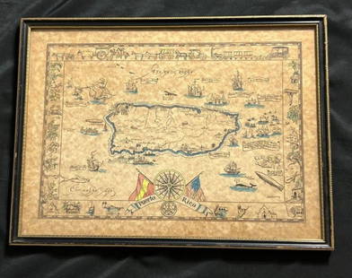
Sold2023Vintage Hand -Colored Pictorial Map of Puerto Rico Circa 1931 by E.B.K. DooleyA vintage hand-colored map of Puerto Rico by E.B.K. Dooley, published c. 1931. This map has a decorative border filled with local plants, wildlife, buildings and transportation. In small scrolls, therSee Sold Price
Sold20231860 map of New Orleans by S. A. Mitchell, Jr.Vintage hand-colored map from Mitchell’s New General Atlas depicts the city of New Orleans. The heart of the city is shown in this colorful plan, with Bourbon and Canal Streets clearly marked. TSee Sold Price
Sold20221814 map of Romanum Imperium by Robt. WilkinsonVintage hand colored map from the unique Atlas of Ten Select Maps of Ancient Geography by John P. Watson. This is the only known edition of this atlas. The map is by Robert Wilkinson. A legend on theSee Sold Price
Sold2020Hand Colored Map of St. Georges ChannelFramed and matted hand colored map of St. Georges Channel and the Irish Sea, R.W. Seale 19" x 15" sight size / 25" x 21" overall Condition: some creasing, not examined out of the frameSee Sold Price
Sold2023Vintage hand painted st Petersburg mother of pearl broochMeasurements: 2" long by 1 1/2" wide Material: mother of pearl condition: good SKU-1338See Sold Price
Sold2021TWO FRAMED PRINTS.Nineteenth century. One is "Napoleon Wounded in Front of Regensburg." 11"h. 12.5"w. And a hand-colored map of St. Helena and the Bay Agoa de Saldanha. 12.5"h. 9.75"w.See Sold Price
Sold2021After: Charlemagne "Views St. Petersburg" LithoAfter: Charlemagne European School Hand Colored Lithograph "Views St. Petersburg" Printed by Jacottet and Auburn Paris for Daziaro. Good condition. Measures 12-1/4" x 16-1/4", frame measures 21-1/4" xSee Sold Price
Sold2023Vintage John H. Martin Hand Colored Map of Nantucket "Soil Associations"Vintage John H. Martin Hand Colored Map of Nantucket "Soil Associations", color key showing the different soil types and locations of each on the island, by John H. Martin Harvard University. OverallSee Sold Price
Sold2021Scarce Colton 2-page map of Texas, c1884Breathtakingly large, fully hand-colored vintage map of Texas from the very scarce 1890 edition of Colton’s General Atlas. This is the only edition of this atlas that I’ve ever seen—See Sold Price
Sold2023Scarce RR map of Georgia, Cowperthwait 1850Steel engraved, hand-colored vintage map of Georgia. Excellent detail in depicting the roads and railroads that crisscross the state. Railroad lines highlighted in red; canals highlighted in blue. PolSee Sold Price
Sold2017PAIR OF VINTAGE BATTLE MAP HAND COLORED ENVRAVINGSPAIR OF VINTAGE BATTLE MAP HAND COLORED ENGRAVINGS. Height: 28 & 22 in. by Width: 40 1/2 & 34 1/2 in.See Sold Price
Sold2022Compton & Dry, 1875, Topographical Survey, St. Louis, Downtown, Plate #74Compton & Dry, 1875, Topographical Survey, St. Louis, Downtown, Plate #74Hand-colored lithograph, topographical map of downtown St. Louis in 1875 showing 18th to Jefferson streets and Saint Louis Ave.See Sold Price
Sold2023Authentic pre-Civil War railroad map of TennesseeBeautifully hand colored vintage railroad map of Tennessee by Thomas, Cowperthwait. Also includes insets of Environs of Nashville and Environs of Knoxville. Shows operational railroads in red orange.See Sold Price
Sold2023Antique French Map Isle de Saint ChristopheAntique MDCCLVIII French Language Hand Colored Map of Isle de Saint Christophe (St. Kitts), Framed. 31 inches x 42 inchesSee Sold Price
Sold2018B. Patersson St Petersburg Watercolor / EtchingBenjamin Patersson (Swedish, 1748-1815) "Saint Petersbourg, Russia," watercolor / hand-colored etching, circa 1799, label on reverse, "Christies NYC / CK 301 / KLH / Elsie Lot 422 10/30/85." Image: 15See Sold Price
Sold2023A FRENCH COLORED LITHOGRAPH A VIEW OF ST. PETERSBURG, 18 C.Michel Francois Damame-Demartrais, original hand-colored aquatint and etching "View of the Peter and Paul fortress in St. Petersburg in winter," 1796-1801. Matted and framed. Note: Michel Francois DamSee Sold Price
Sold2018Map of the Basin of the St. Lawrence.[Map] Keefer, Thomas C. Map of the Basin of the St. Lawrence. New York: Ackerman Litho., 1853. Hand-colored map depicting the Great Lakes Region for Isreal de Wolf Andrew’s report for the TreasuSee Sold Price
Sold2023Vintage Framed Map, City of Kingston NYhand colored map by Thomas Hunter; Burleigh Litho. Frame size: 28 1/4" high, 36 3/4" wide. Light toning, small stain.See Sold Price
Sold2024MAP, St. Petersburg, Daumont Co.St. Petersburg, Russia. Daumont Company, Area Magna Petropolitana / La Grande Place de Petersbourg, 1780 (circa). Hand Color. This striking view depicts a vast street or courtyard in St. Petersburg. VSee Sold Price
Sold2021Large hand colored map of Asia, 1875Large vintage map of Asia in the not-often seen hand-colored version. Most likely drawn by A. K. Johnston, and appearing the very scarce Jones and Hamilton Atlas of the World Illustrated, published 18See Sold Price
Sold2022Hand-colored maps of CanadaHeading: (Canada) Author: Title: Atlas of the Maritime Provinces of the Dominion of Canada, with historical and geological descriptions... Place Published: St. John, N.B. Publisher:Roe BrothersSee Sold Price
5 days LeftArarity AuctionsThomson's 1817 Hand Colored Map Comparative Heights of the World's Great Mountains$50
1 day LeftThomaston Place Auction GalleriesHAND COLORED MAP OF PERU & COUNTRY OF THE AMAZONS, 1747, BY EMANUEL BOWEN, FRAMED$250
Jun 08Early American History Auctions1836 Hand-Colored Map, Country Twenty Five Miles Round The City Of New-York Published by D.S. Stone$260
Jun 08Early American History Auctions1776 Map, PARTIE ORIENTALE DU CANADA, AVEC LA NOUVELLE ANGLETERRE, L'ACADIE... by P. Santini, Framed$950


![Vintage Hand Colored Map of St. Petersburg: Vintage hand colored map of St. Petersburg. [Map: 13" H x 15" W; Frame: 18" H x 21" W]. Foxing.](https://p1.liveauctioneers.com/1221/275442/145469144_1_x.jpg?height=310&quality=70&version=1675222498)


![Map of the Basin of the St. Lawrence.: [Map] Keefer, Thomas C. Map of the Basin of the St. Lawrence. New York: Ackerman Litho., 1853. Hand-colored map depicting the Great Lakes Region for Isreal de Wolf Andrew’s report for the Treasu](https://p1.liveauctioneers.com/928/124137/63148817_1_x.jpg?height=310&quality=70&version=1530051387)


