Sold2023Group of Five MapsGroup of Five Maps, to include a new map of ancient Greece Thrace by William; Sweden; East Nottingham; Ireland; along with South Eastern Greece Attica Megorica Corinthiaca engraved map; largest 15" xSee Sold Price
Sold2020Grp: 5 Maps of Africa Jaillot DelisleGroup of five maps of Africa. Includes Hubert Jaillot (1632-1712), "L'Afrique divisee suivant l'estendue de ses principales parties, ou sont distingues les uns des autres les Empires, Monarchies, RoyaSee Sold Price
Sold2023DENNIS HOPPER | NEW MEXICO TOPOGRAPHICAL MAPSA group of five topographical maps of New Mexico from the personal collection of Dennis Hopper. PROVENANCE Property from the Life and Career of Dennis Hopper;See Sold Price
Sold2020Grp: 5 Maps of Germany Europe and the MediterraneGroup of five 18th century maps. This group includes a hand colored map of Germany by Herman Moll (ca. 1654-1732); one map of the Turkish empire by Tobias Conrad Lotter (1717-1777); one map of the BriSee Sold Price
Sold2018Group of Five U.S. Army Battle Maps of Okinawa, Japan.[WWII] Group of Five U.S. Army Battle Maps of Okinawa, Japan. Army Map Service, 1945. Printed reference maps prepared “For use by War and Navy Department Agencies Only”. Includes air traffSee Sold Price
Sold2019Group of Five (5) 19th Century MapsIncluding England Scotland and Ireland Britain or the United Kingdom published by Cummings & Hillard No. 1 Cornhill Boston, Newfoundland Nova Scotia and New Brunswick map, French map of North America,See Sold Price
Sold2024Group of Five Signal Oil Road MapsVarious years and covers, fair to good conditionSee Sold Price
Sold2023GROUP OF 5 HAND COLORED MAPS OF THE AMERICASGroups of five hand colored antique maps of the Americas, comprising "America Merioio-Nalis (South American)" circa 1620, "Tabula Magellanica Qua Tierre Del Fuego (Strait of Magellan)" circa 1640, "IlSee Sold Price
Sold2021A group of five American state and city maps,A group of five American state and city maps, comprising: Wisconsin. Philadelphia: Thomas, Cowperthwait & Co., N.d. 19 1/2 x 17 1/8 In. -- Ohio. New York: J.H. Colton, 1855. 17 1/2 x 20 1/2 In. Some gSee Sold Price
Sold2020Grp: 5 Maps of Sicily Italy 18th/19th c. JaillotGroup of five 18th and 19th century maps of Sicily. Includes Hubert Jaillot , "La Sicile divisee en ses trois Provinces ou Valees, scavoir Valle Demona, Valle Di Noto, et Valle Di Mazara;" and GuillauSee Sold Price
Sold2017Group of Antique Hawaiian Territory Survey MapsGroup of Antique Hawaiian Territory Survey Maps, five total including: Maui County, Kahoolawe, Niihau and Molokai, color surveys by the Andrew B. Graham Co. of Washington D.C., dated 1897, largest 27"See Sold Price
Sold2020[Maps & Atlases] [London] Stow, John, Group of 5 maps[Maps & Atlases] [London] Stow, John Group of 5 maps of London London, 1754-55. Approximately 18 1/2 x 15 7/8 inches. Five matted maps from Stow's "A Survey of Cities of London and Westminster and theSee Sold Price
Sold2019Group of Five Early 20th Century History Books.Group of Five Early 20th Century History Books. Includes: Harmon’s Journals by Daniel Williams Harmon (1903, folding map); Taxation in American States and Cities by Richard T. Ely (1888, first eSee Sold Price
Sold2021(5) Circa 1930s Pull Down School MapsGroup Lot of Five (5) Circa 1930s Pull Down School Maps. (4) are drawn by R. Baxter Blair. Editors: S. Van Valkenburg, D. Sc.,Charles C. Colby Ph. D., Clarence F. Jones, Ellworth Huntington Ph. D. andSee Sold Price
Sold20165 Copies of Early Maps by Penn Prints, New York.Five Copies of Early Maps by Penn Prints, New York. All are framed and measure 15-3/4" x 20-1/2" overall. Condition: Good with light foxing.See Sold Price
Sold2021Miscellaneous Group of Books on Ivories, Glass,Miscellaneous Group of Books on Ivories, Glass, Enamels, Maps, and Frames Approximately twenty-five books. Including: Josef Vydra, Folk Painting on Glass Giovanni Mariacher, Italian Blown Glass: FroSee Sold Price
Sold2023Sixteen Northern Railroad Timetables and Map - 1911 to 1967 Northern Pacific and Great NorthernA group of sixteen northern railroad timetables and a map spanning 1911 to 1967. Five Northern Pacific tables dated 1915, 1959, 1962, and 1967. A Great Northern Railway foldout route map and ten tableSee Sold Price
Sold2018Five Vintage World's Fair Souvenir Canes.Lot of Five Vintage World's Fair Souvenir Canes. Two 1933 Chicago and three 1939 New York. Including a New York 1939 World's Fair pull-out map cane. Largest measures 38-1/4"l. Condition: Good with weaSee Sold Price
Sold2022Five Maps of NantucketFour of the island and one of Main Street, including one by Tony Sarg (German, 1880-1942) Frames loose. Sizes from 17"h x 20"w to 23"h x 34"w overallSee Sold Price
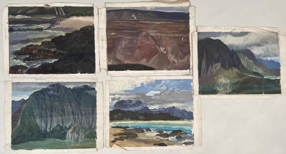
Sold2023Savage, Group Five Hawaiian Oil SketchesEugene Francis Savage (Am. 1883-1978) Hawaiian and tropical scenes. Largest: 17" high, 23" wide. All with estate stamp. Estate found condition, losses. Please refer to photos.See Sold Price
Sold2023Savage, Group Five Hawaiian Oil Sketcheslabelled as to location, Eugene Francis Savage (Am. 1883-1978). Largest: 17" high, 22" wide. All with estate stamp. Estate found condition, losses. Please refer to photos.See Sold Price
Sold2023Savage, Group Five Mural Studies, C/PEugene Francis Savage (Am. 1883-1978), several signed and dated. Largest: 17" high, 13" wide. Pinholes, toning and soiling.See Sold Price
Sold2022Group Five Paperweights: Clichy, Millefioriincluding two attributed to Clichy, Largest 2 1/2" high, 4 1/4" diameter. Scuffing, some contact marks, two with age and use wear. Property of a NC gentleman.See Sold Price
4 days LeftNadeau's Auction GalleryGroup of Five Herend "Queen Victoria" Pattern Porcelain Serving Pieces$450(3 bids)
4 days LeftTHOS. CORNELL GALLERIES, LTD.GROUP OF FIVE NICELY MATTED AND FRAMED ENGRAVINGS, FOUR LANDSCAPES AND "FOX HUNTING" (SOME MILDEW),$50


![Group of Five U.S. Army Battle Maps of Okinawa, Japan.: [WWII] Group of Five U.S. Army Battle Maps of Okinawa, Japan. Army Map Service, 1945. Printed reference maps prepared “For use by War and Navy Department Agencies Only”. Includes air traff](https://p1.liveauctioneers.com/928/124137/63148928_1_x.jpg?height=310&quality=70&version=1530051387)


![[Maps & Atlases] [London] Stow, John, Group of 5 maps: [Maps & Atlases] [London] Stow, John Group of 5 maps of London London, 1754-55. Approximately 18 1/2 x 15 7/8 inches. Five matted maps from Stow's "A Survey of Cities of London and Westminster and the](https://p1.liveauctioneers.com/65/168030/84729856_1_x.jpg?height=310&quality=70&version=1588715715)