Sold2017Burgess: Antique Map of the United States & Canada 1853Map of the United States and Canada, Burgess 1853. Great map of the U. S. during the transitional period of the American West. Most of the western lands are shown as large territories: Minnesota, NebrSee Sold Price
Sold2022Scarce 1856 Map of Great West, still in bookScarce and fascinating early map of the Plains, Midwest and Rocky Mountains, drawn by E.F. Beadle and published by Miller, Orton & Mulligan in “The States and Territories of the Great West.&rdquSee Sold Price
Sold2022Scarce Hardesty map of Southwest US, 1875Great map of the West, noting copper, silver and gold regions throughout southern Arizona and New Mexico. “Map of Colorado, Utah, New Mexico and Arizona,” by J. David Williams. Published 1875 by HSee Sold Price
Sold2018Transitional western states with Gadsden Terr. – 1860sReserve Reduced! Great map of the West, naming Gadsden Territory as a separate region before it’s named Arizona. Map was issued shortly after the formation of Arizona, Nevada and Wyoming, each of whSee Sold Price
Sold2022La Salle - Discovery of the West - Francis ParkmanLa Salle and the Discovery of the Great West Fold-out Map Present. Author: Francis Parkman Dated: 1899 Publisher: Little Brown Size: 8vo<See Sold Price
Sold2023Fur Country of the Far West Map by Hafen [161295]Red and black Fur Country of the Far West map by Leroy Hafen. A great map of the early West with historical detail. Hafen was born in Nevada in 1893 and died in 1985 in Palm Desert. He was a historianSee Sold Price
Sold2021Johnson map of American West – great color, 1864Authentic vintage maps of the American West—especially during the years of constant boundary change--are extremely collectible. Exceptional examples with great color and crisp ink impressions arSee Sold Price
Sold20191853 No. 4 United States, BurgessInteresting map of the Atlantic states from Mitchell’s 1853 School Atlas published by Thomas, Cowperthwait & Co. The map is copyrighted by Daniel Burgess. In this map West Virginia is still part ofSee Sold Price
Sold2020Hunting Grounds of the Great West 1877The Hunting Grounds of the Great West. 1877. Chatto and Windus, London. Frontispiece portrait, fold-out map and 19 plates. 440 pp. Ex-library with date stamps on several pages and 'F' inside front covSee Sold Price
Sold2023HOLY ROMAN EMPIRE. Europe. Otto the Great 962. Spread of Christianity 1902 mapTITLE/CONTENT OF MAP: 'Europe at the time of the Restoration of The Empire in the West by Otto the Great 962; Inset map of Spread of Christianity about the year 1000' DATE PRINTED: 1902 IMAGE SIZE: ApSee Sold Price
Sold2024HOLY ROMAN EMPIRE. Europe. Otto the Great 962. Spread of Christianity 1902 mapTITLE/CONTENT OF MAP: 'Europe at the time of the Restoration of The Empire in the West by Otto the Great 962; Inset map of Spread of Christianity about the year 1000' DATE PRINTED: 1902 IMAGE SIZE: ApSee Sold Price
Sold2017Map of West Virginia coal field 1867Heading: Author: Swann, John S. Title: Title Map of the Coal Field of the Great Kanawha Valley, West Virginia, United States of America Place Published: New York Publisher:G.W. Colton & C.B. Colton &See Sold Price
Sold2018Map of the Basin of the St. Lawrence.[Map] Keefer, Thomas C. Map of the Basin of the St. Lawrence. New York: Ackerman Litho., 1853. Hand-colored map depicting the Great Lakes Region for Isreal de Wolf Andrew’s report for the TreasuSee Sold Price
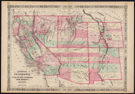
Sold2022Scarce Johnson map of the Great Western states, 1864Antique map of California, Nevada, Utah, Colorado, New Mexico, and Arizona. Published during a great time of expansion and change in the U.S. West, as well as during the Civil War. Here Utah displaysSee Sold Price
Sold20231873 Map of the Great PlainsStrinking map of the Western United States, primarily illustrating the various regions and mountain systems West of the Mississippi River. ca. 1873See Sold Price
Sold2023Seutter - Map of North America including Great Lakes, Florida, Virginia, New England, Mexico, WestThis engraving is from a composite atlas presented by the Homann Heirs. Many of the maps in the collection were completed by J. B. Homann, Homann Erben, M. Seutter, and T. C. Lotter. The maps were oriSee Sold Price
Sold2021[WALL MAP]. Colton's map of the U.S.A . NY: 1853J.H. COLTON (publisher) [WALL MAP]. Colton's map of the United States of America, the British provinces, Mexico and the West Indies. [WALL MAP]. Colton's map of the United States of America, the BritiSee Sold Price
Sold2022Antique Map Ireland Correct Chart St George's ChannelA Correct Chart of St. George's Channel and the Irish Sea, including all of the coast of Ireland and the West Coast of Great Britain from Cantire to Portland Isle. It indicates it is From the latest aSee Sold Price
Sold2021Scarce 1847 map of Western Terr. Of the U. S.Title: Scarce 1847 map of Western Terr. Of the U. S. Description: Great and uncommon map showing the transitional boundaries of the American West c1840s. massive Oregon Territory, encompassing futureSee Sold Price
Sold2023VERY RARE WALL MAP OF THE CITY OF BANGOR,PENOBSCOT COUNTY, MAINE. 1853, Bangor, Maine. "Published Under the Patronage of the City Government Henry F. Walling, Civil Engineer, 81 Washington St. Boston 1853". "S.S. Smith, Publisher 17 West MarSee Sold Price
Sold2018Scarce 1853 Calif. & western states, CowperthwaitReserve Reduced! One of the important obtainable maps of California and the American west. Important depiction of the west at a time of dramatic change, both in terms of geographic discovery and politSee Sold Price
Sold20191863 Johnson’s Neb., Dak., Col., Ida., Kans.Johnson and Ward's rare 1863 map of the territories of Idaho, Dakota, Nebraska, Colorado and Kansas. Extends west as far as the Great Salt Lake and east to Lake Superior. Depicts this area during inteSee Sold Price
Sold20171855 map of Virginia by G. W. ColtonItem: 1855 map of Virginia by G. W. Colton Description: Great hand color and clean. Virginia before West Virginia became a separate state. Insets of Richmond and Norfolk. From the 1856 edition of ColtSee Sold Price
Sold2022Western Travel notices 1800's: GN, C&GN, CB&Q4 advertising pieces of paper from the American West. All are 1800s and none are dated. Great Northern cardstock card with map and immigration info, MoPac - folding "Settlers" Excursion schedules andSee Sold Price
6 days LeftJasper52The River of Thames from London to the Buoy of ye Noure. MOUNT & PAGE 1758 map$700
BonhamsLINFORTH (JAMES, EDITOR) Route from Liverpool, to Great Salt Lake Valley Illustrated...by Freder...£1,400
6 days LeftJasper52LSE POVERTY OS PROOF MAP West Ham Park - Plashet - Forest Gate - Woodgrange 1928$800
1 day LeftEarly American History Auctions1853 Specialized Map, Railroads in the United States in Operation and Progress... Treasury Deptment$200(1 bid)
1 day LeftEarly American History Auctions1853 Map, Basin of the St. Lawrence, by T. Keefer showing Natural + Artificial North American Routes$220
1 day LeftEarly American History Auctions1853 Map of Portion of British North America and Gulf of St. Lawrence, by Henry Perley$260
BonhamsPIGOU (WILLIAM HENRY) 'Hullabeed. The Great Temple. West Front of Northern Vimama', [1866]£300
6 days LeftSwann Auction Galleries(BRITISH ISLES.) Abraham Ortelius. Angliae, Scotiae, et Hiberniae, sive Britannicar : Insularum$450


![Fur Country of the Far West Map by Hafen [161295]: Red and black Fur Country of the Far West map by Leroy Hafen. A great map of the early West with historical detail. Hafen was born in Nevada in 1893 and died in 1985 in Palm Desert. He was a historian](https://p1.liveauctioneers.com/2699/291514/154451414_1_x.jpg?height=310&quality=70&version=1685892555)


![Map of the Basin of the St. Lawrence.: [Map] Keefer, Thomas C. Map of the Basin of the St. Lawrence. New York: Ackerman Litho., 1853. Hand-colored map depicting the Great Lakes Region for Isreal de Wolf Andrew’s report for the Treasu](https://p1.liveauctioneers.com/928/124137/63148817_1_x.jpg?height=310&quality=70&version=1530051387)


![[WALL MAP]. Colton's map of the U.S.A . NY: 1853: J.H. COLTON (publisher) [WALL MAP]. Colton's map of the United States of America, the British provinces, Mexico and the West Indies. [WALL MAP]. Colton's map of the United States of America, the Briti](https://p1.liveauctioneers.com/7142/218924/116475153_1_x.jpg?height=310&quality=70&version=1636469267)


![French Map of America Southeast [179304] (1 of 1)](https://p1.liveauctioneers.com/2699/331495/178785746_1_x.jpg?height=282&quality=70&version=1717094933)
![Jacob Monk 1853 Map of North America [173506] (1 of 11)](https://p1.liveauctioneers.com/2699/331495/178785775_1_x.jpg?height=282&quality=70&version=1717094933)


![Early French Map of Great Lakes [179300] (1 of 1)](https://p1.liveauctioneers.com/2699/331495/178785744_1_x.jpg?height=282&quality=70&version=1717094933)

![Map of Great Lakes, c1850's [180162] (1 of 1)](https://p1.liveauctioneers.com/2699/331495/178785780_1_x.jpg?height=282&quality=70&version=1717094933)


![PIGOU (WILLIAM HENRY) 'Hullabeed. The Great Temple. West Front of Northern Vimama', [1866] (1 of 1)](https://p1.liveauctioneers.com/1043/316318/178467321_1_x.jpg?height=282&quality=70&version=1717679393)
