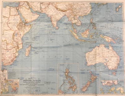
Sold2018Indian Ocean Map 1941Indian Ocean Map : Australia, New Zealand and Malaysia. National Geographic magazine. Date: 1941. Editor: Gilbert Grosvenor. Measurement approximate: 25 x 32. Shipping cost: $15.00 excluding Hawaii, ASee Sold Price
Sold2020Vintage National Geographic Magazine map of the IndianDescription: Vintage color paper map from National Geographic Magazine depicting the Indian Ocean. Copyright 1941. Material: paper. Measurement: approximate 26.5"h x 34"w (INCHES). Shipping cost: $12;See Sold Price
Sold2020Framed Indian Ocean MapIndian Ocean map featuring whaling routes and marked J. S. Hobbs in a plexiglass-glass frame. Condition: excellent. call for additional condition report.Size: 83in x 48inSee Sold Price
Sold2017Tallis: Map of Islands in the Indian Ocean, 1851Map: Islands in the Indian Ocean Cartographer: Tallis Place & Date: London/New York / 1851 Size: 13 1/4" x 10 1/2" The superb Indian Ocean islands map from Tallis' Illustrated Atlas extending from theSee Sold Price
Sold2024World Map - Course of Trade Winds Map - Indian Ocean - Atlantic Ocean - from "Histoire Generale deHand-coloured Historic Map "Representation du Cours ordinaire des Vents de Traverse qui regnent le long des Cotes dans la Mer Atlantique & Celle des Indes" charging the course of the trade winds in thSee Sold Price
Sold2018INDIAN OCEAN. British colonies/Empire. Winds currentsTITLE/CONTENT OF MAP: 'Indian Ocean on Mercator's Projection' DATE PRINTED: 1920 IMAGE SIZE: Approx 34.0 x 45.0cm, 13.25 x 17.5 inches (Large) TYPE: Vintage colour map CONDITION: Good; suitable for frSee Sold Price
Sold20191792 Elwe Map of Indian Ocean Islands -- Parte de laTitle: 1792 Elwe Map of Indian Ocean Islands -- Parte de la Nouvelle Grande Carte des Indes Orientales, Contenant les Isles Maldives, Ceylan, Malacca, Sumatra &c. Avec Les Terres Adjacentes De CouchinSee Sold Price
Sold2017Antique framed map of Indian Ocean, Asia, AustraliaTitle/Content of Map: Antique framed map of Indian Ocean, Asia, Australia Date Printed: 1713 Cartographer: Aa, Pieter van der Size (in): 11 x 8 Very attractive framed copper-engraved antique map by PiSee Sold Price
Sold20222 PC. FRAMED EARLY MEDITERRANEAN MAPS2 PC. FRAMED EARLY MEDITERRANEAN MAPS: Comprising; 1- 1658 Jansson Map of the Indian Ocean. 1- This historical map illustrates the region involved in the conquest of Cyrus the Great (558-528 BC), theSee Sold Price
Sold2018Reclus, Elisee C1880 Lot of 28 Wood Eng Maps, GoodIncl Australia, Tasmania, New Zealand, Philippines, Reunion, Madeira, Madagascar, Indian & Pacific Ocean. Wood Engraved Maps with surrounding and verso text. Published 1875-94, Paris for "La NouvelleSee Sold Price
Sold2022Mannevillette French Map of the Indian Ocean, 1753D'APRES DE MANNEVILLETTE, Jean-Baptiste-Nicolas-Denis (1707-1780). [Indian Ocean] Carte Reduite de l'Ocean Oriental depuis le Cap de Bonne Esperance... Engraved map with original hand color in part. PSee Sold Price
Sold2023Pursuit of SMS Emden August-Nov 1914. Indian Ocean. First World War. 1920 mapOperations against S. M. S. Emden August to November 1914 [Battle of Cocos]. Map compiled by Sir Julian Stafford Corbett. Published by Ordnance Survey 1919 (1920). Antique military history map, 58.5 xSee Sold Price
Sold2022Brockhaus (Pub) 1890's Lot of 20 Antique MapsIncl Mozambique, Italy, Portugal, Germany, Japan, France, Indian Ocean, Wind Chart, etc. Lithograph Maps Published 1892-98 by F. A. Brockhaus, Leipzig for "Brockhaus' Konversations-Lexikon" by VariousSee Sold Price
Sold2022Colom's Map of the Western Indian Ocean, c. 1658COLOM, Arnold (1624-1668). Oost Indien van Cabo de Bona Esperanca tot Ceilon. Engraved map with original hand color in outline. Amsterdam, c. 1658. 22 1/4" x 25 1/2" sheet. Colom's Zee Atlas is amongSee Sold Price
Sold2021Tallis, John (Pub) 1852 Map Islands in the Indian OceanSteel Engraved Map with Original Outline Hand Color Published 1852-56 by John Tallis, London for "The Universal Pronouncing Dictionary" by Thomas Wright. Drawn & Engraved by John Rapkin. Centre fold aSee Sold Price
Sold2019INDIAN OCEAN Madagascar Seychelles Maldives MauritiusReserve Reduced! TITLE/CONTENT OF MAP: 'ISLANDS IN THE INDIAN OCEAN. Madagascar, Amirantes, Seychelle Archipelago, Socotra, Lakadive Islands, Maldive Islands, Andaman Isles, Nicobar Isles, Chagos GrouSee Sold Price
Sold20211749 Robert de Vaugondy Map of Madagascar and IndianTitle: 1749 Robert de Vaugondy Map of Madagascar and Indian Ocean Islands -- Isle de Madagascar ou de St. Laurent et Isles Circonvoisines Cartographer: D. Robert de Vaugondy Year / Place: 1749, ParisSee Sold Price
2016Large Vintage Fabric Printed Map of IndonesiaLarge Vintage Fabric Printed Map of Indonesia & the Indian Ocean. Mid 20th century. Measures 42 x 84 inches.See Sold Price
Sold2016Large Vintage Fabric Printed Map of IndonesiaLarge Vintage Fabric Printed Map of Indonesia & the Indian Ocean. Mid 20th century. Measures 42 x 84 inches.See Sold Price
Sold2019Bartholomew, John 1922 Lot of 4 Maps. Oceans & WorldIncl North & South Atlantic, Indian Ocean and World Commerce. Large Lithograph Maps Published 1922 by The Times, London for "The Times Survey Atlas of the World" Maps by John George Bartholomew of theSee Sold Price
Sold2021Vents de Traverse. Atlantic & Indian Ocean trade winds.TITLE/CONTENT OF MAP: 'Répresentation du cours ordinaire des Vents de Traverse, qui règnent le long des côtes dans la Mer Atlantique & celle des Indes [Representation of the normal course of the trSee Sold Price
Sold2018SDUK: Map of Asia & Australia on Gnomonic ProjectionTitle/Content of Map:'WORLD ON GNOMONIC PROJECTION, IV, Asia.' Cotidal lines are marked on the map. ASIA AUSTRALIA. On Gnomonic Projection. China Indian Ocean. Date Printed: 1846 Image Size: Approx 32See Sold Price
Sold2020Bartholomew, John 1922 Lot of 5 Maps of the OceansIncl North Atlantic, Indian Ocean, North Pacific, South Pacific and South Atlantic. Large Lithograph Maps Published 1922 by The Times, London for "The Times Survey Atlas of the World" Maps by John GeoSee Sold Price
Sold2019Bartholomew, John 1922 Mixed Lot of 9 Large MapsIncl Mapping of the World, World Climate, Germany East, Southern Russia, Asia Minor/Syria/Mesopotamia, Palestine, Indian Ocean, North America - Political, North Atlantic Ocean. Large Lithograph Maps PSee Sold Price
Jun 07Freeman's | HindmanBELLIN, Jacques-Nicolas. Carte Reduite de L'Ocean Oriental ou Mer Des Indies. Paris, 1757. Second$150
16 hrs LeftHannam's Auctioneers LtdA LARGE 19TH CENTURY COCO DE MER COUNTRY HOUSE NUT CASKET AND COVER of naturalistic form. 28 cm x 28£260(1 bid)
1 day LeftJasper52SOUTH WEST ASIA. Persia Afghanistan Baluchistan.Pakistan.British India 1920 map$20(1 bid)
4 days LeftMichael's GalleryJorn Fox (1941 Indian Motorcycle) Signed Original Oil - Impressionist$100
Jun 12Dan Morphy AuctionsPLATE CXIII. MAP OF INDIAN TERRITORY SHOWING DISTRIBUTION OF WOODLAND” FROM THE TWENTY-FIRST$100


![Mannevillette French Map of the Indian Ocean, 1753: D'APRES DE MANNEVILLETTE, Jean-Baptiste-Nicolas-Denis (1707-1780). [Indian Ocean] Carte Reduite de l'Ocean Oriental depuis le Cap de Bonne Esperance... Engraved map with original hand color in part. P](https://p1.liveauctioneers.com/1968/250616/130196497_1_x.jpg?height=310&quality=70&version=1654190895)
![Pursuit of SMS Emden August-Nov 1914. Indian Ocean. First World War. 1920 map: Operations against S. M. S. Emden August to November 1914 [Battle of Cocos]. Map compiled by Sir Julian Stafford Corbett. Published by Ordnance Survey 1919 (1920). Antique military history map, 58.5 x](https://p1.liveauctioneers.com/5584/306990/164073697_1_x.jpg?height=310&quality=70&version=1698786195)


