Sold2016Instructions to Surveyor General of Oregon 1851Heading: Author: Moore, John M. Title: Instructions to the Surveyor General of Oregon; Being a Manual for Field Operations Place Published: Washington Publisher:Gideon & Co., Printers Date PubliSee Sold Price
Sold2022MS. plat map of S.F. Pueblo Lands 1884Heading: -1884 Author: von Leicht, Ferdinand Title: Plat of the Pueblo Lands of San Francisco finally confirmed to the City of San Francisco Surveyed under instructions from the U.S. Surveyor GeneralSee Sold Price
Sold2022Plat of the Pueblo Lands of San Francisco 1884Heading: -1884 Author: von Leicht, Ferdinand Title: Plat of the Pueblo Lands of San Francisco finally confirmed to the City Of San Francisco. Surveyed under instructions from the U.S. Surveyor GeneralSee Sold Price
Sold2018(I) Map of Louisiana Representing the Several LandTitle: (I) Map of Louisiana Representing the Several Land Districts... Publication Date: 1851-10-25 Cartographer: BOYD, R.W. (SURVEYOR GENERAL, LA) Publisher: BOYD, R.W. Size: 15 X 16.5 Prepared to acSee Sold Price
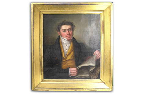
Sold2022JOHN F. FRANCIS OIL ON CANVAS PORTRAIT OF SURVEYOR GENERAL JOHN MYERSJOHN F. FRANCIS OIL ON CANVAS PORTRAIT OF SURVEYOR GENERAL JOHN MYERS. 37" X 34"John F. Francis (August 13, 1808 – November 15, 1886) was an American painter, primarily of still lifes.BiographySee Sold Price
Sold2022(KOLKATA.) Indian Surveyor General's Office. Plan of the Town of Calcutta.(KOLKATA.) Indian Surveyor General's Office. Plan of the Town of Calcutta. Large hand-colored lithographed case map offering a substantial amount of 19th-century city detail. 51x41 inches overall, segSee Sold Price
Sold2023Letter to Surveyor General John Coffee Hays from San Francisco Treasury Comptroller, 18547.75" x 10.25". Onion skin paper dated October, 1854. Letter to John Coffee Hays as Surveyor General of California explaining an error in accounting. One page of a two page letter. **Good condition. SSee Sold Price
Sold20224 Lefton Military Figurines: 1813 General, 1851 Musician & Cadet, 1813 Infantry, Lefton LineDescription: 4 Lefton Military Figurines: 1813 General, 1851 Musician & Cadet, 1813 Infantry, Lefton Line Officer Measurement approximate: 7 H (Inches). MaterIal: Ceramic.See Sold Price
Sold2017Williams: Antique Pocket Map on New York State, 1828Map: 1828 Williams Pocket Map on New York State -- The Tourist's Map of the State of New York Compiled from the Latest Authorities in the Surveyor General's Office Cartographer: W. Williams Year / PlaSee Sold Price
Sold2021Map of Public Surveys in California to Accompany ReportPublication Date: 1862 Title: Map of Public Surveys in California to Accompany Report of Surveyor Genl. 1862. Cartographer: U.S. SURVEYOR GENERAL FOR CALIFORNIA Publisher: HOUSE OF REPRESENTATIVES HeiSee Sold Price
Sold2023Sketch of Public Surveys in New Mexico...DescriptionTitle: Sketch of Public Surveys in New Mexico...Publication Date: 1863Cartographer: CLARK, JOHN A.Publisher: SURVEYOR GENERAL OF NEW MEXICOHeight: 18.3Width: 17.4Map showing townships subdiSee Sold Price
Sold2021Map of a Part of Washington Territory to AccompanyPublication Date: 1861Title: Map of a Part of Washington Territory to Accompany Report Of the Surveyor General 1860-'61. Cartographer: TILTON, JAMES Publisher: SURVEYOR GENERAL Height: 22 Width: 28 MaSee Sold Price
Sold2020Map of Ocracoke InletTitle/Content of Map: Map of Ocracoke Inlet Cartographer: DUTTON, GEORGE/ALEXANDER JOSEPH SWIFT Date: c1837 Publisher: SURVEYOR GENERAL'S OFFICE ? Size: 12.5Height - 18Width "as compiled by Lieut DuttSee Sold Price
Sold2017Daniel Brodhead Signed DocumentDESCRIPTION: Document signed by Daniel Brodhead as Surveyor General, [Philadelphia], January 5, 1798, attesting to the authenticity of a land warrant written on March 4, 1793 for four hundred thirty-tSee Sold Price
Sold2020T Sketch of Public Surveys in New Mexico.Title/Content of Map: T Sketch of Public Surveys in New Mexico. Publication Date: 1856 Cartographer: PELHAM, WILLIAM Publisher: SURVEYOR GENERAL'S OFFICE Description: "To accompany report of surveyorSee Sold Price
Sold2020Diagram of the State of MissouriTitle/Content of Map: Diagram of the State of Missouri Cartographer: W.J. STONE, SC. WASH. Date: 1839 Publisher: WILLIAMS, MILBURN/SURVEYOR GENERAL (MO) Size: 19Height - 23Width Map shows survey grid,See Sold Price
Sold2021(No.2.) Sketch of the Public Surveys in IowaTitle: (No.2.) Sketch of the Public Surveys in Iowa Catographer: LEWIS, WARNER Publisher:SURVEYOR GENERAL'S OFFICE Dimensions: 17.5 x 20.75 Additional Information:Shows all rivers. (33th Cong., 2d sesSee Sold Price
Sold2016Michigan Showing Districts Embraced by Contracts, 1849Map: P Diagram of the State of Michigan Showing the Districts Embraced by Contracts for Subdivisions North of Grand and Saganaw Rivers Cartographer: L Lyon / Michigan Surveyor General's Office PublishSee Sold Price
Sold20231855 Sketch of Kansas & Nebraska Including Indian Lands in the 19th C1855 Sketch of Kansas & Nebraska Including Indian Lands in the 19th C MEDIUM: Printed on Paper DIMENSIONS: Sight 12 x 20.25 inches CIRCA: Published Nov. 8, 1855 ATTRIBUTION: Surveyor General's OfficeSee Sold Price
Sold2022Early Georgia Manuscript Land SurveySurveyor General's Office, Milledgeville, Georgia, July 22, 1858. Folio sheet. A partially printed document completed in manuscript, being a true copy of a late 18th century land survey in Wilkes CounSee Sold Price
Sold2023Untitled. [River Systems of Southern Wisconsin]Publication Date: c1855 Title: Untitled. [River Systems of Southern Wisconsin] Cartographer: ANONYMOUS Publisher: SURVEYOR GENERAL'S OFFICE Height: 13 Width: 15 Original coloring. Browned. Lower margiSee Sold Price
Sold2019GLO Map of Washington Territory, ca 1860-61**Originally Listed At $100** Map of a Part of Washington Territory to Accompany the Report of the Surveyor General 1860-61. A very collectible early survey map of the Washington Territory that was coSee Sold Price
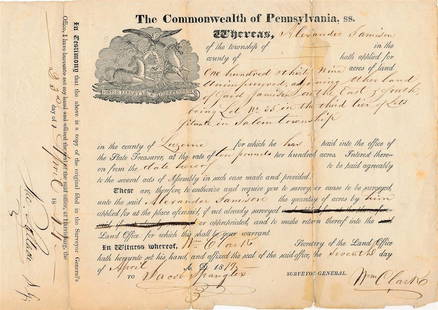
Sold20221819 Pennsylvania Document Signed by Jacob Spangler & William ClarkHistorical 9.5X5 Commonwealth of Pennsylvania document from 1819 purchase of land signed by Jacob Spangler as Surveyor General and William Clark as Secretary of the Land Office. Very nice.Jacob SpanglSee Sold Price
Sold2017Florida Lithograph MapA Plat Exhibiting The State of the Surveys in the State of Florida. US Surveyor General. Lithograph. Washington D.C. : 1855. 22 1/2 x 26 inches visible, 35 x 38 inches framedSee Sold Price
Jun 13Forum AuctionsIreland & Scotland.- House of Commons. A list of the members of the Hon. House of Commons of£50
3 days LeftEarly American History AuctionsWar of 1812 Partly-printed Muster Roll Massachusetts Militia of General William Donnison$280
Jun 15Hess Fine AuctionsImportant Tiffany & Co. 1934 West Point WWII US Army Hero General Loyd Elmer Fellenz Ring$250(5 bids)
Jul 07A-1 AuctionBarry Stein Oregon Artist Bronze Sculpture "The Last Samurai" Japanese Warrior 4/90 Casting$250(5 bids)
Jun 22Check the Oil Promotions, LLCGeneral Motors OK Used Cars Dealership Porcelain Neon Sign SSP$425(4 bids)


![Daniel Brodhead Signed Document: DESCRIPTION: Document signed by Daniel Brodhead as Surveyor General, [Philadelphia], January 5, 1798, attesting to the authenticity of a land warrant written on March 4, 1793 for four hundred thirty-t](https://p1.liveauctioneers.com/446/112579/57799934_1_x.jpg?height=310&quality=70&version=1511016662)


![Untitled. [River Systems of Southern Wisconsin]: Publication Date: c1855 Title: Untitled. [River Systems of Southern Wisconsin] Cartographer: ANONYMOUS Publisher: SURVEYOR GENERAL'S OFFICE Height: 13 Width: 15 Original coloring. Browned. Lower margi](https://p1.liveauctioneers.com/5584/281528/148418731_1_x.jpg?height=310&quality=70&version=1678826634)


![Across America, Rusling, 1875 [181941] (1 of 9)](https://p1.liveauctioneers.com/2699/331494/178785461_1_x.jpg?height=282&quality=70&version=1717189774)


