Sold2019Japan C1880 Pair of Maps by Nolan & Blackie"The Islands of Japan with Corea..." Steel Engraved Map Published C1880, London for "The Illustrated History of the British Empire in India and the East" by Edward H. Nolan. Centre fold as published.See Sold Price
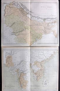
Sold2021Nolan, Edward C1880 Pair of Maps of India"India. The Bombay Presidency/India. The Madras Presidency" and "India The Bengal Presidency" Steel Engraved Map Published C1880, London for "The Illustrated History of the British Empire in India andSee Sold Price
Sold2019Blackie & Weller 1882 Pair of Maps of China"China" and "The Chinese Empire and Japan" Lithograph Maps Published 1882 by Blackie & Son, London for "The Comprehensive Atlas & Geography of the World" by W. G. Blackie. Maps by Edward Weller. CentrSee Sold Price
Sold2021Nolan, Edward C1880 Lot of 3 Maps. China, Japan, AsiaSteel Engraved Map Published C1880, London for "The Illustrated History of the British Empire in India and the East" by Edward H. Nolan. Centre fold as issued. Paper Size: 12 x 10 inch (30 x 25cm) GooSee Sold Price
Sold2022Encyclo. Britannica C1880 Pair of Maps of New York & NY CityLithograph Maps Published 1875-98, Edinburgh & London for "Encyclopaedia Britannica" Ninth Edition. Paper Size: 16 x 11 inch (40 x 28cm) Good ConditionSee Sold Price
Sold2022Reclus, Elisee C1880 Pair of Maps of IndiaLithograph Maps Published 1876-94, London for "The Universal Geography" by Elisee Reclus. Edited by A. H. Keane. Folds as issued. Paper Size: 14 x 10.5 inch (36 x 27cm) Approx. Good ConditionSee Sold Price
Sold2018India 1882 Pair of Maps by BlackieLithograph Maps Published 1882 by Blackie & Son, London for "The Comprehensive Atlas & Geography of the World" by W. G. Blackie. Paper Size: 22 x 15 inch (56 x 38cm) Small margin tear to one. Good conSee Sold Price
Sold2019China & Japan 1895-1920 Pair of Maps. Gross, TimesLarge Lithograph Map Published 1920, London for "The Daily Telegraph Victory Atlas of the World" by Alexander Gross. Centre fold as published. Also One other Published 1895, London for "The Times AtlaSee Sold Price
Sold20191884 Blackie Map of Japan -- JapanTitle: 1884 Blackie Map of Japan -- Japan Date: 1884, London Cartographer: W Blackie Size:13.4 X 10.3 in. Description: This is an attractive map of Japan. Plenty of detail is offered as to topography,See Sold Price
Sold2021Nolan, Edward C1880 Map of The East India IslandsSteel Engraved Map Published C1880, London for "The Illustrated History of the British Empire in India and the East" by Edward H. Nolan. Centre fold as issued. Paper Size: 12 x 10 inch (30 x 25cm) GooSee Sold Price
Sold2019Nolan, Edward C1880 Map of The Eastern HemisphereSteel Engraved Map Published C1880, London for "The Illustrated History of the British Empire in India and the East" by Edward H. Nolan. Centre fold as published. Paper Size: 12.5 x 9.5 inch (32 x 24cSee Sold Price
Sold2021Nolan, Edward C1880 Map of Eastern HemisphereSteel Engraved Map Published C1880, London for "The Illustrated History of the British Empire in India and the East" by Edward H. Nolan. Centre fold as issued. Paper Size: 12 x 10 inch (30 x 25cm) SmaSee Sold Price
Sold2019Blackie & Weller 1882 Pair Maps of USA & North America"The United States of North America, Pacific States" and "North America" Lithograph Maps Published 1882 by Blackie & Son, London for "The Comprehensive Atlas & Geography of the World" by W. G. BlackieSee Sold Price
Sold2019Bartholomew, John 1922 Pair of Maps of JapanLarge Lithograph Maps Published 1922 by The Times, London for "The Times Survey Atlas of the World" Maps by John George Bartholomew of the Edinburgh Geographical Institute. Centre fold as issued. PapeSee Sold Price
Sold2023Brockhaus (Pub) 1890's Pair of Maps of Japan. Tokyo & YokohamaLithograph Maps Published 1892-98 by F. A. Brockhaus, Leipzig for "Brockhaus' Konversations-Lexikon" by Various. Paper Size: Up to 10 x 6 inch (25 x 16cm) Approx. Good ConditionSee Sold Price
Sold2022Times Atlas 1895 Pair of Maps. China & JapanLithograph Maps Published 1895, London for "The Times Atlas" Paper Size: 16 x 10.5 inch (41 x 27cm) Good ConditionSee Sold Price
Sold2020Bartholomew, John 1922 Pair of Maps of JapanLarge Lithograph Maps Published 1922 by The Times, London for "The Times Survey Atlas of the World" Maps by John George Bartholomew of the Edinburgh Geographical Institute. Centre fold as issued. PapeSee Sold Price
Sold2021Nolan, Edward C1880 Decorative Map of IndiaSteel Engraved Map Published C1880, London for "The Illustrated History of the British Empire in India and the East" by Edward H. Nolan. Centre fold as issued. Paper Size: 12 x 10 inch (30 x 25cm) GooSee Sold Price
Sold2023Nolan & Hughes C1880 Antique Map. Eastern HemisphereLithograph Map Published C1880, London for "The Illustrated History of the British Empire in India and the East" by Edward H. Nolan. Centre fold as issued. Drawn by W. Hughes. Paper Size: 12 x 10 inchSee Sold Price
Sold2019Blackie & Weller 1882 Pair of Maps of IndiaIndia and India South Part. Lithograph Maps Published 1882 by Blackie & Son, London for "The Comprehensive Atlas & Geography of the World" by W. G. Blackie. Maps by Edward Weller. Centre fold as issueSee Sold Price
Sold2022Reclus, Elisee C1880 Antique Map of Tokyo, JapanLithograph Maps Published 1876-94, London for "The Universal Geography" by Elisee Reclus. Edited by A. H. Keane. Centre fold as issued. Paper Size: 13 x 10 inch (33 x 25cm) Approx. Good ConditionSee Sold Price
Sold2019Bartholomew, John 1922 Pair of Large Maps of JapanLarge Lithograph Map Published 1922 by The Times, London for "The Times Survey Atlas of the World" Maps by John George Bartholomew of the Edinburgh Geographical Institute. Centre fold as issued. PaperSee Sold Price
Sold2022A PAIR OF NOLAN MILLER AND TIMEX WRIST WATCHESA pair of Nolan Miller and Timex wrist watches. The Nolan Miller stainless steel, Japan movement, watch, and a bracelet from the Glamour collection. Both items are made in unique design and inlaid witSee Sold Price
Sold2018Blackie & Weller 1882 Mixed Lot of 5 MapsIncl Japan, France, Central Europe, Spain and Portugal, Brazil. Lithograph Maps Published 1882 by Blackie & Son, London for "The Comprehensive Atlas & Geography of the World" by W. G. Blackie. Maps bySee Sold Price
Jun 15Riverfront AuctionsMaps of the Miami Canal and Spring Grove, Avondale & Cincinnati Railway Deed$5(1 bid)
1 day LeftCambi Casa D'AsteRare pair of cloisonné Moon Flask with samurai and duck figures in pond, winter landscape, Japan,€2,000
Jun 15Crescent City Auction GalleryPair of New Orleans Sanborn Fire Insurance Mock-Up Skeleton Maps of the French Quarter, 1910-1911,$250
4 days LeftTrillium Antique Prints & Rare BooksSanson - Map of California as an Island, Mexico (Audience de Guadalajara)$160(4 bids)
4 days LeftTrillium Antique Prints & Rare BooksSanson - Map of North America with California as an Island$120(3 bids)
4 days LeftTrillium Antique Prints & Rare BooksCatesby, Folio - Pair of Squirrel Engravings$200(1 bid)
6 days LeftAdam's AuctioneersA PAIR OF MARQUETRY INLAID MAHOGANY SETTEES BY JAMES SHOOLBRED, TOTTENHAM COURT, LONDON, C.1880€500
4 days LeftTrillium Antique Prints & Rare BooksDavid Roberts - Pair of Lithographs of Views of Nubia$100
1 day LeftCambi Casa D'AstePair of Arita porcelain vases with Imari decoration, Japan, early 18th century€300