Sold2017Jerusalem (and Surrounding Area) MapJerusalem (and surrounding area), 14.5 x 10.5 in, c. 1881, Hardesty Please note that this lot has a confidential reserve. When you leave a bid in advance of the auction, submit your maximum. Jasper52See Sold Price
Sold2022Chattanooga & Surrounding area hanging mapvery detailed - clear plastic protedted 37" x 37" scale 1" equals 0.736 miles The Way Map Co., of ChattanoogaSee Sold Price
Sold2020Gerardus Mercator Map of Macedonia ca. 1595Gerardus Mercator (1512–1594), "Macedonia Epirus et Achaia," Amsterdam, ca. 1595. Hand colored map of Macedonia and the surrounding areas. This map features beautifully executed topographical dSee Sold Price
Sold2019Paris monumental Paris: A. Taride, Folding, color mapMaps, France, Paris) Paris monumental [cover title] Paris: A. Taride, n.d. 4pp text. Folding, color map (22 x 27 1/2"), map of area surrounding Paris on verso. Tipped into original gilt-decorated clotSee Sold Price
Sold2020India and surrounding areas. European colonialTitle: India and surrounding areas. European colonial expansion map. Date/Period: 1732-1736 Materials: Copperplate engraved. Size: 17 1/4 x 9” Centered on India. A unusual geographic assembly from ASee Sold Price
Sold2021EDDY, Gerald. Lake Tahoe / California-Nevada. Reno:EDDY, Gerald. Lake Tahoe / California-Nevada. Reno: Silver State Press, 1965. Offset lithograph birds-eye map of the area surrounding Lake Tahoe, looking east, showing Reno, Sparks, and Carson City, mSee Sold Price
Sold2023Map of the Country between Crown Point and Fort EdwardA Map of the Country between Crown Point and Fort Edward, published 1759, hand color, (4.5" x 7.5"). This map depicts the area surrounding Lake George, along the northeastern border of New York state,See Sold Price
Sold20211736 large French map of Paris and surrounding areaLarge engraving of Paris and its surrounding area dated 1736 , cooper engraving in the manner of the Turgot map , name of printer not lisible ,the date is clear . H.23 1/4 x W. 36 , suitable for framiSee Sold Price
Sold202126 Books, Pamphlets Japanese Art & AntiquesIncludes a map of Hachinohe and surrounding areas. Multiple books on Japanese woodblock artist and prints, Osaka, Hokusai, Chinese paintings, ceramics. Dimensions are: Largest book: 15 1/2 inches tallSee Sold Price
Sold2023BRYAN. Boy Scouts’ Coming-of-Age World Jamboree. 1929. Lond...BRYAN. Boy Scouts’ Coming-of-Age World Jamboree. 1929. London: George Falkner & Sons Ltd. Pictorial map of England showing the area surrounding Arrowe Park, where some 40,000 scouts from 41 counSee Sold Price
Sold2023APRIL 24, 1944 MUNICH BOMBING MAP AND BOMB RELEASE BUTTONBritish War Office 1:500,000 scale air map of Munich and the surrounding area, 28 x 24 in., originally compiled and drafted at the War Office in 1940, this second edition dated 1942. This perticular mSee Sold Price
Sold2022(ROME.) Filippo Trojani. Carta Topografica del Suburbano di Roma.(ROME.) Filippo Trojani. Carta Topografica del Suburbano di Roma. Large engraved map of Rome and its surrounding area. 46x41½ inches overall, segmented and mounted to original linen backing; fainSee Sold Price
Sold20191803 Map of Gibraltar Fortifications1803 map of Gibraltar Bay and Surrounding area, published by Cadell and Davies, London, 1803. Fine, measures 8.25 x 10.5". Reserve: $20.00 Shipping: Domestic: Flat-rate of $5.00 to anywhere within theSee Sold Price
Sold2022(PHILADELPHIA.) Nicholas Scull; and George Heap. A Map of Philadelphia and Parts Adjacent.(PHILADELPHIA.) Nicholas Scull; and George Heap. A Map of Philadelphia and Parts Adjacent. Engraved folding map of the city and surrounding areas along the Delaware and Schuylkill Rivers. 16x14 inchesSee Sold Price
Sold2021(PHILADELPHIA.) Nicholas Scull; and George Heap. A Map(PHILADELPHIA.) Nicholas Scull; and George Heap. A Map of Philadelphia and Parts Adjacent. Engraved folding map of the city and surrounding areas along the Delaware and Schuylkill Rivers. 14½x12See Sold Price
Sold2022Lodge's Rev. War map, ext. scarce 1870 reprintExtremely scarce reprint of the original 1781 map by John Lodge and John Bew. Uncommon Revolutionary War map showing the defenses for New York and the surrounding area, including Staten and Long islanSee Sold Price
Sold20241812 large French map of Paris plan routier de la Ville et faubourgLarge engraving of Paris and its surrounding area dated 1812 , cooper engraving in the manner of the Turgot map ,Jean Pierre printer , a Paris, chez Jean, Rue St Jean de Beauvais, N° 10, It is thSee Sold Price
Sold2023USC&GS Map, Marth's Vineyard to Block Island, MassachusettsA color map going from Martha's Vineyard to Block Island and the surrounding area. Publishing stamp by "The U.S Coast and Geodetic Survey" located on bottom. Issued: 1941 Dimensions: 46"L x 36"W ManufSee Sold Price
Sold2020John Speed Map of the Turkish Empire 1626John Speed (ca. 1551-1629) "The Turkish Empire," London: G. Humble, 1626. This hand-colored map of what is now Turkey and the surrounding areas features a detailed border along the top edge of inset mSee Sold Price
Sold2020Pierre Duval Nova Mexico Map ca. 1660 CaliforniaPierre Duval (1618-1683), "Nova Mexico," Nuremberg, ca. 1660-1680. This rare map depicts California as an island, based on Sanson's depiction, along with the surrounding areas of Mexico and what is noSee Sold Price
Sold2021BRITISH MAP OF ENGLAND AND WALES NEEDLEWORK SAMPLERBRITISH MAP OF ENGLAND AND WALES NEEDLEWORK SAMPLER, silk on linen, oval vignette featuring the map of England and Wales with counties outlined and named, surrounding areas named including Scotland, ISee Sold Price
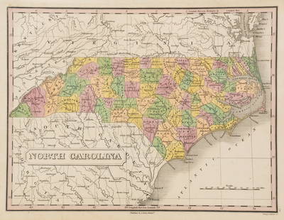
Sold2023Anthony Finley North Carolina Counties MapA Anthony Finley (American, 1784-1834) handcolored engraving depicting the counties within North Carolina and the surrounding areas. Stamped 'Published By A. Finley Phliad.' lower center. Presented inSee Sold Price
Sold2024Pittsburgh Plat Map Shadyside Fifth and WilkinsPlat Map of the Shadyside neighborhood of Pittsburgh, showing the triangular intersection of Wilkins and Fifth Avenues and surrounding areas, including parts of Walnut St., Dunmoyle and Beeler, c.1910See Sold Price
Jun 13Swann Auction Galleries(NEW YORK CITY.) G.W. Colton; and J.M. Atwood. Map of the Country Thirty Three Miles Around the City$600
Jun 23Schilb Antiquarian Rare Books1870 BEAUTIFUL Life of Jesus Christ Fleetwood Bible ART Miracles Jerusalem Map$72(4 bids)
Jun 23Schilb Antiquarian Rare Books1790 Life of Jesus Christ Fleetwood Bible ART Miracles Jerusalem MAP Holy Land$80(4 bids)
6 days LeftThe North Georgia Auction Company LLCClint Alderman Edgefield Area Potteries Map$200(1 bid)
1 day LeftJasper521893 Civil War Map of Knoxville Area -- Topographical Map of the Approaches and Defences of$70
Jun 13Swann Auction Galleries(TRI-STATE AREA.) A.R. Ohman Map Co. Map Showing 100 Miles Around New York City.$450
1 day LeftJasper521852 Evans Map of the Badlands -- Map Showing the Position of the Bad Lands or Mauvaises Terres of$60
Jun 20Weatherham Estate Treasures6" x 6" Framed Male "The Blue Peacock" Butterfly - Papilio Arturus$94
Featured1 day LeftJasper521758 Akerman Map of Germanic States -- Area Belli Germanici Praesentis…$80


![Paris monumental Paris: A. Taride, Folding, color map: Maps, France, Paris) Paris monumental [cover title] Paris: A. Taride, n.d. 4pp text. Folding, color map (22 x 27 1/2"), map of area surrounding Paris on verso. Tipped into original gilt-decorated clot](https://p1.liveauctioneers.com/5584/134625/68366133_1_x.jpg?height=310&quality=70&version=1547591614)


![Pacific Electric RY Co. pass, 1911 [179507] (1 of 2)](https://p1.liveauctioneers.com/2699/331495/178786097_1_x.jpg?height=282&quality=70&version=1717094933)
![Pacific Electric RY Co pass, 1913 [179506] (1 of 2)](https://p1.liveauctioneers.com/2699/331495/178786096_1_x.jpg?height=282&quality=70&version=1717094933)


