Sold2023La Mappe Monde- Map of 3 Voyages of Captain CookAntique Map Print- La Mappe Monde, Depicting the Three Voyages of Captain Cook. Original was Drawn by Herisson, Hand Watercolored, Number 64 and Dated 1816. Measures 33 1/2" x 47" framed. Good ConditiSee Sold Price
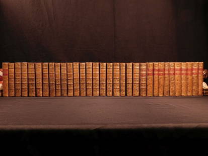
Sold20181780 1ed RARE Complete VOYAGES Maps Captain Cook Americ1780 1ed RARE Complete VOYAGES Maps Captain Cook America Explorers Africa 32v The best book of its kind! An extremely rare, 32-volume complete set of La Harpe’s ‘General History of Voyages’! ThiSee Sold Price
Sold20181780 1ed RARE Complete VOYAGES Maps Captain Cook1780 1ed RARE Complete VOYAGES Maps Captain Cook America Explorers Africa 32v The best book of its kind! An extremely rare, 32-volume complete set of La Harpe’s ‘General History of Voyages’! ThiSee Sold Price
Sold20181780 1ed VOYAGES Captain Cook Maps Comm Byron America1780 1ed VOYAGES Captain Cook Maps Comm Byron America Explorers Africa 3v La Harpe The best book of its kind! A rare set of La Harpe’s ‘General History of Voyages’! This extensive work was begunSee Sold Price
Sold20191785 Engraving from "Third Voyage of Captain Cook"1785 Antique Engraving from "Third Voyage of Cook" by Benard Drexit, 28 x 43 cm."VUES DE LA COTE OCCIDENTALE D'AMERİQUE.A map of American costal.See Sold Price
Sold2015Lg Framed early 19th c. Map of the WorldLg Framed early 19th c. Map of the World, "Mappe Monde", Indication des trois voyages du Capitaine Cook, French 1816 in floral gilt 32" x 46" frame Condition; was folded, some wear along fold lines frSee Sold Price
Sold20241842 VOYAGES OF CAPTAIN JAMES COOK 2 VOLUMES antique ILLUSTRATEDThe Voyages of Captain James Cook London: William Smith, 1842 2 volumes Size 7 by 9 3/4" Additional engraved title in volume I, engraved frontispieces, double-page maps, in-text vignettes, etc. MinorSee Sold Price
Sold2022c. 1781 Captain Cook Voyages Map, London by Alexander HoggHistoric Maps "A Plan of Success Bay in Strait Le Maire / A Chart of the S.E. part of Terra del Fuego... by Captn. Cook 1769" c. 1781, A "Dual" Map from Captain Cook's Voyages, titled: "A Plan of SuccSee Sold Price
Sold2022c. 1781 Captain Cook Voyages Map, London by Alexander HoggHistoric Maps "A Plan of Success Bay in Strait Le Maire / A Chart of the S.E. part of Terra del Fuego... by Captn. Cook 1769" c. 1781, Dual Map from Captain Cook's Voyages, titled: "A Plan of SuccessSee Sold Price
Sold20221836 1ed Oceania Rienzi Polynesia Voyages MAPS Australia Captain Cook Pacific1836 1ed Oceania Rienzi Polynesia Voyages MAPS Australia Captain Cook Pacific Louis de Rienzi was a 19th-century French voyager who is remembered for his 1836 masterwork Oceania, or Fifth Part of theSee Sold Price
Sold20191836 1ed Oceania Rienzi Polynesia Voyages MAPS1836 1ed Oceania Rienzi Polynesia Voyages MAPS Australia Captain Cook Pacific Louis de Rienzi was a 19th-century French voyager who is remembered for his 1836 masterwork ‘Oceania, or Fifth Part of tSee Sold Price
2017Tallis/Rapkin: Antique Map of Captain Cook's VoyageTitle/Content of Map: 'The World on Mercator's Projection shewing the voyages of Captain Cook around the World' The track's of Cook's first, second and third voyages are shown, along with dates. DateSee Sold Price
Sold2022Voyages CAPTAIN COOK Huts in New Zealand 1840 engravingVoyages du CAPITAINE COOK huttes des habitants de la Nouvelle Zelande, french 1840 engraving, from Bibliotheque des Voyages Anciens et Modernes published in 1840 in Paris.5 1/2" X 8 1/4”.DimensiSee Sold Price
Sold2022Voyages CAPTAIN COOK Danse 1840 engravingVoyages du CAPITAINE COOK danse des habitants de la Nouvelle Zelande, french 1840 engraving, from Bibliotheque des Voyages Anciens et Modernes published in 1840 in Paris.5 1/2" X 8 1/4”.DimensioSee Sold Price
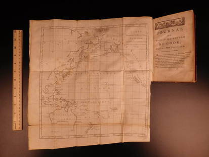
Sold2022Extraordinary Book of Engravings from Captain Cook's Voyages, c. 1784First Edition, c. 1784. 60 copperplate engravings drawn by John Webber (1751-1793) on chain-laid paper. Depicting images from the three voyages of Captain Cook. Contains a foldout map at the rear. PrSee Sold Price
Sold2021Antique Map of Captain James Cook's Voyages to theAntique map of Captain James Cook's voyages to the Pacific region. Captain Cook made numerous discoveries in the Pacific region during the late 1700's . Artists and mapmakers aboard the ship, includinSee Sold Price
Sold20241783 Captain James Cook Third Pacific Voyage Illustrated MAP Australia Rickman1783 Captain James Cook Third Pacific Voyage Illustrated MAP Australia Rickman “Remember, the greater the opportunity, the fewer are those who see it.” – James Cook James Cook was an 18th-ceSee Sold Price
Sold2022MAP "THE WORLD ON MERCATOR'S PROJECTION SHEWING THE VOYAGE OF CAPTAIN COOK ROUND THE WORLD." CircaMAP "THE WORLD ON MERCATOR'S PROJECTION SHEWING THE VOYAGE OF CAPTAIN COOK ROUND THE WORLD."Circa 1800Published by The London Printing and Publishing Company. Engraved for R. Montgomery MartSee Sold Price
Sold2017A Blondeau: Mappe-Monde ou Carte Generale de la TerreMap: Mappe-Monde ou Carte Generale de la Terre, 1817 Maker: A Blondeau Date: 1817, Paris Description: An uncommon two hemisphere world map. The shown US border far exceeds into Canada north of MinnesoSee Sold Price
Sold2023James Cook Antiquated MapAntiquated framed and glazed map / 'agenera chart' depicting the voyages and discoveries of Captain James Cook height 28 in. x width 42 in. x depth 1.5 in. We happily provide seamless shippiSee Sold Price
Sold2021Three Framed PrintsThree Framed Prints, 18th C. and later, comprising a "Mappe Monde" global map, an engraving of kittens by Caroline Lambert, and a N.C. Wyeth Civil War print Mappe Monde: 8-1/4"h x 9-3/4"w Kittens: 9-3See Sold Price
Sold20191783 Captain James Cook Third Pacific Voyage Illustrate1783 Captain James Cook Third Pacific Voyage Illustrated MAP Australia Rickman “Remember, the greater the opportunity, the fewer are those who see it.” – James Cook James Cook was an 18th-centurSee Sold Price
Sold2017Desnos/de la Tour: Antique Map of World in HemispheresTitle/Content of Map: 'Mappe-Monde, dressée pour l'etude de la Géographie, rélativement aux auteurs les plus modernes. Revûë, corrigée et augmentée d'apres les Nouvelles Observations AstronomiqSee Sold Price
Sold20181780 Captain Cook VOYAGES Explorers Easter Island1780 Captain Cook VOYAGES Explorers Easter Island Pacific Ocean Hebrides Tahiti The best book of its kind! A rare book La Harpe’s ‘General History of Voyages’! This extensive work was begun by LSee Sold Price
Featured5 days LeftJasper521699 Moll World Map with Cowley's Voyages -- Nouvelle Carte du Monde Suivant l'idee de Mercator ou$240
5 days LeftJasper521723 Dampier Map of Voyages to Brazil, Australia and Eat Indies -- Voyage du Cap. Dampier a la N.$280
6 days LeftJasper52Extremité Meridionale de l'Amérique Tierra del Fuego Magellan Str BONNE 1788 map$35
Jun 02Schilb Antiquarian Rare Books1880 Captain James Cook Voyages Hawaii Pacific Australia Kippis South Sea Navy$50(3 bids)
Jun 23Schilb Antiquarian Rare Books1786 Voyages James Cook New Zealand Tahiti Palestine Palmyra Temple SYRIA 4v$2(2 bids)
5 days LeftJasper521794 de la Rochette Map of the English Channel and Bay of Biscay -- A Chart of the British Channel$240
6 days LeftForum AuctionsMeunier (Charles, binder).- Haraucourt (Edmond) L'Effort: La Madone. L'Antéchrist. L'Immortalité.£2,600
5 days LeftJasper521719 Chatelain Map of the Adriatic and Venice Republic -- Carte de Geographie des Differents Etats$190
Jun 07Freeman's | HindmanCOOK, James, Captain. -- [SECOND VOYAGE]. A Voyage towards the South Pole, and Round the World...$1,500
5 days LeftJasper521792 ANCIENT HISTORY of INDIA antique ILLUSTRATED w/ MAPS 18th CENTURY in FRENCH$170
Jun 08Early American History AuctionsFrench and Indian War 1758 CT. Fiscal Document Signed Joseph Talcott Treasurer to Repay John Ledyard$1,400
1818 AuctioneersCurio. Leon, Henri M. - Sheikh Haroun Abdullah: A Turkish Poet, and his Poetry. Being the Life of£22(2 bids)
1818 AuctioneersAntiquarian. Theology. A small selection, includes: Sales, B. St. Francis - The Spiritual Directer£34(2 bids)


![COOK, James, Captain. -- [SECOND VOYAGE]. A Voyage towards the South Pole, and Round the World... (1 of 2)](https://p1.liveauctioneers.com/197/329395/177650491_1_x.jpg?height=282&quality=70&version=1715364962)


