Sold2024Large Original 1958 Bird's Eye View Map of ParisLarge Original 1958 Bird's Eye View Map of ParisLarge Original 1958 Bird's Eye View Map of Paris in vibrant green, red, and black tones, states "Printed in France - Published By and For the FrencSee Sold Price
Sold2024Joseph Pinchon (manner), hand-painted Paris mapJoseph Pinchon (manner), hand-painted Paris map, Manner of Joseph Porphyre Pinchon (French, 1871-1953), Bird's eye view of the 2nd and 8th Arrondissements, watercolor on paper, no signature detected,See Sold Price
Sold2020G. Braun & F. Hogenberg: MAP OF PARIS, 1575Bird’s-eye view of the city of Paris and surrounding countryside; Title in cartouche: "LUTETIA vulgari nomine Paris, urbs Galliae maxima" From Braun and Hogenberg’s atlas “Civitates Orbis TerrarSee Sold Price
Sold2021RARE BELLE EPOQUE TOURIST'S POCKET MAP OF PARISRare and highly collectible color-engraved pocket map of Paris's environs from a partial birds-eye view, with travel routes and vignettes depicting popular monuments and attractions. On the reverse, aSee Sold Price
Sold2022WW2 'WESTERN FRONT' in 1940. Bird's eye view before invasion of France 1940 mapTITLE/CONTENT OF MAP: 'Daily Mail Air-View Map of the Western Front' DATE PRINTED: 1940 IMAGE SIZE: Approx 97.0 x 74.0cm, 38 x 29 inches (Large) TYPE: Vintage colour map; Scale 10 miles: 1 inch CONDITSee Sold Price
Sold2024Interesting Pastel w Ferris Wheel, Ca. 1900-1920Signed R. Nanners, pastel on paper depicting a bird's eye view of a large industrial city, with a Ferris Wheel set against a dusk horizon. Possibly Chicago, possibly Paris, unknown location. 7.5" x 10See Sold Price
Sold2022Roofs of Paris oil on canvas signed "Cordet" at lower right, mid-20th C., depicts a bird's eye viewRoofs of Paris oil on canvas signed "Cordet" at lower right, mid-20th C., depicts a bird's eye view of roof-tops, large blocks of colors applied with palette knife, scattered areas of outlining, in moSee Sold Price
Sold2020Pan Pacific Exposition Birds-Eye View MapReproduction produced 1968 by First Savings and Loan Association from the original lithograph in the collection of the Society of California Pioneers. Color illustrated birds-eye view: "The ExpositionSee Sold Price
Sold2017Mallet: Antique Miniature Santo Domingo Plan, 1683Map: Plan de la Ville de San-Domingo Cartographer: Mallet Place & Date: Paris / 1683 Size: 4 1/4" x 6" Condition: b&w; light overall age toning A charming bird's eye view of the old walled city of SanSee Sold Price
Sold2019Birds-Eye View of ViennaTitle: Birds-Eye View of Vienna Publication Date: c1949 Cartographer: FREYTAG-BERNDT u. ARTARIA Publisher: AMERICAN RED CROSS Size: 18 X 25.5 Interesting large scale map of environs of Vienna publisheSee Sold Price
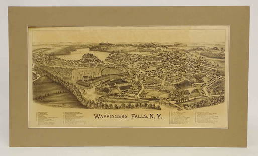
Sold2022Wappingers Falls New York Large ViewWappingers Falls, N.Y. Large Panorama Bird's-eye Map. L.R. Burleigh, Troy, New York, c. 1889. Antique print. 15" x 29".See Sold Price
Sold2023Bird's Eye View Map of Middletown, ConnecticutBird's Eye View Map of Middletown, Connecticut, originally published in 1877 by O.H. Bailey & Company, for the Library of Congress, Washington, D.C. revised in 1880 with additional rare border, includSee Sold Price
Sold20221890 Kessler Brewery/American Publishing Birds Eye View Map of Helena Montana -- Perspective Map ofTitle: 1890 Kessler Brewery/American Publishing Birds Eye View Map of Helena Montana -- Perspective Map of the City of Helena, Mont. Capital of State, County Seat of Lewis & Clarke Co. 1890 CartographSee Sold Price
Sold2017Currier & Ives: San Francisco Birds Eye View Map, 1878Map: The City of San Francisco Birds Eye View Looking from the Bay South-West Cartographer: Currier & Ives Date: 1878 Size: 11.4 x 17.75 inches This is a rare view of San Francisco of the late 1800s lSee Sold Price
Sold2023Bird's-Eye View Map of the City of Chicago (1874)Bird's-eye view map of the city of Chicago, Illinois sketched and drawn by Parsons & Atwater, published by Currier & Ives, dated 1874; unframed. Provenance: Phyllis Lucas Gallery, NYC. [Sheet: 23 1/4"See Sold Price
Sold2023Franklin Square Lithographic Company - Bird's Eye View of the Great Suspension Bridge, NYLot 38 Franklin Square Lithographic Company American ManufacturerBird's Eye View of the Great Suspension Bridge, NY lithograph large bird's-eye view of the Brooklyn Bridge the ”Great SuspensionSee Sold Price
Sold2022BISHOP, Roy. Seattle. Bellevue: Bayside Publishing, 1976. C...BISHOP, Roy. Seattle. Bellevue: Bayside Publishing, 1976. Cartoonish pictorial bird’s-eye view map poster of Seattle. While the artist labels the city’s roads, bridges, and waterways, andSee Sold Price
Sold2022Disneyland Souvenir Map. 1972. Walt Disney Productions, 197...Disneyland Souvenir Map. 1972. Walt Disney Productions, 1972. Bird’s-eye view map of the park, with an inset vignette advertising Disneyland’s Bear Country attraction in the lower left. 30See Sold Price
Sold2024Theodore R. David (American 1840-1894) For Harper's Weekly 1872Theodore R. David (American 1840-1894) For Harper's Weekly 1872 "Birds Eye View Map of Philadelphia" colored and engraved map, published June 15, 1872 21" x 31" Condition: having yellowing to paper anSee Sold Price
Sold20201587 Birds Eye View of Ghent -- [Untitled] GentTitle/Content of Map: 1587 Birds Eye View of Ghent -- [Untitled] Gent Date: 1587 c. Cartographer: Anonymous Size: 8.3 x 10.6 in. A very nice and detailed birds' eye view map of the market city of GhenSee Sold Price
Sold2024Map Of Sarajevo 1992-1995 LithoA litho map of Sarajevo during the years of the siege of Sarajevo. Reading 1991-1995 Colored Birds Eye view map of the city depicting military artillery and tanks outlining the exterior of the map. FrSee Sold Price
Sold2022Lot 2, Vintage Scratch Map & Boston Block Print1 vintage scratch map of the world. Approximately 23 x 32 inches. 1 The town of Boston in New England by John Bonner, 1722. Depicting a birds eye view map of the city of Boston in 1722. ApproximatelySee Sold Price
Sold2023RARE LARGE COLORED BIRD'S EYE VIEW OF THE CITY OFBANGOR. Circa 1875, Penobscot County, Maine. Published by J.J. Stoner, Madison, Wis. Drawn by Augustus Koch. Engraved by Chas. Shober & Co. Prop's Chicago Lith. Co. This large black and white lithograSee Sold Price
Sold2022SHELTON, Hal (1916-2004). Sierra Blanca / Ruidoso, New Mexi...SHELTON, Hal (1916-2004). Sierra Blanca / Ruidoso, New Mexico. Circa 1960s. Poster featuring Shelton’s detailed bird’s-eye view ski map of the Sierra Blanca Peak in Lincoln National ForestSee Sold Price
5 days LeftSwann Auction Galleries(NEW YORK CITY.) H. Walter; after John Bachmann. Vue General de New-York.$2,200
5 days LeftSwann Auction Galleries(NEW YORK CITY.) Sigismund Himely, engraver; after Wilhelm Heine, Julius Hermann Kummer, and Karl$3,000
5 days LeftSwann Auction Galleries(NEW YORK CITY.) Leon Auguste Asselineau; after John Bachmann. Vue Generale de New-York Prise a vol$2,200
5 days LeftSwann Auction Galleries(NEW JERSEY.) Oakley Hoopes Bailey. Atlantic Highlands, New Jersey.$750
5 days LeftSwann Auction Galleries(CIVIL WAR.) John Bachmann. Panorama of the Seat of War - Bird's Eye View of Virginia, Maryland,$600
5 days LeftSwann Auction Galleries(KANSAS CITY.) Lanward Specialty Publishing Co. Wonderful Growth of the Metropolis of the Great$900
5 days LeftSwann Auction Galleries(NEW YORK CITY.) Currier & Ives; with Charles Parsons and Lyman Atwater. The Port of New York,$3,800
5 days LeftSwann Auction Galleries(NEW JERSEY.) National View Co. Port au Peck. Near Long Branch, Monmouth Co., New Jersey.$500
4 days LeftJasper52Stratford-upon-Avon & William Shakespeare's life. Kerry Lee pictorial map c1965$440
4 days LeftJasper52Westmoria Comitatus; Anglice Westmorland. Westmoreland county map by Blaeu 1645$280
4 days LeftJasper52Penbrochia Comitatus &... Caermaridunum. Carmarthen/Pembrokeshire BLAEU 1645 map$360


![1587 Birds Eye View of Ghent -- [Untitled] Gent: Title/Content of Map: 1587 Birds Eye View of Ghent -- [Untitled] Gent Date: 1587 c. Cartographer: Anonymous Size: 8.3 x 10.6 in. A very nice and detailed birds' eye view map of the market city of Ghen](https://p1.liveauctioneers.com/5584/165933/83741827_1_x.jpg?height=310&quality=70&version=1586907661)


