Sold2021Lochhead (Pub) 1811 Rare Map. Mexico, West Indies, USA"New Mexico New Spain with the West Indies" Showing Unmapped Southern States around the Guld of Mexico, New Mexico, Mexico, New Spain, Cuba, Haiti and The West Indies. Copper Engraved Map Published 18See Sold Price
Sold2021Lochhead (Pub) 1811 Rare Map. AfricaCopper Engraved Map Published 1811 by William Lochhead, Berwick for "Modern Geography: And a Compendious General Gazetteer" Rare. Folds as issued. Paper Size: 12 x 10 inch (30 x 26cm) Very minor toninSee Sold Price
Sold2021Lochhead (Pub) 1811 Rare Map. World HemisphereCopper Engraved Map Published 1811 by William Lochhead, Berwick for "Modern Geography: And a Compendious General Gazetteer" Rare. Folds as issued. Paper Size: 17 x 11 inch (43 x 28cm) Some creasing. VSee Sold Price
Sold2021Lochhead (Pub) 1811 Rare Map. Russia in Europe"The Southern Part of Russia in Europe with Russian and Little Tartary" Copper Engraved Map Published 1811 by William Lochhead, Berwick for "Modern Geography: And a Compendious General Gazetteer" RareSee Sold Price
Sold2021Lochhead (Pub) 1811 Rare Map. IrelandCopper Engraved Map Published 1811 by William Lochhead, Berwick for "Modern Geography: And a Compendious General Gazetteer" Rare. Folds as issued. Paper Size: 10 x 8.5 inch (26 x 22cm) Very minor toniSee Sold Price
Sold2021Lochhead (Pub) 1811 Rare Map. AsiaCopper Engraved Map Published 1811 by William Lochhead, Berwick for "Modern Geography: And a Compendious General Gazetteer" Rare. Folds as issued. Paper Size: 12 x 10 inch (30 x 26cm) Very minor toninSee Sold Price
Sold2021Lochhead (Pub) 1811 Rare Map. EgyptCopper Engraved Map Published 1811 by William Lochhead, Berwick for "Modern Geography: And a Compendious General Gazetteer" Rare. Folds as issued. Paper Size: 11 x 8.5 inch (28 x 22cm) Good ConditionSee Sold Price
Sold2021Lochhead (Pub) 1811 Rare Map. South America"The Southern Part of South America" Copper Engraved Map Published 1811 by William Lochhead, Berwick for "Modern Geography: And a Compendious General Gazetteer" Rare. Folds as issued. Paper Size: 10.5See Sold Price
Sold2021Lochhead (Pub) 1811 Rare Map. FranceCopper Engraved Map Published 1811 by William Lochhead, Berwick for "Modern Geography: And a Compendious General Gazetteer" Rare. Folds as issued. Paper Size: 11 x 10 inch (28 x 26cm) Good ConditionSee Sold Price
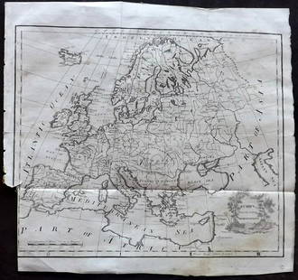
Sold2021Lochhead (Pub) 1811 Rare Map. EuropeCopper Engraved Map Published 1811 by William Lochhead, Berwick for "Modern Geography: And a Compendious General Gazetteer" Rare. Folds as issued. Paper Size: 12 x 10.5 inch (30 x 27cm) Some tone spotSee Sold Price
Sold2021Lochhead (Pub) 1811 Rare Map. ItalyCopper Engraved Map Published 1811 by William Lochhead, Berwick for "Modern Geography: And a Compendious General Gazetteer" Rare. Folds as issued. Paper Size: 10.5 x 10 inch (27 x 26cm) Very minor tonSee Sold Price
Sold2021Lochhead (Pub) 1811 Rare Map. England and WalesCopper Engraved Map Published 1811 by William Lochhead, Berwick for "Modern Geography: And a Compendious General Gazetteer" Rare. Folds as issued. Paper Size: 10.5 x 9.5 inch (27 x 24cm) Very minor toSee Sold Price
Sold2021Lochhead (Pub) 1811 Rare Map. Netherlands Holland"The Severn United Provinces with the Dutch and Austrian Netherlands" Copper Engraved Map Published 1811 by William Lochhead, Berwick for "Modern Geography: And a Compendious General Gazetteer" Rare.See Sold Price
Sold2021Russell, William 1778 Rare Map of The West Indies"The West Indies and Gulf of Mexico" Copper Engraved Map Published 1778, London for "The History of America, From Its Discovery by Columbus to the Conclusion of the Late War" by William Russell. EngraSee Sold Price
Sold2024Scarce 1st ed./1st printing of Mitchell map of Mexico/W. IndiesAuthentic first edition/first printing of Samuel A. Mitchell Jr’s Map of Mexico, Central America and the West Indies, with plate number just above title, indicating the rare first state of this map.See Sold Price
Sold2023Thomson, John (Pub) 1825 Map. West Indies CaribbeanCopper Engraved Map Published 1825 by John Thomson, Edinburgh for "The Edinburgh School Atlas" by N. R. Hewitt. Maps Engraved by Hewitt. Original Outline Hand Colour. Rare. Paper Size: 10.5 x 8 inch (See Sold Price
Sold2020Brockhaus (Pub) 1890's Mixed Lot of 9 MapsIncl West Indies, America Continent, USA, Alexander The Great, Asia, and Middle East. Lithograph Maps 1892-98 by F. A. Brockhaus, Leipzig for "Brockhaus' Konversations-Lexikon" by Various. Centre foldSee Sold Price
Sold2021[WALL MAP]. Colton's map of the U.S.A . NY: 1853J.H. COLTON (publisher) [WALL MAP]. Colton's map of the United States of America, the British provinces, Mexico and the West Indies. [WALL MAP]. Colton's map of the United States of America, the BritiSee Sold Price
Sold2024Carey, pub. 1796 - A Chart of the West IndiesThis fine map engraving is from one of the ealiest American atlases published in the states: Mathew Carey's General Atlas. The work was published in Philadelphia by Carey in 1796. It was an importantSee Sold Price
Sold2024Russell & Allen (Pub) 1812 Map. West Indies CaribbeanFolio Copper Engraved Map Published 1812 by Russell and Allen, Manchester for "A New And Commercial System Of Geography" Paper Size: 15.5 x 9 inch (39 x 23cm) Very minor margin toning. Good ConditionSee Sold Price
Sold2022Kearsley (Pub) 1802 Map. West Indies CaribbeanCopper Engraved Map Published 1802 by George Kearsley, London for "The English Encyclopaedia..." Folds as issued. Paper Size: 16.5 x 10.5 inch (41 x 27cm) Minor wrinkles. Good ConditionSee Sold Price
Sold2018Bellin: Antique Map Gulf of Mexico & West Indies, 1754Title/Content of Map: Carte du Golphe de Mexique et des Isles de l'Amerique Cartographer: Jacques Bellin Place & Date: Paris / 1754/1760 Size: 14 3/4" x 10 3/4" Condition: b&w; old folds as published;See Sold Price
Sold2017Kitchin: Antique Map Gulf of Mexico / West Indies, 1778Map: Kaart van de Golf van Mexico, de Eilanden en de Aangrenzende Landschappen Cartographer: Thomas Kitchin Place & Date: Amsterdam / 1778 Size: 19 1/8" x 12 1/4" Condition: b&w; a beautifully preservSee Sold Price
Sold20201754 Bellin Map Gulf of Mexico West IndiesMap of Jacques Bellin circa 1754 entitled "Cartes Du Golphe Du Mexique Et Des Isles De L'Amerique", printed at Paris. Very Good, folds and light tatter, measures 16.5 x 13.5". Reserve: $70.00 ShippingSee Sold Price
Jun 23Schilb Antiquarian Rare Books1877 Geology Geography Surveys 1ed Nevada Wyoming Utah George Wheeler US West 2v$1
Jun 23Schilb Antiquarian Rare Books1848 Emory Military Reconnaissance 1ed California MAP Indians Texas New Mexico$2(2 bids)
5 days LeftTrillium Antique Prints & Rare BooksKarl Bodmer - "Dog Dance"; P?hriska-R?hpa. Moennitarri Warrior in the Costume of the Dog Danse$350(2 bids)
Jun 23Schilb Antiquarian Rare BooksUS War w/ SPAIN 1898 1ed Puerto Rico CUBA Philippines MAPS Russell Illustrated$76(4 bids)
6 days LeftSchilb Antiquarian Rare Books1844 Sparks American Biography Zebulun PIKE US Military Voyages 5v USA$1(1 bid)
3 days LeftCedarburg Auction & Appraisals LLCAntique Small Bent Wood Pantry Box and 1846 Receipt$50(2 bids)


![[WALL MAP]. Colton's map of the U.S.A . NY: 1853: J.H. COLTON (publisher) [WALL MAP]. Colton's map of the United States of America, the British provinces, Mexico and the West Indies. [WALL MAP]. Colton's map of the United States of America, the Briti](https://p1.liveauctioneers.com/7142/218924/116475153_1_x.jpg?height=310&quality=70&version=1636469267)


