Sold2022Cortambert french Africa map 1864 engraving hand coloredEugene Cortambert (french, 1805-1881): french Africa map, copper hand colored engraving, from Geographie Universelle de Malte-Brun published in 1864 in Paris by Boulanger & Legrand.24" X 19”.DimSee Sold Price
Sold2024Tardie Map of Italy, 1874Tardie Map of Italy Provenance: 'Atlas Universel de Geographie ancienne et moderne', by A. Tardieu and A. Vuillemin for 'L'Intelligence de la Geographie Universelle de Malte-Brun LaVallee, Paris, 1874See Sold Price
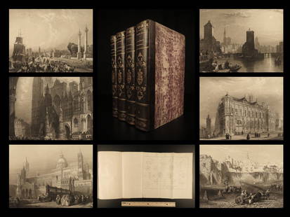
Sold20191843 Geography WORLD VIEWS Atlas Illustrated Jerusalem1843 Geography WORLD VIEWS Atlas Illustrated Jerusalem Israel India 6v Malte-Brun Conrad Malte-Brun was a French geographer and cartographer known for his impressive journal-like atlases and geographySee Sold Price
Sold2017John Grigg: Map of Western States & Territories, 1830Map: Western States & Territories Maker: John Grigg, Malte-brun, Conrad/ J. H. Young Date: 1830 Size: Quarto, 9.75 inches high x 8 inches wide From Malte-Brun's "A new General atlas, exhibiting the fiSee Sold Price
Sold2017John Grigg: Map of North America, 1830Map: North America Maker: John Grigg, Malte-brun, Conrad/ J. H. Young Date: 1830 Size: Quarto, 9.8 inches high x 8 inches wide From Malte-Brun's "A new General atlas, exhibiting the five great divisioSee Sold Price
Sold20181850 MAPS Atlas Geography Illustrated Jerusalem CHINA1850 MAPS Atlas Geography Illustrated Jerusalem CHINA 8v Malte-Brun Conrad Malte-Brun was a French geographer and cartographer known for his impressive journal-like atlases and geography books. UnfortSee Sold Price
Sold2017Malte-Brun: Map of Asia, 1830Map: Asia Maker: John Grigg, Malte-brun, Conrad/j. H. Young, Sc. Publication Date: 1830 Publisher: John Grigg Size: Quarto – 8.00 H x 9.75 W Inches From Malte-Brun's "A new General atlas, exhibitingSee Sold Price
Sold2018Malte-Brun: Antique Map of Central Oceanica, 1830Title/Content of Map: Central Oceanica Date Printed: 1830 Cartographer: MALTE-BRUN, CONRAD/J. H. YOUNG, sc. Size (inches): 7.5x7.5 From Malte-Brun's "A new General atlas, exhibiting the five great divSee Sold Price
Sold2024Spain & PortugalPublication Date: 1828 Title: Spain & Portugal Cartographer: MALTE-BRUN, CONRAD/J. H. YOUNG, sc. Publisher: JOHN GRIGG Height: 8.1 Width: 9.8 From Malte-Brun's "A new General atlas, exhibiting the fivSee Sold Price
Sold2024FrancePublication Date: 1828 Title: France Cartographer: MALTE-BRUN, CONRAD/J. H. YOUNG, sc. Publisher: JOHN GRIGG Height: 8.25 Width: 9.75 From Malte-Brun's "A new General atlas, exhibiting the five greatSee Sold Price
Sold2018Map of Mongol Empire Coloured by Hand 1842 Malte-BrunMap of Mongol Empire Coloured by Hand 1842 Malte-Brun Etching On Steel 1842 Malte-Brun Conrad (1775-1826) etching on steel Leaf Dimension: 32x25,5 cm (12.6x10.04 inches)Engraving Dimension: 26x20 cm (See Sold Price
Sold2020Mappemonde en Deux Hemispheres Conrad Malte-Brun 1846Antique Map 'Mappemonde en Deux Hemispheres' [World Map in Two Hemispheres] by Conrad Malte-Brun (1775 - 1826) | DATE: c. 1846 | SIZE: Map with borders: Approx. 16" H x 22" W (40.64 x 55.88cm); imageSee Sold Price
Sold20221841 BEAUTIFUL Geography by Malte-Brun Illustrated1841 BEAUTIFUL Geography by Malte-Brun Illustrated Jerusalem Edinburg Ruins 4v Conrad Malte-Brun was a French geographer and cartographer known for his impressive journal-like atlases and geography boSee Sold Price
Sold20173 Vol Universal Geography/Description of the World 1824Volumes 1-3 Book Title: Universal Geography or a Description of All Parts of the World Author: M. Malte-Brun Publishing: Boston, Wells and Lilly, 1824 Conrad Malte-Brun (1775-1826) born Malthe ConradSee Sold Price
Sold2017Malte-Brun: Antique Map of Portugal & Spain, 1812Title/Content of Map: Portugal with parts of Western Spain Date Printed: 1812 Cartographer: Malte-Brun Material/Medium: Paper Size: 10" x 13 1/2" Published in Paris Conrad Malte-Brun (1775 - 1826), boSee Sold Price
Sold2017Thierry Malte-Brun: Antique Map of England, 1834Title: Map of Angleterre by Thierry Malte-Brun Date: c 1834 Medium: Hand Colored Lithograph Dimensions (in.): 10.75 x 16.5 Conrad Malte-Brun (1775 - 1826), born Malthe Conrad Bruun, and sometimes refeSee Sold Price
Sold2017Malte-Brun: Antique Map of the World per Herodotus 1812Title/Content of Map: 1812 Malte-Brun Map of the Known World per Herodotus -- Geographie d'Herodote Date Printed: 1812, Paris Cartographer: M Malte-Brun Size: 8.7 X 11.7 in. An excellent and very inteSee Sold Price
Sold2015[Napoleon, St. Helena] Malte-Brun - Brooke, 1815, 2 v.SCARCE EDITIONS OF TWO BOOKS ABOUT THE LIFE OF NAPOLEON AT ST. HELENA, AND A DESCRIPTION OF THE HISTORY AND LANDSCAPE OF THE ISLAND OF ST. HELENA [[1.]: Anonimo. Carnet d'un voyageur, ou Recueil de noSee Sold Price
Sold2024BIOGRAPHIE UNIVERSELLE OU DICTIONNAIRE DES HOMMES QUI SE SONT FAIT UN NOM, 8 VOLUMES - 1851Paris. 1851. J. B. Pelagaud Et Cie Imprimeurs-Libr. Complete in 8 volumes. All volumes in Very Good condition. Written entirely in French. All bound in half brown leather hard cover with blue marbledSee Sold Price
Sold2017Malte-Brun: Antique Map of Northern Africa, 1812Map: 1812 Malte-Brun Map of Northern Africa -- Afrique Ancienne Cartographer: M Malte-Brun Year / Place: 1812, Paris Map Dimensions: 8.7 X 12.7 in. Condition: Very Good - Excellent. Color outlined onSee Sold Price
Sold20171812 Malte-Brun Map of Siberian and Alaskan RussiaTitle: 1812 Malte-Brun Map of Siberian and Alaskan Russia -- Siberie avec lAmerique RussePartie Meridionale de la Russie d'Europe Cartographer: M Malte-Brun Origin/Date: 1812, Paris Size: 8.7 inches XSee Sold Price
Sold2017Malte-Brun: Map of Europe, Barbarian Invasions, 1811Map: 1811 Malte-Brun Map of Europe during the Barbarian Invasions -- L'Europe apres l'invasion des Barbares Cartographer: M Malte-Brun Year / Place: 1811, Paris Map Dimensions: 8.7 X 11.7 An outstandiSee Sold Price
Sold2017Malte-Brun: Antique Map of Europe in 1829Title/Content of Map: 1829 Malte-Brun Map of Europe in 1829 -- Europe en 1829 Date Printed: 1829, Paris Cartographer: M Malte-Brun Size: 8.7 X 11.7 in. An attractive map of Europe showing its politicaSee Sold Price
Sold20171834 Malte-Brun Map of Ireland1834 Malte-Brun Map of Ireland -- Ireland. M. Malte-Brun / S. Walker. 1834, Boston. 9.3 x 7.5 in. An attractive and highly detailed map with topographical and settlement details. From the American ediSee Sold Price
3 days LeftWorthington GalleriesAntique Hand-colored Hemisphere Map Mappemonde Revue par E. Cortambert 1864$25
160 Lots AwayJasper52Afrique Ancienne. Ancient North Africa. MALTE-BRUN c1871 old antique map chart$20
Will Sullivan Auction Co.Circa 1980 Winchester Xpert Model 96 (26.5" M/IC), 20 Ga., O/U, SN - K249864$950(19 bids)
2 days LeftFreeman's | Hindman[MAP]. ORTELIUS, Abraham. Americae Sive Novi Orbis, Nova Descriptio. 1573.$1,000(1 bid)
7 days LeftLeland LittleCharles Joshua Chaplin (French, 1825-1891), Madelaine ou L'extase$350(6 bids)
3 days LeftRoland NYVintage Hermes Paris Silk Scarf "Pani la Shar Pawnee ou l'indien" with box$200(4 bids)
4 days LeftPacific AuctionsANTIQUE CHAMBRE CLAIRE UNIVERSELLE MODELE DEPOSE CAMERA LUCIDA COMPLETE WITH ORIGINAL BOX$50(3 bids)
13 hrs LeftFreeman's | HindmanCONRAD, Joseph (1857-1924). A group of 12 FIRST EDITIONS in dust jackets, comprising:$150(1 bid)
13 hrs LeftFreeman's | HindmanCONRAD, Joseph (1857-1924). Tales of Unrest. London: T. Fisher Unwin, 1898.$300(1 bid)
2 days LeftFreeman's | Hindman[MAP]. ORTELIUS, Abraham. Presbiteri Iohannis, sive, Abissinorum Imperii Descriptio. 1592.$200
2 days LeftFreeman's | HindmanBELLIN, Jacques-Nicolas. Carte Reduite de L'Ocean Oriental ou Mer Des Indies. Paris, 1757. Second$150
2 days LeftFreeman's | Hindman[ASTRONOMY]. MOXON, Joseph. A Tutor to Astronomie and Geographie... 1659.$200
BonhamsEGYPT - ANTIQUITIES [Description de l'Égypte, ou recueil des observations et des recherches...£400
6 days LeftBonhamsSAUTERELLE ARTICULÉE EN CUIVRE, JIZAI OKIMONO Japon, période Meiji (1868-1912) ou Tais...€1,200(1 bid)
13 hrs LeftFreeman's | HindmanCONRAD, Joseph (1857-1924). Notes on Life and Letters. London & Toronto: J.M. Dent & Sons, 1921.$300
6 days LeftBonhamsGRILLON ARTICULÉ EN CUIVRE, JIZAI OKIMONO Japon, période Meiji (1868-1912) ou Taisho (...€1,600(1 bid)


![Mappemonde en Deux Hemispheres Conrad Malte-Brun 1846: Antique Map 'Mappemonde en Deux Hemispheres' [World Map in Two Hemispheres] by Conrad Malte-Brun (1775 - 1826) | DATE: c. 1846 | SIZE: Map with borders: Approx. 16" H x 22" W (40.64 x 55.88cm); image](https://p1.liveauctioneers.com/6084/186772/93903861_1_x.jpg?height=310&quality=70&version=1606446047)


![[Napoleon, St. Helena] Malte-Brun - Brooke, 1815, 2 v.: SCARCE EDITIONS OF TWO BOOKS ABOUT THE LIFE OF NAPOLEON AT ST. HELENA, AND A DESCRIPTION OF THE HISTORY AND LANDSCAPE OF THE ISLAND OF ST. HELENA [[1.]: Anonimo. Carnet d'un voyageur, ou Recueil de no](https://p1.liveauctioneers.com/2198/81135/42158655_1_x.jpg?height=310&quality=70&version=1447166404)


![[MAP]. ORTELIUS, Abraham. Americae Sive Novi Orbis, Nova Descriptio. 1573. (1 of 2)](https://p1.liveauctioneers.com/197/329395/177650534_1_x.jpg?height=282&quality=70&version=1715364962)


![[MAP]. ORTELIUS, Abraham. Presbiteri Iohannis, sive, Abissinorum Imperii Descriptio. 1592. (1 of 2)](https://p1.liveauctioneers.com/197/329395/177650536_1_x.jpg?height=282&quality=70&version=1715364962)

![[ASTRONOMY]. MOXON, Joseph. A Tutor to Astronomie and Geographie... 1659. (1 of 1)](https://p1.liveauctioneers.com/197/329395/177650311_1_x.jpg?height=282&quality=70&version=1715364962)


