Sold2016Map of Nevada, 1895Original engraving from Atlas of the World by Rand McNally, 1895. Map includes counties, geographical landmarks, streets and population data. Dimensions: 21 1/4" x 14" No Reserve Buyer pays shipping.See Sold Price
Sold2023LINDGREN, Hjalmer “Jolly” (1895–1952). A Hysterical Map of ...LINDGREN, Hjalmer “Jolly” (1895–1952). A Hysterical Map of Lake Tahoe and Woolly Nevada with Its Open Places. 1947. Spokane, WA: Lindgren Bros. Color pictorial map of the Lake TahoeSee Sold Price
Sold20201895 Map of Zanzibar Island and adjacent areasTitle/Content of Map: 1895 Map of Zanzibar Island and adjacent areas Date Printed: 1895 Material/Medium: Lithograph Size: 15.5CM*23.5CM Provenance: Leipzig Academy of Literature Reserve: $120.00 ShippSee Sold Price
Sold20181895 Rand McNally Map of Texas and Indian TerritoryTitle/Content of Map: 1895 Rand McNally Map of Texas and Indian Territory/Oklahoma -- Texas; Oklahoma and Indian Territory Date Printed: 1895 Chicago Cartographer: Rand McNally Size: 9.2 x 12.5 in. ThSee Sold Price
Sold20201895 Cram Comparison of Tall Buildings Globally --Title/Content of Map: 1895 Cram Comparison of Tall Buildings Globally -- Diagram of the Principal High Buildings of the World Date: 1895, Chicago Cartographer: G Cram Size: 13.2 x 10.5 in. This intereSee Sold Price
Sold2017Rand McNally: Antique Map of Texas & Indian TerritoryMap: 1895 Rand McNally Map of Texas and Indian Territory/Oklahoma -- Texas; Oklahoma and Indian Territory Cartographer: Rand McNally Year / Place: 1895 Chicago Map Dimensions: 9.2 x 12.5 in. ConditionSee Sold Price
Sold2017Rand McNally: Antique Map of Texas & Indian TerritoryTitle/Content of Map: 1895 Rand McNally Map of Texas and Indian Territory/Oklahoma -- Texas; Oklahoma and Indian Territory Date Printed: 1895 Chicago Cartographer: Rand McNally Size: 9.2 x 12.5 in. CoSee Sold Price
Sold20181895 Johnston Map of Ireland -- IrelandReserve Reduced! Title/Content of Map: 1895 Johnston Map of Ireland -- Ireland Date: 1895, London, Edinburgh Cartographer: W& A K Johnston Size: 12.4 x 9.5 in. A very detailed map of Ireland from theSee Sold Price
Sold2018Rand McNally: Antique Maps of New Orleans/LouisianaTitle/Content of Map: 1895 Rand McNally Maps of New Orleans and Louisiana -- New Orleans [verso] Louisiana Date Printed: 1895, Chicago Cartographer: Rand McNally Size: 11.5 x 9 in. Very nice and highlSee Sold Price
Sold2023Antique Hyde and Co Brooklyn NY Wall Map Scroll 1895Hyde and Co Brooklyn NY Map 1895. Map of the city of Brooklyn, Kings County, with wooden roll bars on top and bottom. Published by Hyde and Co of Brooklyn NY.Dimensions are 37 in h x 27 in w. ConditioSee Sold Price
Sold2017Maps of St. Petersburg & Edinburgh, 1895Map: 1895 Maps of St. Petersburg and Edinburgh -- St. Petersburg (Russia) [verso] Edinburgh Scotland Year / Place: 1895 Map Dimensions: 9.3 x 12 in. Condition: Very good. Nicely colored. Age toning, mSee Sold Price
Sold20191895 Rand McNally Map of California and [verso] SanTitle/Content of Map: 1895 Rand McNally Map of California and [verso] San Francisco Date: 1895, Chicago Cartographer: Rand McNally Size: 11.4 x 9.4 in. An excellent map of California and on reverse, SSee Sold Price
Sold2022Nevada & Utah 1880Title/Content of Map: Nevada & Utah 1880 Date Printed: 1880 Material/Medium: paper Size: folio, 23x 15 inches Additional Info: Hand colored county & township map of Utah & Nevada by Mitchell. Map measSee Sold Price
Sold2020Nevada 1897Title/Content of Map: Nevada 1897 Date Printed: 1897 Material/Medium: Paper Size: approx 11.5x14.5 inches Additional Info: Cram's Universal Atlas Reserve: $25.00 Shipping: Domestic: Flat-rate of $15.0See Sold Price
Sold2016GEOLOGICAL LOCAL DISTRICT MAPS- KENO GLASS INSERTGEOLOGICAL LOCAL DISTRICT MAPS- NEVADA CITY AREA- KENO GLASS INSERT- RARE VOLUME 1,2 AND 4 TV TROUBLE TRACERS- S9 CB MAGAZINES 1968 CAME OUT OF HAM RADIO ESTATESee Sold Price
Sold2016Warner Beers: Map of Nevada and California, 1872Map: Atlas Map of the United States Map of Nevada and California Maker: Warner Beers Date: 1872 Origin: Chicago, New York Size: 16.3 x 13.5 inches Very nice map of California and Nevada. This was a tiSee Sold Price
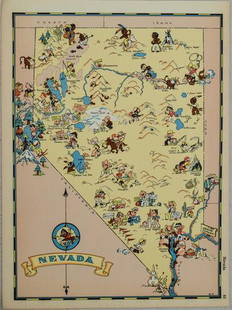
Sold20211938 R Taylor White Pictorial Map of Nevada -- NevadaTitle: 1938 R Taylor White Pictorial Map of Nevada -- Nevada Cartographer: Ruth Taylor White Year / Place: 1938, Boston Map Dimension (in.): 11.6 x 8.5 in. This is Ruth Taylor White's charming pictoriSee Sold Price
Sold2024Siam and the Malay Archipelago. Indonesia Indochina Philippines. TIMES 1895 mapTITLE/CONTENT OF MAP: 'Siam and the Malay Archipelago' DATE PRINTED: 1895 IMAGE SIZE: Approx 38.5 x 25.5cm, 15.25 x 10 inches (Large) TYPE: Antique colour atlas map CONDITION: Good; suitable for framiSee Sold Price
Sold2024The Caucasus. Georgia Armenia Azerbaijan Russia Turkey Iran. THE TIMES 1895 mapTITLE/CONTENT OF MAP: 'The Caucasus' DATE PRINTED: 1895 IMAGE SIZE: Approx 25.5 x 39.5cm, 10 x 15.5 inches (Large) TYPE: Antique colour atlas map CONDITION: Good; suitable for framing. Please check thSee Sold Price
Sold20231855 Beckwith Map of Nevada -- Map No. 3 From the Humboldt Mountains to the Mud Lakes fromTitle: 1855 Beckwith Map of Nevada -- Map No. 3 From the Humboldt Mountains to the Mud Lakes from Explorations and Surveys Made Under the Direction of Hon. Jefferson Davis, Sec. of War… CartograSee Sold Price
Sold20231855 Beckwith Map of Nevada and Northern California -- Map No. 4 From the Valley of the Mud Lakes toTitle: 1855 Beckwith Map of Nevada and Northern California -- Map No. 4 From the Valley of the Mud Lakes to the Pacific Ocean from Explorations and Surveys Made Under the Direction of Hon. Jefferson DSee Sold Price
Sold2022Times Atlas 1895 Map. North Polar RegionsLithograph Map Published 1895, London for "The Times Atlas" Centre fold as published. Paper Size: 21.5 x 16 inch (54 x 41cm) Good ConditionSee Sold Price
Sold20181938 R Taylor White Pictorial Map of Nevada -- NevadaReserve Reduced! Title/Content of Map: 1938 R Taylor White Pictorial Map of Nevada -- Nevada Date: 1938, Boston Cartographer: Ruth Taylor White Size: 11.6 x 8.5 in. This is Ruth Taylor White's charminSee Sold Price
385 Lots AwayPotter & Potter AuctionsLINDGREN, Hjalmer “Jolly” (1895–1952). A Hysterical Map of ...$150(1 bid)
387 Lots AwayPotter & Potter AuctionsLINDGREN, Jolly (1895-1952). A Hysterical Map of Yellowstone Park and the Jackson Hole Country$125
386 Lots AwayPotter & Potter AuctionsLINDGREN, Hjalmer “Jolly” (1895–1952). A Hysterical Map of ...$200
Jun 23Schilb Antiquarian Rare Books1877 Geology Geography Surveys 1ed Nevada Wyoming Utah George Wheeler US West 2v$1
Jun 07Freeman's | HindmanHARDY, Thomas. The Wessex Novels. 1895-97. FIRST UNIFORM AND COLLECTED EDITION.$300
Jun 23Schilb Antiquarian Rare BooksUS War w/ SPAIN 1898 1ed Puerto Rico CUBA Philippines MAPS Russell Illustrated$1


![Rand McNally: Antique Maps of New Orleans/Louisiana: Title/Content of Map: 1895 Rand McNally Maps of New Orleans and Louisiana -- New Orleans [verso] Louisiana Date Printed: 1895, Chicago Cartographer: Rand McNally Size: 11.5 x 9 in. Very nice and highl](https://p1.liveauctioneers.com/5584/115999/59597438_1_x.jpg?height=310&quality=70&version=1517965830)

![Maps of St. Petersburg & Edinburgh, 1895: Map: 1895 Maps of St. Petersburg and Edinburgh -- St. Petersburg (Russia) [verso] Edinburgh Scotland Year / Place: 1895 Map Dimensions: 9.3 x 12 in. Condition: Very good. Nicely colored. Age toning, m](https://p1.liveauctioneers.com/5584/105887/54238253_1_x.jpg?height=310&quality=70&version=1498761257)
![1895 Rand McNally Map of California and [verso] San: Title/Content of Map: 1895 Rand McNally Map of California and [verso] San Francisco Date: 1895, Chicago Cartographer: Rand McNally Size: 11.4 x 9.4 in. An excellent map of California and on reverse, S](https://p1.liveauctioneers.com/5584/149944/75735798_1_x.jpg?height=310&quality=70&version=1568765841)