Sold2016Map of New Zealand, South Island, 1902Title: Map of New Zealand, South Island (Chatham & Tasmania) Original engraving by George Cram Date: 1902 Dimensions: 11 x 14 inches Description: Features insets of Chatham Islands & Tasmania on Van DSee Sold Price
Sold2019Bryce, James 1881 Map of New Zealand South IslandLithograph Map Published 1881, London for ""The International Atlas and Geography..." by James Bryce. Maps by Edward Weller & John Bartholomew. Uncommon. Paper Size: 18 x 13 inch (46 x 33cm) Good CondSee Sold Price
Sold2024Stieler, Adolf 1909 Antique Map. New Zealand - South Sea Islands, Pacific Australia HawaiiLithograph Map Published 1909 by Justus Perthes, Gotha for "Stielers Atlas of Modern Geography" by Adolf Stieler. Center fold as published. Paper Size: 19 x 15.5 inch (48 x 39cm) Good ConditionSee Sold Price
Sold2016Map of New Zealand, North Island, 1902Title: Map of New Zealand, North Island Original engraving by George Cram Date: 1902 Dimensions: 11 x 14 inches No Reserve: This lot starts at $1 and has no reserve as a courtesy so that collectors caSee Sold Price
Sold2020NEW ZEALAND. Shows NZ Company settlements in 1851.TITLE/CONTENT OF MAP: 'New Zealand' Vignettes: Auckland; Mount Egmont from New Plymouth; Wellington. North Island is indicated as "New Ulster or North Island"; the island known today as South Island iSee Sold Price
Sold2024James Cook - Map / Chart Of The Island TahitiEngraved nautical map from the 1774 first French edition of the first map of New Zealand, illustrating Lieutenant James Cook's 1769 exploration of the passage between New Zealand's North and South islSee Sold Price
Sold2024James Cook - Map of Tahiti, the Society Islands, and the VicinityEngraved nautical map from the 1774 first French edition of the first map of New Zealand, illustrating Lieutenant James Cook's 1769 exploration of the passage between New Zealand's North and South islSee Sold Price
Sold2018Pacific OceanTitle/Content of Map: Pacific Ocean Date Printed: 1840-05-15 Cartographer: WALKER, J. & C. Size: 12.2X15.5 Details from the Aleutian Island to Australia/New Zealand and to Cape Horn/South America. DetSee Sold Price
Sold2017Map of New South Wales, 1902Map: New South Wales, 1902 Original engraving from Pictoral Atlas of the World by George Cram, 1902. Dimensions: 11 3/4" x 14 1/2" Please note that this lot has a confidential reserve. When you leaveSee Sold Price
Sold2019Bryce, James 1881 Map of New Zealand North IslandLithograph Map Published 1881, London for ""The International Atlas and Geography..." by James Bryce. Maps by Edward Weller & John Bartholomew. Uncommon. Paper Size: 18 x 13 inch (46 x 33cm) Good CondSee Sold Price
Sold2022Antique Map of Oceania - Map of New Zealand - North Island - John BartholomewAntique map by John Bartholomew & Co for The Edinburgh Geographical Institute. Large chromolithographed map. Technique: Chromolithography. Date: 1880. Artist: John George Bartholomew and Son. Place: ESee Sold Price
Sold2016Reinecke: Australia/ New Zealand/ Hawaii Map 1804Map: Australia/ New Zealand/ Hawaii/ South Pacific "General Charte von Australien" Publishing: Reinecke, Johann Matthias: Weimar Date: 1804 Size: 17.75 x 24 inches An uncommon map described by TooleySee Sold Price
Sold20191855 Colton Map of Hawaii, New Zealand, Oceania IslandsTitle/Content of Map: 1855 Colton Map of Hawaii, New Zealand, Oceania Islands -- Hawaii or Sandwitch Islands [with] Samoan.. [with] New Zealand [with] Viti Group or Feejee Islands [with] Societi IslanSee Sold Price
Sold2018Cedric Savage Watercolor New Zealand LandscapeCedric Savage (New Zealand, 1901 - 1969) framed and matted watercolor painting of a South Island, New Zealand landscape with buildings "Arrowtown", signed lower right, 9 1/2"h x 12"wSee Sold Price
Sold2023New Zealand Silver Pocket Watch (19th Century)Hokitika (South Island) marked pocket watch. Inscribed and dated 1874. Provenance: Providence, Rhode Island estate.See Sold Price
Sold2020Bartholomew, John 1922 Pair Maps. New Zealand & Pacific"New Zealand" and "Islands of Oceania" The latter showing Hawaii and other Pacific Islands. Large Lithograph Maps Published 1922 by The Times, London for "The Times Survey Atlas of the World" Maps bySee Sold Price
Sold2017Weller: Map of Pacific, Hawaii Australia New ZealandTITLE/CONTENT OF MAP: 'The Pacific Ocean'. Sandwich Islands/Hawaii Australia New Zealand This map is folding hence the centrefold line may show on the image below DATE PRINTED: 1862 IMAGE SIZE: ApproxSee Sold Price
Sold2016New South Wales Australia 1814Heading: (Map) Author: Carey, Mathew Title: A New and Accurate Map of New South Wales with Norfolk and Lord Howe's Islands, Port Jackson &c. from Actual Surveys Place Published: Philadelphia PublisherSee Sold Price
Sold2022New Holland & Asiatic islands Australia New Zealand Polynesia THOMSON 1817 mapTITLE/CONTENT OF MAP: 'New Holland and Asiatic islands' DATE PRINTED: Published in 1817. Engraved in 1814; this date is marked on the map IMAGE SIZE: Approx 52.0 x 64.0cm, 20.5 x 25.25 inches (Large);See Sold Price
Sold2024New Zealand Sandwich Galapagos Islands. Papuan Archipelago. Melanesia 1860 mapCAPTION PRINTED BELOW PICTURE: 'New Zealand. // Sandwich Islands, or Hawaiian Group, // Galapagos Islands // Papuan Archipelago' The islands of New Zealand are named with their early colonial and MaorSee Sold Price
Sold2023New Zealand Sandwich Galapagos Islands. Papuan Archipelago. Melanesia 1859 mapNew Zealand. // Sandwich Islands, or Hawaiian Group, // Galapagos Islands // Papuan Archipelago' by John Bartholomew (1859). Antique engraved atlas map with original hand colour/color, 37.0 x 53.5cm,See Sold Price
Sold2017(3) EARLY MAPS and a PRINT AFTER WILLIAM BLAKEIncluding: 1886 Fulton's Territory of Alaska, Hawaiian Group or Sandwich Islands, New Zealand, Feejee Islands, 1867 "The World in Two Hemispheres" by Mitchell (colored) and "The Day of Judgement" prinSee Sold Price
Sold2016Map of Hawaii and New Zealand by Colton, 1855Map features: Hawaiian Group or Sandwich Islands. New Zealand. Viti Group or Feejee Islands. Society Islands. Marquesas or Washington Is. Galapagos Islands. Samoan or Navigators Island. This map is frSee Sold Price
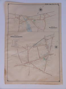
Sold2016Bridgehampton & Watermill, Long Island, 1902Original engraving published by E. Belcher Hyde from "Atlas of Suffolk County, Long Island, New York," Philadelphia, 1902. Map features family names, historic buildings and railroad routes. DimensionsSee Sold Price
Featured2 days LeftJasper521867 Beers Map of New York City Area -- Map of New York and Vicinity Accompanying "Atlas of New York$200
Jun 02Schilb Antiquarian Rare Books1880 Captain James Cook Voyages Hawaii Pacific Australia Kippis South Sea Navy$50(3 bids)
4 days LeftForum AuctionsExecution broadside.- Australia.- More of the Horrors of Transportation: Giving the full Particulars£600
22 hrs LeftMynt Auctions1914 Penrhyn Island Commercial Cover To Hannover Germany Vis New Zealand SG#4$460
Jun 08Leon GalleryVincenzo Maria Coronelli (1650-1718) - Asia Divisa Nelle sue Parti Secondo lo Stato Presente₱220,000
Jun 07Freeman's | Hindman[HARDY, Thomas]. -- WINDLE, C.A. The Wessex of Thomas Hardy. Edmund H. New, illustrator. 1902.$200
Featured2 days LeftJasper521750 Bowen Map of Bermuda and St. Kitts -- A New & Accurate Map of Bermudas or Sommer's Islands...$600
Jun 08Leon GalleryJodocus Hondius 1606 (Jodocus Hondius and Cornelis Claesz) - India Orientalis₱40,000
Featured3 days LeftJasper52South America. New Granada & Venezuela. Colombia Panama. SWANSTON 1860 old map$50
Jun 06Freeman's | HindmanSTEVENSON, Robert Louis (1850-1894). Treasure Island. London, Paris & New York: Cassell & Company,$1,500
Jun 13Heritage Auctions28005: Chaim Gross (American, 1902-1991) Mimi, 1965 Pat$240(1 bid)


![1855 Colton Map of Hawaii, New Zealand, Oceania Islands: Title/Content of Map: 1855 Colton Map of Hawaii, New Zealand, Oceania Islands -- Hawaii or Sandwitch Islands [with] Samoan.. [with] New Zealand [with] Viti Group or Feejee Islands [with] Societi Islan](https://p1.liveauctioneers.com/5584/157856/79675033_1_x.jpg?height=310&quality=70&version=1577197209)


![[HARDY, Thomas]. -- WINDLE, C.A. The Wessex of Thomas Hardy. Edmund H. New, illustrator. 1902. (1 of 3)](https://p1.liveauctioneers.com/197/329395/177650387_1_x.jpg?height=282&quality=70&version=1715364962)


