Sold2022Chickasaw Nation - Indian Territory Homestead Certificatecolorful 6x11 formal document dated 1903 with a bold title printed in red "Homestead Certificate" & bold letters at the bottom "Chickasaw Nation". Issued by Dept. of the Interior from the "Chickasaw LSee Sold Price
Sold2019U.S. Department Of the Interior," U S Geologic SurveyU.S. Department Of the Interior," U S Geologic Survey Map of the Choctaw Nation Indian Territory," c. 1876, H.- 38 1/2 in., W.- 32 5/8 in.See Sold Price
Sold20201887 Map of Indian NationsAuthor: Clare Title: 1887 Map of Indian Nations Medium: Ink on Paper Dimensions: 14"X11.5" Map dated 1887 part of Watson's General Atlas. Engraved by I.S. Clare it captures the Indian Nations territorSee Sold Price
Sold2021Portion of the Map of the Indian Nations and Tribes OfTitle: Portion of the Map of the Indian Nations and Tribes Of The Territory Of Washington and Of The Territory Of Nebraska West Of The Mouth Of The Yellowstone. Catographer: STEVENS, ISAAC INGALLS/WILSee Sold Price
Sold2023Civil War era 1863 map of Mexico & Caribbean nationsLovely and vintage double-page map showing all of Mexico, Central America, Texas, Indian Territory and states of the Deep South during the middle of the American Civil War. Map has an 1860 copyright bSee Sold Price
Sold2021Scarce map of Indian Territory, 1886Most likely the final map of Indian Territory produced by the Colton firm. Map is colored by Indian Nations, and shows a massive Cheyennes and Arapahoes Nation at the top. Over two dozen Native AmericSee Sold Price
Sold20191900 Plat Map of a Section of Cherokee Nation Land --Reserve Reduced! Map Title/Content: 1900 Plat Map of a Section of Cherokee Nation Land -- Cherokee Nation Township 22 North, Range 21 East Cartographer: Indian Territory Map Co. Year / Place: 1900 c.See Sold Price
Sold20181900 Plat Map of a Section of Cherokee Nation Land --Title/Content of Map: 1900 Plat Map of a Section of Cherokee Nation Land -- Cherokee Nation Township 22 North, Range 21 East Date: 1900 c. Muskogee, Ind. Terr. Cartographer: Indian Territory Map Co. SSee Sold Price
Sold2022Uncommon map of Oklahoma & Indian Terr., 1897Unusual wax engraved map of Oklahoma Territory/Indian Territory ten years before the region achieved statehood. Numerous Indian nations located throughout. Shows railroads with routes named, towns, riSee Sold Price
Sold20151901 Map showing progress of allotment in Indian CreekMap showing progress of allotment in Creek Nation- Exhibit, col,. comp. and drawn by C.H. Dana. NY: U.S. Department of the Interior, Julius Bien Photo Lithograph, 190120 mile scaleDimensions: 24 1/4"See Sold Price
Sold2021Creek and Seminole Nations Indian Territory. ShowingPublication Date: c1904 Title: Creek and Seminole Nations Indian Territory. Showing Progress of Allotments Cartographer: DANA, C. H. Publisher: U.S. DEPARTMENT OF THE INTERIOR. COMMISSION TO THE FIVESee Sold Price
Sold20222 US Deeds -Cherokee Nation & New York (Albany)2 US Deeds -Cherokee Nation & New York (Albany)1906 Allotment Deed Cherokee Nation Indian Territory - this is an allotment deed signed on July 18, 1906 by the commissioner to the five civilized tribesSee Sold Price
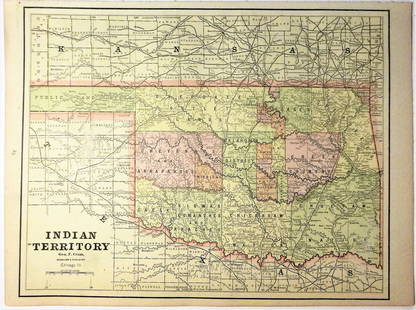
Sold2020Indian Territory 1891Title/Content of Map: Indian Territory 1891 Date Printed: 1891 Material/Medium: Paper Size: approx 10.5x14.5 inches Additional Info: Cram's Atlas of the World. Geo. F. Cram, Chicago Reserve: $20.00 SSee Sold Price
Sold2020Indian Territory 1897Title/Content of Map: Indian Territory 1897 Date Printed: 1897 Material/Medium: paper Size: approx. 11x 13.5 inches Additional Info: Cram's Universal Atlas Reserve: $30.00 Shipping: Domestic: Flat-ratSee Sold Price
Sold2021Government map of Indian TerritoriesHeading: (Indian Territory) Author: Dinsmore, A. F., Lowe, R.P., Naylor, William, Cartographers Title: Indian Territory. Department of The Interior General Land Office. Hon. Thomas H. Carter, CommissiSee Sold Price
Sold20181890 Census Office Map of Indian Territory and OklahomaTitle/Content of Map: 1890 Census Office Map of Indian Territory and Oklahoma -- Map of Indian Territory and Oklahoma Date: 1890, Washington Cartographer: General Land Office / Census Office Size: 22.See Sold Price
Sold202119th C. Map of Indian Territory & 20th C. Kachina**Originally Listed At $300** Map: "Map of Indian Territory Drawn and Engraved on Copper Plate Expressly for Johnson's Cyclopedia" - Volume IV New York - A.J. Johnson Company, ca. 1880 to 1894. FigureSee Sold Price
Sold2020Map of Indian TerritoryTitle/Content of Map: Map of Indian Territory Date: 1899 Cartographer: U.S. GEOLOGICAL SURVEY Publisher: U.S.G.S. Size: 32.5Height - 29.5Width showing distribution of woodland. Compiled under the direSee Sold Price
Sold2021Map of Indian Territory & KansasMap of Indian Territory Combined with Map of Kansas on Verso Color Map Dated: 19th century Dimensions: 10 x 6 1/2" Condition Report Good. TextSee Sold Price
Sold2016Map of Indian Territory and Oklahoma, J. Bein 1890Title: Map of Indian Territory and Oklahoma Subject: Oklahoma Maker: J. Bein Date: 1890, New York Size: 22.5 x 29.5 inches Map of the Indian Territory showing areas ceded to various tribes, each withSee Sold Price
Sold20181883 General Land Office Map of Indian TerritoryTitle/Content of Map: 1883 General Land Office Map of Indian Territory -- Indian Territory Date Printed: 1883, Washington Cartographer: General Land Office Size: 12 x 16 in. This is a highly detailedSee Sold Price
Sold2018Asher & Adams: Antique Map of Indian Territory, 1874Title/Content of Map: 1874 Asher & Adams Indian Territory Map -- Asher & Adams Indian Territory and Texas North West Portion Date Printed: 1874, New York Cartographer: Asher & Adams Size: 16.3 x 23.2See Sold Price
Sold2017Asher & Adams: Map of Indian Territory, 1874Map: Hand Colored Map of Indian Terratory Maker: Asher & Adams Date: 1874 Size: Approx. 16x22 inches First edition of this large format railroad map of IndianTerritory, from Asher & Adams' Atlas of thSee Sold Price
Jun 12Dan Morphy AuctionsMAP OF THE CHOCTAW NATION, INDIAN TERRITORY - COAL AND ASPHALT SEGREGATION 1903$150
Jun 12Dan Morphy AuctionsMAP OF THE CHOCTAW NATION, INDIAN TERRITORY - COAL AND ASPHALT SEGREGATION 1903$100
May 30NY Elizabeth 1792 OLD INDIA HISTORY ANTIQUE ILLUSTRATED WITH MAPS OF THE EIGHTEENTH CENTURY IN FRENCH$50
Jun 12Dan Morphy AuctionsPLATE CXIII. MAP OF INDIAN TERRITORY SHOWING DISTRIBUTION OF WOODLAND” FROM THE TWENTY-FIRST$100
4 days LeftJasper521898 Rand McNally Map of Texas [verso] Indian Territory and Oklahoma -- Texas [verso] Oklahoma and$70
4 days LeftJasper521887 Cram Map of Texas [verso] Indian Territory [verso] Arkansas -- Texas [verso] Indian Ty. [verso]$95
Jun 12Dan Morphy AuctionsINDIAN TERRITORY - DEPARTMENT OF THE INTERIOR GENERAL LAND OFFICE, C.1883$100
May 21BonhamsJoseph Davey Cunningham, A History of the Sikhs, from the Origin of the Nation to the Battles of...£1,600
5 days LeftJasper52Central Europe. Germany Poland Czechoslovakia Carpathian Ruthenia TIMES 1922 map$30
Jun 02Schilb Antiquarian Rare Books1886 INDIANS 1ed Sa-Go-Ye-Wat-Ha Red Jacket Seneca Revolutionary War Hubbard$1


![1898 Rand McNally Map of Texas [verso] Indian Territory and Oklahoma -- Texas [verso] Oklahoma and (1 of 2)](https://p1.liveauctioneers.com/5584/328338/176911581_1_x.jpg?height=282&quality=70&version=1715113718)
![1887 Cram Map of Texas [verso] Indian Territory [verso] Arkansas -- Texas [verso] Indian Ty. [verso] (1 of 3)](https://p1.liveauctioneers.com/5584/328338/176911685_1_x.jpg?height=282&quality=70&version=1715113718)


![(2) Comanche Portraits by Lenny & Sawyers [Cabinet Card] (1 of 2)](https://p1.liveauctioneers.com/7226/322253/173251539_1_x.jpg?height=282&quality=70&version=1710004847)


