Sold2017Map of the State of New York by J. DenisonCirca 1796 Antique Map, Title: Map of the State of New York by J. Denison. A. Doolittle (sculp.) Approximate size: 10-5/8" x 8-3/8". Please note that this lot has a confidential reserve. When you leavSee Sold Price
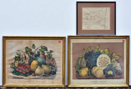
Sold2020Two Currier & Ives PrintsAutumn Fruits and Summer Fruits each 15 1/2" x 19" stone lithographs and a Map of the State of New York by J. Denison, published by Thomas & Andrews, Boston, 1796See Sold Price
Sold2018NEW YORK STATE MAP, J.H. FRENCH 1860NEW YORK STATE MAP, J.H. FRENCH 1860 W. 73 1/2" H. 64"See Sold Price
Sold2023An 1860 Map of New York State by J.H. French and an 1846 Mitchell's Reference & Distance Map of theAn 1860 Map of New York State by J.H. French and an 1846 Mitchell's Reference & Distance Map of the United States by J.H. Young58 x 72 1/2 inchesOther Notes: Fontaine's Auction Gallery can arrange shiSee Sold Price
Sold2017Map of the States of New Hampshire & VermontCirca 1796 Antique Map Title: "Map of the States of New Hampshire and Vermont". Citation: by J. Denison. Amos Doolittle, Sculp. Approximate size: 10-3/8" x 8-3/8". Please note that this lot has a confSee Sold Price
Sold2022Lloyd's official map of the State of Tennessee, 1863LLOYD, James T. (19th Century). and Charles A. REEVES.Lloyd's official map of the State of Tennessee, 1863. Folding lithographed map with original stencilled color. New York: J.T. Lloyd, 1863. 32" x 4See Sold Price
Sold2019[Map, Large] Lloyd's Map of the Southern States 1862"Lloyd's Map of the Southern States Showing all the Railroads, their Stations & Distances… 1862." New York: J. T. Lloyd, [1862.] Colored by state. Large map, measured from neatlines 51.25" x 37". CoSee Sold Price
Sold2020SMITH, J. CALVIN. Map of the State of New York.SMITH, J. CALVIN. Map of the State of New York. Engraved map of New York state with three inset maps. 19¾x25¼ inches sheet size; hand-colored in outline; issued folding, now flat and mountedSee Sold Price
Sold2021A group of five American state and city maps,A group of five American state and city maps, comprising: Wisconsin. Philadelphia: Thomas, Cowperthwait & Co., N.d. 19 1/2 x 17 1/8 In. -- Ohio. New York: J.H. Colton, 1855. 17 1/2 x 20 1/2 In. Some gSee Sold Price
Sold2019State of Pennsylvania. from the latest Surveys.Title/Content of Map: State of Pennsylvania. from the latest Surveys. Date: 1796 Cartographer: D. Martin Publisher: J. Reid Size: 12.75Height - 18Width Published by J. Reid New York. Professionally clSee Sold Price
Sold2022Colored 1827 map of New York with Erie Canal and another.Map of the State of New York, published by A. Finley, Philad[elphi]a, 1827. J. H. Young, sc. Strong thin paper map, hand colored as issued, showing the Erie Canal (completed little more than one yearSee Sold Price
Sold2020Railroad & Township Map of New YorkHeading: Author: Colton, J.H. Title: Colton's Railroad & Township Map of the State Of New York. With Parts of the Adjoining States & Canada Place Published: New York Publisher:Colton & Company DSee Sold Price
Sold20242 19th Century New York Maps Gamble & Colton2 19th century maps of New York. Colton's Map of New York and the Adjacent Cities, J.H. Colton 1855, 16 1/4" x 26 1/4" (with frame 28 1/8" x 38"); County Map of the State of New York, W.H. Gamble, 187See Sold Price
Sold2019Johnson's New York Maps [New York State, NYC]Two Johnson's New York Maps, one of New York City and Brooklyn, the other of New York State. Alvin Jewett Johnson Cartographer. Published by A. J. Johnson, New York. Stamped 'Entered according to ActSee Sold Price
Sold2022J.H. COLTON (1800-1893) A MAP, "New Map of the State ofJ.H. COLTON (1800-1893) A MAP, "New Map of the State of Texas," NEW YORK, CIRCA 1855, hand-colored lithograph on paper, "Compiled from J. de Cordova's large Map," and, "Published by J.H. Colton & Co.,See Sold Price
Sold2017LOT (3) EARLY POCKET BOOK MAPS C.1830'sLOT (3) EARLY POCKET BOOK MAPS INCL. H/C STATE OF NEW YORK BY HUMPHREY PHELPS,1833, 16" X 21", STATE OF NEW JERSEY BY J. LOW, C. 1830, 10 1/2" X 7 1/2", STATE OF PENNSYLVANIA BY A. FINLEY, C. 1830, 9"See Sold Price
Sold2022Map of "The State of Massachusetts from the Best Information 1796"Map of "The State of Massachusetts from the Best Information 1796," hand colored copper engraving, published by J. Reid, New York from John Reid's American Atlas the second folio-sized atlas publishedSee Sold Price
Sold2020The State of New York Map 1861J. H. French The State of New York Map, 1861, Robert Persoll Smith, Publisher. Has been shellacked, has significant cracking at the right edge, center bottom and top edge. Top bar is coming loose. MeaSee Sold Price
Sold2018J. H. Colton's Map of United StatesIncluding US, British Provinces, Mexico, and West Indies. Published by J.H. Colton, New York, 1853. 59" x 53".See Sold Price
Sold20241865 United States Map by ColtonTitle: 1865 United States Map by Colton Date/Period: 1865 Materials: Hand colored steel engraved Size: 12 x 9" The United States, with Mexico and the Caribbean, 1865 By J. H. Colton. New York. Hand-coSee Sold Price
Sold2019Colton's Ohio Map [Midwestern States]Colton's Ohio Map. J. H. Colton Cartographer. Inset of 'Vicinity of Cleveland' lower right. Published by J. H. Colton, New York. Stamped 'Entered according to Act of Congress in the Year 1855 by J. H.See Sold Price
Sold2019Colton's Virginia Map [Southern States]Colton's Virginia Map; Delaware on the right, Maryland on the left. J. H. Colton Cartographer. Published by J. H. Colton, New York. Stamped 'Entered according to Act of Congress in the Year 1855 by J.See Sold Price
Sold2019Colton's Iowa Map [Midwestern States]Colton's Illinois Map. J. H. Colton Cartographer. Published by J. H. Colton, New York. Stamped 'Entered according to Act of Congress in the Year 1855 by J. H. Colton and Co. in in the Clerks Office ofSee Sold Price
Sold2019Colton's Delaware/Maryland Map [Southern States]Colton's Delaware and Maryland Map; Delaware on the right, Maryland on the left. J. H. Colton Cartographer. Published by J. H. Colton, New York. Insert of 'District of Columbia' lower left. Stamped 'ESee Sold Price
Featured13 hrs LeftJasper521867 Beers Map of New York City Area -- Map of New York and Vicinity Accompanying "Atlas of New York$200
Jun 08Simpson Galleries, LLC.J.H. Young (1792-1870) AN AMERICAN FEDERAL PERIOD MAP, "Mitchell's Travellers Guide Through the$500
Jun 06Freeman's | HindmanPYNCHON, Thomas (b. 1937). V. Philadelphia and New York: J. B. Lippincott, 1963.$200
Jun 06Freeman's | HindmanLEE, Harper (1926-2016). To Kill A Mockingbird. Philadelphia & New York: J.B. Lippincott Company,$3,000
3 hrs LeftPapps Family Liquidation1.16 Ctw SI2/I1 Diamond 14K Rose Gold Express your Country/ state love New York Necklace$500
13 hrs LeftJasper521874 Holmes Plan of New York's Upper East Side -- Map of the Common Lands from 76th to 93rd Street$750
Jun 06Rapid Estate Liquidators and Auction Gallery1856 Mississippi Map & Info Published By J.H. Colton & Co. No.172 William St. New York$5


![[Map, Large] Lloyd's Map of the Southern States 1862: "Lloyd's Map of the Southern States Showing all the Railroads, their Stations & Distances… 1862." New York: J. T. Lloyd, [1862.] Colored by state. Large map, measured from neatlines 51.25" x 37". Co](https://p1.liveauctioneers.com/3532/154050/77745068_1_x.jpg?height=310&quality=70&version=1572759985)


![Colored 1827 map of New York with Erie Canal and another.: Map of the State of New York, published by A. Finley, Philad[elphi]a, 1827. J. H. Young, sc. Strong thin paper map, hand colored as issued, showing the Erie Canal (completed little more than one year](https://p1.liveauctioneers.com/1066/241373/125137826_1_x.jpg?height=310&quality=70&version=1648068277)


![Johnson's New York Maps [New York State, NYC]: Two Johnson's New York Maps, one of New York City and Brooklyn, the other of New York State. Alvin Jewett Johnson Cartographer. Published by A. J. Johnson, New York. Stamped 'Entered according to Act](https://p1.liveauctioneers.com/5755/154409/77936949_1_x.jpg?height=310&quality=70&version=1573094011)


![Colton's Ohio Map [Midwestern States]: Colton's Ohio Map. J. H. Colton Cartographer. Inset of 'Vicinity of Cleveland' lower right. Published by J. H. Colton, New York. Stamped 'Entered according to Act of Congress in the Year 1855 by J. H.](https://p1.liveauctioneers.com/5755/154409/77936939_1_x.jpg?height=310&quality=70&version=1573094011)
![Colton's Virginia Map [Southern States]: Colton's Virginia Map; Delaware on the right, Maryland on the left. J. H. Colton Cartographer. Published by J. H. Colton, New York. Stamped 'Entered according to Act of Congress in the Year 1855 by J.](https://p1.liveauctioneers.com/5755/154409/77936948_1_x.jpg?height=310&quality=70&version=1573094011)
![Colton's Iowa Map [Midwestern States]: Colton's Illinois Map. J. H. Colton Cartographer. Published by J. H. Colton, New York. Stamped 'Entered according to Act of Congress in the Year 1855 by J. H. Colton and Co. in in the Clerks Office of](https://p1.liveauctioneers.com/5755/154409/77936937_1_x.jpg?height=310&quality=70&version=1573094011)
![Colton's Delaware/Maryland Map [Southern States]: Colton's Delaware and Maryland Map; Delaware on the right, Maryland on the left. J. H. Colton Cartographer. Published by J. H. Colton, New York. Insert of 'District of Columbia' lower left. Stamped 'E](https://p1.liveauctioneers.com/5755/154409/77936946_1_x.jpg?height=310&quality=70&version=1573094011)


![[STEREOS] EARLY NY STATE. LOT OF 7 SOLD TOGETHER (1 of 2)](https://p1.liveauctioneers.com/8124/329803/177770658_1_x.jpg?height=282&quality=70&version=1715634941)


