Sold2024Martin, Benjamin 1772 Map. Nature of Geographical Maps and ProjectionsCopper Engraved Map Published 1772, London for "The Young Gentleman and Lady's Philosophy... by Benjamin Martin. Vertical fold as issued. Paper Size: 8 x 5 inch (21 x 13cm) Good ConditionSee Sold Price
Sold2023Martin, Benjamin 1772 Antique Map. Atlantic Ocean with Europe Africa America"A New Geographical Map or Chart of the Atlantic Ocean with the Continents of Europe, Africa & America &c on the East & West Side of it" Copper Engraved Map Published 1772, London for "The Young GentlSee Sold Price
Sold2023Martin, Benjamin 1772 Antique Map. Atlantic Ocean with Europe Africa America"A New Geographical Map or Chart of the Atlantic Ocean with the Continents of Europe, Africa & America &c on the East & West Side of it" Copper Engraved Map Published 1772, London for "The Young GentlSee Sold Price
Sold2023Martin, Benjamin 1772 Astronomy Celestial Map. Course of the Solar Maculae over the Sun's DiskCopper Engraved Map Published 1772, London for "The Young Gentleman and Lady's Philosophy... by Benjamin Martin. Vertical Fold as issued. Paper Size: 8 x 7 inch (21 x 18cm) Good ConditionSee Sold Price
Sold2023Martin, Benjamin 1772 Astronomy Celestial Map. ConstellationsCopper Engraved Map Published 1772, London for "The Young Gentleman and Lady's Philosophy... by Benjamin Martin. Paper Size: 8 x 5 inch (21 x 13cm) Good ConditionSee Sold Price
Sold2023Martin, Benjamin 1772 Astronomy Celestial Map. The Transit of VenusCopper Engraved Map Published 1772, London for "The Young Gentleman and Lady's Philosophy... by Benjamin Martin. Paper Size: 8 x 5 inch (21 x 13cm) Good ConditionSee Sold Price
Sold2023Martin, Benjamin 1772 Astronomy Celestial Map. Beginning & End of the Egress of VenusCopper Engraved Map Published 1772, London for "The Young Gentleman and Lady's Philosophy... by Benjamin Martin. Paper Size: 8 x 5 inch (21 x 13cm) Good ConditionSee Sold Price
Sold2021Guthrie, William 1798 Map World of Mercators ProjectionCopper Engraved Map Published 1798, London for "A New Geographical, Historical and Commercial Grammar..." by William Guthrie. The maps are by John Senex, Thomas Kitchin and others. Folds as issued. PaSee Sold Price
Sold2022Guthrie, William 1805 Map. World on Mercators ProjectionCopper Engraved Map Published 1805, London for "A New Geographical, Historical and Commercial Grammar..." by William Guthrie. Folds as issued. Paper Size: 10.5 x 8 inch (27 x 21cm) Approx. Some toningSee Sold Price
Sold2022Guthrie, William 1812 Map. World on Mercator's ProjectionCopper Engraved Map Published 1812, London for "A New Geographical, Historical and Commercial Grammar..." by William Guthrie. Folds as issued. Paper Size: 14 x 8 inch (36 x 21cm) Approx. Some toning/oSee Sold Price
Sold2023Lizars, Daniel 1831 LG Rare HC Map. World on Mercator's ProjectionLarge Folio Copper Engraved Map Published 1831-2 by John Hamilton, Successor to Daniel Lizars, Edinburgh for "The Edinburgh Geographical and Historical Atlas..." First Edition by Daniel Lizars. Very fSee Sold Price
Sold2017Bowen: Antique Map of East Indies, 1772Map: East Indies Publication Date: 1772 Authors: G. ROBINSON, BOWEN, T. Publisher: G. ROBINSON Size: Miniature – 7.00 H x 11.10 W Inches "by Thos. Bowen geogr. Engraved for Jones's Geographical GramSee Sold Price
Sold2018* BELLIN, Jacques Nicholas (1703-1772). Essay d'une* BELLIN, Jacques Nicholas (1703-1772). Essay d'une Carte Reduite, Contenant les Parties Connuees du Globe Terrestre. Paris, 1748. Engraved map of the world on Mercator's projection, image 500 x 700 mSee Sold Price
Sold2023Map of the United States of America, John Melish,Philadelphia, H. C. Corey & I. Lea, 1822, engraved by Benjamin Tanner, had colored from a complete historical, chronological and geographical American atlas. Sight size 17" x 22", in a high quality moSee Sold Price
Sold2016Album of the Lands of the Bible - Map of Eretz IsraelAlbum of the lands of the Bible, 50 original views of important places mentioned in scripture, drawn from nature by Johann Martin Bernatz. Stuttgart-Leipzig: J.L. Steinkopf, 1858. English, German andSee Sold Price
Sold2022Islamic, Middle Eastern Geographical Map Of Mecca With Arabic Calligraphy.Islamic, Middle Eastern Geographical Map Of Mecca With Arabic Calligraphy. Size of page 16 x 11 1/4 inches. Fine Map of Mecca with hand written Arabic calligraphy on paper. Ex Private Los Angeles, CASee Sold Price
Sold2015Modern Aluminum Wall Sculpture of USA MapAmerican, 20th century. Modern aluminum metal wall sculpture depicting a geographical map rendering of the United States of America with incised borders demarcating states. Flattened sculptural map wiSee Sold Price
Sold2022Stephanie Woolley (b. 1954, NM), "Peregrine andStephanie Rentschler Woolley (b. 1954, New Mexico), "Peregrine and Kestrel" original watercolor over "Birds of Europe" geographical map dated 1850 image: 12 x 9", frame: 19 x 16" Stephanie Woolleys enSee Sold Price
Sold2022New atlas of universal geography in 52 cardsMilan, Batelli and Fanfani, [1820]. In 2nd. Unnumbered plate with armillary sphere, 50 numbered geographical maps of which many large folded, all in fine period coloring, missing the front door with tSee Sold Price
Sold2016Geographical Statistical Historical Michigan Map, 1822Map: Geographical, Statistical and Historical Map of Michigan Territory Cartographer: Carey & Lea Publishing: Philadelphia, 1822 Size: 17 x 21.8 inches This is the first map only focused on Michigan TSee Sold Price
Sold20171832 Aspin - North & South America...[proposed state ofTitle: North & South America; for the Elucidation of the Abbe Gaultier's Geographical Games "Map maker: Jehoshaphat Aspin, A Complete Course Of Geography..." "Place and Year: Paris, 1832" "Dimensions:See Sold Price
Sold2022(BRITISH EMPIRE.) George Philip & Son, Ltd.; and The London Geographical Institute. Navy League Map(BRITISH EMPIRE.) George Philip & Son, Ltd.; and The London Geographical Institute. Navy League Map of the British Empire. Oversize chromolithograph map of the world delineating early 20th-century BriSee Sold Price
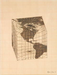
Sold2021Agnes Denes - Study of Distortions; Isometric SystemsLot 3 Agnes Denes Hungarian/American (b. 1931) Study of Distortions; Isometric Systems in Isotropic Space-Map Projections: The Cube (1975) gouache and ink on graph paper and mylar signed lower right sSee Sold Price
Sold2021Tennessee Map, Lucas, Carey, & Lea, 1822GEOGRAPHICAL, STATISTICAL, AND HISTORICAL MAP OF TENNESSEE drawn by Fielding Lucas, Jr., engraved by William Kneass, from A COMPLETE HISTORICAL, CHRONOLOGICAL, AND GEOGRAPHICAL AMERICAN ATLAS, publishSee Sold Price
Featured4 days LeftJasper521831 Woodbridge Map of South America and Africa -- Comparative, Geographical & Statistical Map of$70
4 days LeftJasper52Map of the World Showing the Geographical Distribution & Range of The Principal Members Of The$45


![New atlas of universal geography in 52 cards: Milan, Batelli and Fanfani, [1820]. In 2nd. Unnumbered plate with armillary sphere, 50 numbered geographical maps of which many large folded, all in fine period coloring, missing the front door with t](https://p1.liveauctioneers.com/3796/250546/130126095_1_x.jpg?height=310&quality=70&version=1654521704)