Sold2017Mitchell Map of the Dakotas, Wyoming, etc, 1871Title: 1871 Mitchell Map of the Dakotas, Wyoming, Colorado, Nebraska and Kansas Cartographer: S Mitchell Published: 1871, Philadelphia Measurements: 19.8 X 14.8 in. County Map of Dakota, Wyoming, KansSee Sold Price
Sold20181871 Mitchell Map of Dakotas, Nebraska, Kansas,Title/Content of Map: 1871 Mitchell Map of Dakotas, Nebraska, Kansas, Colorado and Wyoming -- County Map of Dakota, Wyoming, Kansas, Nebraska and Colorado Date: 1871, Philadelphia Cartographer: S MitcSee Sold Price
Sold20201876 Mitchell Map of Colorado, Wyoming, Dakotas,Title/Content of Map: 1876 Mitchell Map of Colorado, Wyoming, Dakotas, Nebraska, and Montana -- County Map of Colorado, Wyoming, Dakota, Montana Date: 1876 Philadelphia Cartographer: S Mitchell Size:See Sold Price
Sold2022Scarce map of NW territories, Hardesty 1875Scarce regional map of the Wyoming Territory, Montana Territory, Dakota Territory and Nebraska, colored by counties and showing towns, mountains, rivers, railroads, etc. One of the few maps to show WySee Sold Price
Sold2023Map of Kan. Neb. Col. Dak. Et al, Mitchell 1872Great mid-continent map; shows Montana with just 2 counties, Wyoming with only 5 counties and early images of Colorado and Dakota. Shows the Little Big Horn area just four years before General CusterSee Sold Price
Sold20181871 Mitchell Map of Texas -- XIII TexasTitle/Content of Map: 1871 Mitchell Map of Texas -- XIII Texas Date Printed: 1871, Philadelphia Cartographer: S Mitchell / Butler Co. Size: 8.3 x 10.5 in. This is very nice map of Texas, part of a schSee Sold Price
Sold2017Hardesty: Antique Map Nebraska Dakota Montana WyomingScarce 1875 Hardesty map of Nebraska, Dakota, Montana & Wyoming. From the scarce Jones and Hamilton Illustrated Historical Atlas of the World Illustrated. Large format hand-colored map shows TerritorySee Sold Price
Sold20181871 Mitchell Antique Map of AlaskaTitle/Content of Map: 1871 Mitchell Map of Alaska -- North Western America Showing the Territory Ceded by Russia to the United States Date Printed: 1871, Philadelphia Cartographer: S Mitchell Size: 11See Sold Price
Sold2018Mitchell: Antique Map of New Orleans, 1871Title/Content of Map: 1871 Mitchell Map of New Orleans -- Plan of New Orleans Date Printed: 1871, Philadelphia Cartographer: S Mitchell Size: 9.3 x 10.9 in. An excellent map of the Crescent City, showSee Sold Price
Sold20231871 Mitchell's Map of Kentucky and Tennessee -- County Map of Kentucky and TennesseeTitle: 1871 Mitchell's Map of Kentucky and Tennessee -- County Map of Kentucky and Tennessee Cartographer: S Mitchell Year / Place: 1871, Philadelphia Map Dimension (in.): 10.5 X 13.5 This is a ratherSee Sold Price
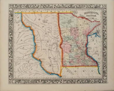
Sold20201860 Mitchell Map of Minnesota and the DakotasTitle/Content of Map: 1860 Mitchell Map of Minnesota and the Dakotas --Minnesota and Dacotah Date: 1860, Philadelphia Cartographer: S Mitchell Size: 10.6 X 13.3 in. This is a rather nice map of MinnesSee Sold Price
Sold20231866 Johnson Map of Nebraska, Dakotas, Idaho, Montana and Wyoming-- Johnson's Nebraska, Dakota,Title: 1866 Johnson Map of Nebraska, Dakotas, Idaho, Montana and Wyoming-- Johnson's Nebraska, Dakota, Idaho and Montana Cartographer: Johnson & Ward Year / Place: 1866, New York Map Dimension (in.):See Sold Price
Sold2017Johnson: Map of Nebraska Dakota Idaho Montana, 1866Johnson’s Nebraska, Dakota, Idaho and Montana , Johnson & Ward, 1866. 17 x 23.25 inches. Significant and scarce Johnson map of Idaho, Montana, Wyoming, Dakota and Nebraska. The first Johnson map toSee Sold Price
Sold2017McNally: Map of Wyoming Nebraska Kansas Dakota, 1875Map: Wyoming, Nebraska, Kansas, Dakota, Colorado, and Montana Date: 1875 Size: 12 x 10 inches From McNally's "System of Geography Atlas". Please note that this lot has a confidential reserve. When youSee Sold Price
Sold20201869 Mitchell Map of Plains States and Colorado --Title/Content of Map: 1869 Mitchell Map of Plains States and Colorado -- XVIII Kansas, Colorado, New Mexico and Indian Territory [verso] XVI Minnesota and Dakota [also] XVII Nebraska Cartographer: S MSee Sold Price
Sold2017Johnson: Antique Map Nebraska Dakota Idaho MontanaJohnson’s Nebraska, Dakota, Idaho and Montana, c1865. One of the earliest appearances of Wyoming on a map -- so early, it has not been added to the map title. Pre-dates Yellowstone. Wyoming is in aSee Sold Price
Sold2024Civil War era map of N. America with unsettled state bordersOne of the key maps in the 1860s Johnson series of North America. In this map Idaho Territory encompasses what would eventually become Idaho, Montana and Wyoming. Dakota Territory has yet to split intSee Sold Price
Sold2022Civil War era map of N. America with unsettled state bordersOne of the key maps in the 1860s Johnson series of North America. In this map Idaho Territory encompasses what would eventually become Idaho, Montana and Wyoming. Dakota Territory has yet to split intSee Sold Price
Sold2021(7) 1980s Burlington Northern State Railroad MapsGreat lot of vintage maps from Burlington Northern. Each come with original sleeve and original envelope mailer. Oregon/California, Washington/Idaho, Illinois, Wyoming, North Dakota, Nebraska/Kansas aSee Sold Price
Sold2022Nice map of Asia from S. A. Mitchell, Jr. – 1860sMap of Asia Showing its Political Divisions and also the Various Routes of Travel Between London & India, China & Japan, etc. Detailed map of Asia, colored by country. Full and original hand coloring.See Sold Price
Sold2021U. S. & N. America w/odd Dakota--Ettling c1860This uncommon Civil War era engraved map shows a very unusual configuration for Dakota. In this map the borders of Wyoming and Utah have yet to be finalized. Numerous Indian tribes are located throughSee Sold Price
Sold2023[DAKOTA]. The Mercantile Agency Reference Book (And Key) with A List of Banks and Bankers, State[DAKOTA]. The Mercantile Agency Reference Book (And Key) with A List of Banks and Bankers, State Collection Laws, Maps, Etc. New York: R. G. Dun & Co., 1908. Square 8vo. Two maps of North Dakota printSee Sold Price
Sold2023An 1860 Map, Counties of New York, New Hampshire, Etc...Hand colored lithograph, by Samuel Augustus Mitchell (1790-1868). :County Map of the States of New York, New Hampshire, Vermont, Massachusetts, Rhode Island and Connecticut". Dimensions:15 1/2" x 23 1See Sold Price
Sold2021[Vandermaelen, Phillipe M.G.] Montana, Wyoming Map[Vandermaelen, Phillipe M.G.] map of portions of present day Montana, Wyoming, North & South Dakota. Measures 21.75-in. x 29.25-in. sheet size. [Brussells: c.1827]. G/G-VG condition. If lot is absentSee Sold Price
3 days LeftHolabird Western Americana CollectionsAtlas Maps Report of Fortieth Parallel c1876 (14) [181041]$300
Jun 11Jasper521872 Mitchell Map of Massachussetts, Connecticut and Rhode Island -- County Map of Massachussetts,$40
Jun 11Jasper521878 Mitchell Map of Georgia and Alabama -- County Map of the States of Georgia and Alabama$50
2 days LeftHolabird Western Americana CollectionsWyoming History (3) 1899 & 1955 Reprints [182275]$200
Jun 11Jasper52County and Township Map of the States of Massachusetts, Connecticut and Rhode Island$40
BonhamsMITCHELL (SAMUEL AUGUSTUS) Mitchell's New General Atlas, Containing Maps of the Various Countrie...£500
Crawford Family Auctions LLC24 pcs Vintage Philatelic Stamp Collecting Book Collection. Airpost Catalogues. See pics.$21(2 bids)
3 days LeftHolabird Western Americana CollectionsNevada City, CA Map, etc. c1930s-50s (3) [180880]$75
3 hrs LeftThe Scanlan CollectionPicturesque California, by John Muir, Volume 3, Imperial Japan Edition$1,000
4 days LeftSimpson Galleries, LLC.J.H. Young (1792-1870) AN AMERICAN FEDERAL PERIOD MAP, "Mitchell's Travellers Guide Through the$500
2 days LeftHolabird Western Americana CollectionsPioneer Years in the Black Hills by Hughes, 1st Edition [182212]$100
3 days LeftHolabird Western Americana CollectionsAtlas Pages Stark Cty, OH & Townships . c1870-1900's. [180168]$50


![1869 Mitchell Map of Plains States and Colorado --: Title/Content of Map: 1869 Mitchell Map of Plains States and Colorado -- XVIII Kansas, Colorado, New Mexico and Indian Territory [verso] XVI Minnesota and Dakota [also] XVII Nebraska Cartographer: S M](https://p1.liveauctioneers.com/5584/179983/90569362_1_x.jpg?height=310&quality=70&version=1601417445)


![[DAKOTA]. The Mercantile Agency Reference Book (And Key) with A List of Banks and Bankers, State: [DAKOTA]. The Mercantile Agency Reference Book (And Key) with A List of Banks and Bankers, State Collection Laws, Maps, Etc. New York: R. G. Dun & Co., 1908. Square 8vo. Two maps of North Dakota print](https://p1.liveauctioneers.com/197/290824/154051809_1_x.jpg?height=310&quality=70&version=1685134375)

![[Vandermaelen, Phillipe M.G.] Montana, Wyoming Map: [Vandermaelen, Phillipe M.G.] map of portions of present day Montana, Wyoming, North & South Dakota. Measures 21.75-in. x 29.25-in. sheet size. [Brussells: c.1827]. G/G-VG condition. If lot is absent](https://p1.liveauctioneers.com/5755/206309/104802119_1_x.jpg?height=310&quality=70&version=1622662726)
![Atlas Maps Report of Fortieth Parallel c1876 (14) [181041] (1 of 6)](https://p1.liveauctioneers.com/2699/331495/178785770_1_x.jpg?height=282&quality=70&version=1717094933)


![Wyoming History (3) 1899 & 1955 Reprints [182275] (1 of 3)](https://p1.liveauctioneers.com/2699/331494/178785555_1_x.jpg?height=282&quality=70&version=1717094654)


![Black Hills by Dodge, 1876 [182213] (1 of 5)](https://p1.liveauctioneers.com/2699/331494/178785454_1_x.jpg?height=282&quality=70&version=1717094654)


![Nevada City, CA Map, etc. c1930s-50s (3) [180880] (1 of 4)](https://p1.liveauctioneers.com/2699/331495/178785751_1_x.jpg?height=282&quality=70&version=1717094933)

![Foreign Interest Books c1863-1906 (4) [179682] (1 of 9)](https://p1.liveauctioneers.com/2699/331494/178785475_1_x.jpg?height=282&quality=70&version=1717094654)


![Pioneer Years in the Black Hills by Hughes, 1st Edition [182212] (1 of 6)](https://p1.liveauctioneers.com/2699/331494/178785455_1_x.jpg?height=282&quality=70&version=1717094654)


![Atlas Pages Stark Cty, OH & Townships . c1870-1900's. [180168] (1 of 6)](https://p1.liveauctioneers.com/2699/331495/178785794_1_x.jpg?height=282&quality=70&version=1717094933)