Sold2021Mudie, Robert 1841 Map. Rivers & MountainsSteel Engraved Map/Chart Published 1841, London for "Gilbert's Modern Atlas of the Earth" by Robert Mudie. Drawn and Engraved by Russell and Archer. Scarce. Paper Size: 13 x 10.5 inch (33 x 27cm) EdgeSee Sold Price
Sold2021Mudie, Robert 1841 Map. Waterfalls & LakesSteel Engraved Map/Chart Published 1841, London for "Gilbert's Modern Atlas of the Earth" by Robert Mudie. Drawn and Engraved by Russell and Archer. Scarce. Paper Size: 13 x 10.5 inch (33 x 27cm) EdgeSee Sold Price
Sold2017Rand McNally: Antique World Map, Rivers & MountainsMap: Rand McNally World Map and Comperative Chart of Rivers and Mountains -- The World on Mercator's Projection [verso] Western Hemisphere Cartographer: Rand McNally Year / Place: 1898, Chicago Map DiSee Sold Price
Sold2020Mudie, Robert 1841 Lot of 8 Hand Col Bird PrintsHand Colored Etchings Published 1841, London for "The Feathered Tribes of the British Islands" by Robert Mudie. Paper Size: 8 x 5 inch (20 x 13cm) Good ConditionSee Sold Price
Sold2020Mudie, Robert 1841 Lot of 11 Hand Col Bird Prints9 Prints plus 2 Illustrated Title Pages. Hand Colored Etchings Published 1841, London for "The Feathered Tribes of the British Islands" by Robert Mudie. Paper Size: 8 x 5 inch (20 x 13cm) Good ConditiSee Sold Price
Sold2021Principal Rivers & Mountains 1901Title/Content of Map: Principal Rivers & Mountains 1901 Date Printed: 1901 Material/Medium: Paper Size: approx 10.5x13.5 inches Fort Dearborn Publ. Co., The National Standard Atlas Reserve: $25.00 ShiSee Sold Price
Sold2021Dramatic map of greatest rivers & mountains, 1855Fascinating graphic map presentation showing the principal mountains and rivers in the World, with legends on either side identifying the rivers and mountains, including several active volcanoes. SpecSee Sold Price
Sold2017Clouet: Map of Lakes, Rivers & Mountains of Asia, 1780Title/Content of Map: 'Lacs, Fleuves, Rivieres, et Principales Montagnes de L'Asie.' A map of the Lakes, Rivers and Mountains of Asia DATE PRINTED: 1780 IMAGE SIZE: Approx 34.5 x 57.0cm, 13.75 x 22.5See Sold Price
Sold2022New Brunswick, Nova Scotia, Newfoundland, etc. - 1863Wonderful large and vintage map of Canada’s Maritime Provinces just a couple of years before the confederation of Canada. The map identifies forts, rivers, mountain passes, coastal features, toSee Sold Price
Sold2017Colton: Antique Map of Mountains & Rivers, 1869Premium example of Colton’s Mountains & Rivers, 1869 (undated). Gorgeous and clean large format example of the Colton mountains and rivers plate, showing the lengths of the principal rivers of the wSee Sold Price
Sold2018Antique Map of Lengths of Rivers and Mountains, 1843Title/Content of Map: Lengths of Rivers and Mountains Date Printed: 1843 Cartographer: Based on the work of H.C. Tanner Material/Medium: Paper Size: 17" x 14" Hand colored engraved Map. From the firstSee Sold Price
Sold2017Gray World Map, Mountains and Rivers, 1875Map: Gray World Mountains and Rivers - Mountains and Rivers Cartographer: O Gray Date: 1875 Origin: Philadelphia Size: 16.4 x 25 inches A very handsome and colorful double-page chart showing the majorSee Sold Price
Sold20211835 1st ed Mudie Earth Science Geology Geography1835 1st ed Mudie Earth Science Geology Geography Mountains America Africa Robert Mudie was a 19th-century English journalist who took a special interest in ornithology and earth sciences. One of MudiSee Sold Price
Sold2018mountains and rivers from Johnson's family atlasMap: mountains and rivers from Johnson's family atlas Date: 1862 Cartographer: coulton and johnson Material: paper Dimensions: 26.75"wide x 18"high one of the larger johnson atlases printed No ReserveSee Sold Price
Sold2023South America (Relief). Rivers Mountains 1907 old antique map plan chartTitle: South America (Relief). Rivers Mountains 1907 old antique map plan chart Description: South America (Relief)' by Scientific American (1907). Vintage colour map, 21.0 x 17.5cm, 8.25 x 7 inches;See Sold Price
Sold20201855 Johnston World Map with Comperative Chart ofTitle/Content: 1855 Johnston World Map with Comperative Chart of Rivers and Mountains -- The World in Hemispheres, with Comparative Views of the Heights of ths Principal Mountains and Lengths of the PSee Sold Price
Sold20191875 Gray Mountains and Rivers Chart -- Mountains andTitle/Content of Map: 1875 Gray Mountains and Rivers Chart -- Mountains and Rivers Date: 1875, Philadelphia Cartographer: O Gray Size: 16 X 25 in. This is a handsome double-page chart showing the majoSee Sold Price
Sold2023Scarce map of the Upper Midwest by J. David WilliamsScarce regional map of the Upper Midwest and Iowa, hand colored by counties at the time of publishing. Shows railroad lines, towns, mountains, rivers, and more. This map shares a long-running collaborSee Sold Price
Sold2024Radefeld: South America—Mountain & River SystemsTitle/Content of Map: Radefeld: South America—Mountain & River Systems Date Printed: 1856, Hildburghausen Cartographer: Radefeld / Bibliographisches Instituts Size: 14 1/4" x 11 1/2 " A beautifuSee Sold Price
Sold2018Cram: Antique Map of Tallest Mountains, Longest RiversTitle/Content of Map: 1886 Cram Map of Tallest Mountains and Longest Rivers -- Principal Mountains of the World and Principal Rivers of the World Date Printed: 1886, Chicago Cartographer: G Cram Size:See Sold Price
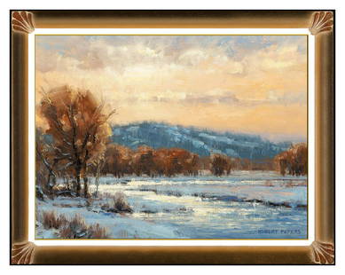
Sold2022Robert Peters Original Oil Painting On Board River Mountain Landscape Signed ArtThis lot includes:Gallery COA & free domestic shipping (*insurance and international shipping for an additional charge)Artist: Robert PetersTitle: Gentle Hours Medium: Oil Painting On BoardSize: 9" xSee Sold Price
Sold2023Robert Peters Original Oil Painting On Board River Mountain Landscape Signed ArtThis lot includes: Gallery COA & free domestic shipping (*insurance and international shipping for an additional charge)Artist: Robert PetersTitle: Gentle HoursMedium: Oil Painting On BoardSize: 9" xSee Sold Price
Sold20181892 Cram Map of Tallest Mountains and Longest RiversReserve Reduced! Title/Content of Map: 1892 Cram Map of Tallest Mountains and Longest Rivers -- Principal Mountains of the World and Principal Rivers of the World Date: 1892, Chicago Cartographer: G CSee Sold Price
Sold2017Cram: Map of Alaska verso W Hemisphere, 1901Map: 1901 Cram Map of Alaska [verso] Comparison of Rivers and Mountains in Western Hemisphere Maker: G Cram Published: 1901, Chicago, New York Size: 12.8 x 19.9 in A very nice map of Alaska with greatSee Sold Price
4 days LeftJasper521671 Ogilby Map of Venezuela -- Venezuela, cum Parte Australi Novae Andalusiae$160
5 days LeftCedarburg Auction & Appraisals LLCSet of Four Maps Showing All of Spain and Portugal$375(2 bids)
5 days LeftJasper52AMAZONIA showing "El Dorado?" & Missions. Brazil Ecuador Colombia SDUK 1874 map$120
5 days LeftJasper52AMAZONIA.Showing "El Dorado?", missions & tribes. Brazil Ecuador.SDUK 1844 map$130
12 hrs LeftTrillium Antique Prints & Rare BooksWilkes - 4 Engravings of Trees & Mountains in Nu?uanu Pali, Hawaii / Upolu, Samoa / New South Wales,$100


![Rand McNally: Antique World Map, Rivers & Mountains: Map: Rand McNally World Map and Comperative Chart of Rivers and Mountains -- The World on Mercator's Projection [verso] Western Hemisphere Cartographer: Rand McNally Year / Place: 1898, Chicago Map Di](https://p1.liveauctioneers.com/5584/108569/55677982_1_x.jpg?height=310&quality=70&version=1504123318)


![Cram: Map of Alaska verso W Hemisphere, 1901: Map: 1901 Cram Map of Alaska [verso] Comparison of Rivers and Mountains in Western Hemisphere Maker: G Cram Published: 1901, Chicago, New York Size: 12.8 x 19.9 in A very nice map of Alaska with great](https://p1.liveauctioneers.com/5584/102085/52141912_1_x.jpg?height=310&quality=70&version=1490997744)


