Sold2018Natolia, Quae Olim Asia Minor. Mid-1600s. Map.[Middle East] Natolia, Quae Olim Asia Minor. Mid-1600s. Double-page map of Turkey, from the Euphrates to the Aegean and Cyprus. Engraved decorations: cartouche, scale, Naval battle, ocean creature. FrSee Sold Price
Sold2019Natolia quae olim Asia Minor Old MapBlaeu's decorative map of Asia Minor, showing Turkey, Cyprus and the Islands in the Aegean. This attractive map shows all of Turkey, Cyprus and the Aegean Islands to a relatively high degree of accuraSee Sold Price
Sold2016Natolia, quae olim Asia minor by Joannis Blaeu 1650Map Title: Natolia, quae olim Asia minor Artist: Joannis Blaeu Publisher: Guiljelmum Blaeu, Amsterdam Date: 1650 Size: 15 x 19.5 inches Medium: Hand colored copper plate engraving A beautiful map of TSee Sold Price
Sold2017Natolia quae olim Asia Minor, 16401640 Natolia quae olim Asia Minor. By: Willem Janszoon BlaeuDate: 1640 (circa) Amsterdam. Dimensions: 15 x 19.75 inches (38.1 x 50.2 cm) This is an authentic antique map of Asia Minor that includes CySee Sold Price
Sold2020Historical map of Turkey, OttHistorical map of Turkey, Ottoman Empire, ''Natolia quae olim Asia Minor'', border col. Engraving at Schenk around 1700, center fold deposited at the edge with a tear, 39 x 49 cm, behind PP 50 x 60 cmSee Sold Price
Sold20191598 Ortelius Map of Turkey, Egypt and Carthage --Title/Content of Map: 1598 Ortelius Map of Turkey, Egypt and Carthage -- Natoliae, quae olim Asia Minor Nova Descriptio [on sheet with] Aegypti Recentior Descriptio [and] Carthaginis Celeberrimi SinusSee Sold Price
Sold20191595 Ortelius Map of Turkey, Egypt and Carthage --Reserve Reduced! Map Title/Content: 1595 Ortelius Map of Turkey, Egypt and Carthage -- Natoliae, quae Olim Asia Minor, Nova Descriptio [on sheet with] Aegypti Recentior Descriptio [and] Carthaginis CeSee Sold Price
Sold2017Ortelius: Three maps of the Near EastThree maps printed from a single engraved plate, from Theatrum Orbis Terrarum, Antwerp, 1598: "'Natoliae, Quae Olim Asia Minor, Nova Descriptio;" "Aegypti Recentior Descriptio …;" "and "CarthaginisSee Sold Price
Sold2018Ortelius, Abraham. Natoliae, Quae Olim Asia Minorcopperplate engraving with outline color, from Theatrum Orbis Terrarum, circa 1600, showing Asia Minor, Crete, and Cyprus; Latin text en verso; presented in carved gilt wooden frame. DOA 18 x 25.25 inSee Sold Price
Sold2024Abraham Ortelius Natoliae, Quae Olim Asia Minor, Nova DescriptioRemoved from Latin edition Ortelius Atlas 1595 edition (Theatrum Orbis Terrarum), Hand coloredSee Sold Price
Sold2017Janssonius: Antique Map of Portugal, 1645Title: Portugallia et Algarbia quae olim Lusitania. Attractive mid-17th century map of Portugal Map maker: Jan Janssonius Place and Year: Amsterdam, [c.1645] Dimensions: 38.5 x 49.5 cm (15¼ x 19½ inSee Sold Price
Sold2022(ANATOLIA.) Pierre Mortier. Natolia. Asia Minor Auctore Phi. de la Rue.(ANATOLIA.) Pierre Mortier. Natolia. Asia Minor Auctore Phi. de la Rue. Large folio engraved map of Turkey, Cyprus and coastal Syria. 20¼x24¾ inches sheet size, wide margins, blank verso; orSee Sold Price
Sold202418th century MAP of ARMENIA GEORGIA NATOLIA BLACK SEA ASIA MINOR antiqueby I.Senex Overall size 9.5 by 14" Very good condition, folds Reserve: $70.00 Shipping: Domestic: Flat-rate of $25.00 to anywhere within the contiguous U.S. International: Foreign shipping rates are dSee Sold Price
Sold20241630 Natolie Sive Asia Minor Mercator Mapearly map of Turkey in Asia, published in Amsterdam by Gerard MercatorSee Sold Price
Sold2018ASIA MINOR. Turkey Anatolia. Shows Smyrna/Izmir-AydinTITLE/CONTENT OF MAP: 'Asia Minor' The map shows the first railway line constructed in Anatolia (and opened a couple of years prior to the publication of the map in 1860), between Smyrna (Izmir) and ASee Sold Price
Sold2021UNFRAMED ANTIQUE MAP OF ASIA MINOR , HOMANN HEIRS, 1743"Carte de L'Asie Minevre ou de la Natolie et du Pont Evxin Tiree des Voyages et des Observations de Anciens et Modernes,...Heretiers de Homann. Nuremb.". Hand colored copperplate engraving. Unframed,See Sold Price
Sold2018Mallet: Antique Map of Asia Minor with Black Sea, 1683Title of the Map: 'Natolie' Shows the Black sea & Cyprus. Asia Minor Turkey. Black Sea Cyprus Rhodes. Date Printed: 1683 Image Size: Approx Overall page size 13 x 21cm approximately (5 x 8 inches); imSee Sold Price
Sold2022TURKISH EMPIRE AND ASIA MINOR SPEED (JOHN) The Turkish Empire, 1676; and 7 other maps of Turkish...TURKISH EMPIRE AND ASIA MINOR SPEED (JOHN) The Turkish Empire, double-page engraved map, 8 city views (including Constantinople, Damascus, Jerusalem and Alexandria) in upper border, 10 costumed figurSee Sold Price
Sold2022THREE HAND-COLORED MAPSTHREE HAND-COLORED MAPS1) “Insulae Indiae Orientalis” from the Mercator/Hondius Atlas Minor, Mid-16th Century. 6” x 7.75” sight. Framed 12.25” x 14.25”.2) "DeSee Sold Price
Sold2017Rare Anatolian Anthropomorphic Bronze IdolAsia Minor, northern Anatolia (Turkey) or Transcaucasia (Armenia, Azerbaijan, and Georgia), ca. mid- to late 3rd millennium BCE. A unique cast bronze anthropomorphic idol with the body composed of bulSee Sold Price
Sold2017Mercator (Gerard) - Atlas sive Cosmographicae,Editio Quinta, engraved pictorial title, prelims, 49 double-page maps, including Asia, Russia, Turkey, Lithuania, Asia Minor and Persia, regions of Italy Spain, Germany and Eastern Europe, and 11 singSee Sold Price
Sold201916th century Natolie Sive Asie Minor Mercator Map16th Century fine early map of Turkey in Asia, published in Amsterdam by Gerard Mercator. Strapwork cartouche at lower right. Two more cartouches, one shows scales, the other has a Latin inscription.See Sold Price
Sold2017Hondius Map of IndiaIndia quae Orientalis dicitur et Insulae Adiacentes. Henricus Hondius (1597-1651). Copperplate engraving. Amsterdam, c. 1636. 17 x 21 3/4 inches sheet. An important Dutch map of South East Asia, notewSee Sold Price
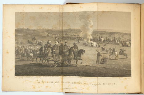
Sold2022WITTMAN, WILLIAM. Travels in Turkey, Asia-Minor, Syria, and Across the Desert into Egypt, durin...WITTMAN, WILLIAM. Travels in Turkey, Asia-Minor, Syria, and Across the Desert into Egypt, during the years 1799, 1800, and 1801.... London: Richard Phillips, 1803. 4o (265 x 210 mm). Engraved foldingSee Sold Price
Jun 08Leon GalleryAbraham Ortelius (1527 - 1598) - Indiae Orientalis (Philippines/China/ India/ Southeast Asia)₱200,000
18 hrs LeftForum Auctionsd'Anville (Jean Baptiste Bourguignon) [Untitled Composite Atlas with 102 map sheets], [probably£2,000
42 Lots AwayHermann Historica GmbHA Roman marble gravestone of a venator, 3rd century A.D.See Sold Price
Jun 18DOYLE Auctioneers & AppraisersA block puzzle with maps of Europe, England, Ireland, Scotland, America and the World$100
5 hrs LeftThousand Planet Auction HouseLot of Vintage Mid-20th Century South Asian Mosaic Glass Beads, c. 1940s-1960s$10


![Natolia, Quae Olim Asia Minor. Mid-1600s. Map.: [Middle East] Natolia, Quae Olim Asia Minor. Mid-1600s. Double-page map of Turkey, from the Euphrates to the Aegean and Cyprus. Engraved decorations: cartouche, scale, Naval battle, ocean creature. Fr](https://p1.liveauctioneers.com/179/122672/62428340_1_x.jpg?height=310&quality=70&version=1527272450)


![1598 Ortelius Map of Turkey, Egypt and Carthage --: Title/Content of Map: 1598 Ortelius Map of Turkey, Egypt and Carthage -- Natoliae, quae olim Asia Minor Nova Descriptio [on sheet with] Aegypti Recentior Descriptio [and] Carthaginis Celeberrimi Sinus](https://p1.liveauctioneers.com/5584/147595/74587407_1_x.jpg?height=310&quality=70&version=1565730371)
![1595 Ortelius Map of Turkey, Egypt and Carthage --: Reserve Reduced! Map Title/Content: 1595 Ortelius Map of Turkey, Egypt and Carthage -- Natoliae, quae Olim Asia Minor, Nova Descriptio [on sheet with] Aegypti Recentior Descriptio [and] Carthaginis Ce](https://p1.liveauctioneers.com/5584/135277/68682133_1_x.jpg?height=310&quality=70&version=1548808491)


![Janssonius: Antique Map of Portugal, 1645: Title: Portugallia et Algarbia quae olim Lusitania. Attractive mid-17th century map of Portugal Map maker: Jan Janssonius Place and Year: Amsterdam, [c.1645] Dimensions: 38.5 x 49.5 cm (15¼ x 19½ in](https://p1.liveauctioneers.com/5584/110975/56961897_1_x.jpg?height=310&quality=70&version=1508432804)


![[MAP]. ORTELIUS, Abraham. Romani Imperii Imago. 1592. (1 of 2)](https://p1.liveauctioneers.com/197/329395/177650537_1_x.jpg?height=282&quality=70&version=1715364962)


![d'Anville (Jean Baptiste Bourguignon) [Untitled Composite Atlas with 102 map sheets], [probably (1 of 3)](https://p1.liveauctioneers.com/5458/329231/177514974_1_x.jpg?height=282&quality=70&version=1715269091)


