Sold2019Nice 1860 map of AfricaMap of Africa, Showing Its Most Recent Discoveries (with Inset of the Island of St. Helena). Full hand coloring. 1860 date; from 1866 Mitchell New General Atlas. Good impression. Foxed heavily in margSee Sold Price
Sold2022Nice 1860 map of Maine with full hand coloringVery nice vintage map of Maine with original hand coloring by county. Features signature floral border that makes Mitchell maps stand apart. Railroads clearly delineated and named. Shows coastal featuSee Sold Price
Sold2022Rapkin, John 1860 Antique Map. Africa ContinentSteel Engraved Map Published 1860 by The London Printing & Published Company, London for "The Royal Dictionary-Cyclopedia for Universal Reference" by Thomas Wright. Drawn & Engraved by John Rapkin. FoSee Sold Price
Sold20191831 Teesdale Map of Africa -- AfricaTitle/Content of Map: 1831 Teesdale Map of Africa -- Africa Date: 1831, LondonCartographer: H Teesdale Size: 16.1 X 13.2 in. This is a very nice map of Africa.Plenty of detail is offered mostly alongSee Sold Price
Sold20181839 Mitchell Map of Africa -- No. 25 Map of AfricaTitle/Content of Map: 1839 Mitchell Map of Africa -- No. 25 Map of Africa Date: 1839, Philadelphia Cartographer: S Mitchell Size: 8.1 x 10.1 in. A quite nice map of Africa, showing that much of the inSee Sold Price
Sold2018Smith/Burgess: Antique Map of Africa, 1835Title/Content of Map: 1835 Smith/Burgess Map of Africa -- Africa Date Printed: 1835, Hartford Cartographer: C Smith / D Burgess Size: 8.7 x 10.4 in. This is a very nice map of Africa from the early 19See Sold Price
Sold20221851 Tallis Map of North Africa -- Northern AfricaTitle: 1851 Tallis Map of North Africa -- Northern Africa Cartographer: J Tallis Year / Place: 1851, London Map Dimension (in.): 10 x 12.5 in. Thisd is a very nice map of North Africa, including TunisSee Sold Price
Sold20181851 Tallis Map of North Africa -- Northern AfricaTitle/Content of Map: 1851 Tallis Map of North Africa -- Northern Africa Date: 1851, London Cartographer: J Tallis Size: 10 x 12.4 in. A very nice map of North Africa, including Tunisia, Algeria and MSee Sold Price
Sold20241833 Goodrich Map of Africa -- AfricaTitle: 1833 Goodrich Map of Africa -- Africa Cartographer: S Goodrich Year / Place: 1833 c. Map Dimension (in.): 7.1 X 9.2 in. This is a very nice Atlas map of Africa. The continent's regions are coloSee Sold Price
Sold20181882 Brockhaus Map of South Africa -- Karte derTitle/Content of Map: 1882 Brockhaus Map of South Africa -- Karte der Kapstaaten Date: 1882 Leipzig Cartographer: F Brockhaus Size: 11 x 8.4 in. A very nice map of South Africa, with great deal of polSee Sold Price
Sold20221855 Colton Map of Southern Africa -- Africa Southern SheetTitle: 1855 Colton Map of Southern Africa -- Africa Southern Sheet Cartographer: J Colton Year / Place: 1855, New York Map Dimension (in.): 11.8 X 15.3 in. This is a very nice map of southern Africa iSee Sold Price
Sold2019Rapkin, John 1860 Pair of Maps of Africa, South Africa"Africa" and "Cape Colony" Steel Engraved Map Published 1860 by The London Printing & Published Company, London for "The Royal Dictionary-Cyclopedia for Universal Reference" by Thomas Wright. Drawn &See Sold Price
Sold20201866 McNally Map of Africa -- AfricaTitle/Content of Map: 1866 McNally Map of Africa -- Africa Date: 1866 Chicago Cartographer: M McNally Size: 10.8 x 8.5 in. A very nice and informative map of Africa, with color coded countries. Many oSee Sold Price
Sold2017McNally: Map of Africa, 1866Map: 1866 McNally Map of Africa -- Africa Cartographer: M McNally Year/Place: 1866 Chicago Dimensions: 10.8 x 8.5 in. A very nice and informative map of Africa, with color coded countries. Many of todSee Sold Price
Sold2023Excellent 1860 map of Baltimore by Samuel A. Mitchell, Jr.Nice example of Samuel Augustus Mitchell Jr’s map of Baltimore with the vivid outline hand coloring that sets this edition off from other editions. Shows wonderful detail at the street level, inSee Sold Price
Sold20221855 Colton Map of Northeastern Africa -- Africa North Eastern SheetTitle: 1855 Colton Map of Northeastern Africa -- Africa North Eastern Sheet Cartographer: J Colton Year / Place: 1855, New York Map Dimension (in.): 14.6 X 12 in. This is a very nice map of northeastSee Sold Price
Sold20221855 Colton Map of Western Africa -- Africa North Western SheetTitle: 1855 Colton Map of Western Africa -- Africa North Western Sheet Cartographer: J Colton Year / Place: 1855, New York Map Dimension (in.): 14.9 X 13 in. This is a very nice map of north and westSee Sold Price
Sold20241750 Bellin Map of South Africa's Saldana Bay -- Carte de la Baye de Saldana ou SaldaneTitle: 1750 Bellin Map of South Africa's Saldana Bay -- Carte de la Baye de Saldana ou Saldane Cartographer: J Bellin Year / Place: 1750, Paris Map Dimension (in.): 8.1 X 11.1 in. This is a nice map oSee Sold Price
Sold20221574 Ruscelli Map of Northern Africa -- Africa Minor Nuova TavolaTitle: 1574 Ruscelli Map of Northern Africa -- Africa Minor Nuova Tavola Cartographer: G Ruscelli Year / Place: 1574, Venice Map Dimension (in.): 7.1 X 9.6 in. This is a very nice Ptolemaic map of norSee Sold Price
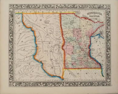
Sold20201860 Mitchell Map of Minnesota and the DakotasTitle/Content of Map: 1860 Mitchell Map of Minnesota and the Dakotas --Minnesota and Dacotah Date: 1860, Philadelphia Cartographer: S Mitchell Size: 10.6 X 13.3 in. This is a rather nice map of MinnesSee Sold Price
Sold20191860 Mitchell Map of Baltimore -- Plan of BaltimoreTitle: 1860 Mitchell Map of Baltimore -- Plan of Baltimore Date: 1860, Philadelphia Cartographer: S Mitchell Size: 9 X 11.2 in. Additional Information: A very nice map of Baltimore, identifying the vaSee Sold Price
Sold2017McNally: Antique Map of Africa, 1866Map: 1866 McNally Map of Africa -- Africa Date/Place: 1866 Chicago Cartographer: M McNally Size: 10.8 x 8.5 in. Condition: Very Good. Clear imression, nice coloring. Slight toning. A very nice and infSee Sold Price
Sold20241798 Faden Map of Africa -- Africa According to the Latest ExplorationsTitle: 1798 Faden Map of Africa -- Africa According to the Latest Explorations Cartographer: W Faden Year / Place: 1798, London Map Dimension (in.): 3.9 X 4.4 in. This is a very nice compact map of AfSee Sold Price
Sold2022Antique Map of Africa - Morocco - Madagascar - Angola - Zimbabwe - UgandaAntique map of Africa by Becker, published in London, c 1860. This antique map was engraved by the omnigraph method by Francis Paul Becker & Company, Patentees circa 1842, with contemporary hand colouSee Sold Price
Featured2 days LeftJasper52Africa. Mauritius, Bourbon (Reunion) & Natal by Edward Weller 1860 old map$55
2 days LeftJasper52Africa inc. discoveries of Livingstone Barth Vogel Chadda Exp. SWANSTON 1860 map$120
Featured18 hrs LeftJasper521831 Woodbridge Map of South America and Africa -- Comparative, Geographical & Statistical Map of$70(1 bid)
Featured18 hrs LeftJasper521884 Johnson Map of Washington Oregon and Idaho -- Johnson's Washington Oregon and Idaho$100
3 days LeftHolabird Western Americana CollectionsDelaware & Hudson Canal Co Pass 1896 [180459]$50(1 bid)
3 days LeftHolabird Western Americana CollectionsDelaware & Hudson Canal Pass 1894 [180455]$50(1 bid)
18 hrs LeftJasper521754 but early 1800s Delagrive Map of Paris Environs in Reduced Size -- Reduction des neuf feuilles$60
2 days LeftJasper52COLONIAL AFRICA. British French German Italian Portugal Spain.STANFORD 1906 map$15
2 days LeftJasper52AFRICA shows 1911 Neukamerun border changes. Equatorial cross section 1912 map$30(1 bid)


![Delaware & Hudson Canal Co Pass 1896 [180459] (1 of 2)](https://p1.liveauctioneers.com/2699/331495/178785924_1_x.jpg?height=282&quality=70&version=1717094933)


![Delaware & Hudson Canal Pass 1894 [180455] (1 of 2)](https://p1.liveauctioneers.com/2699/331495/178785925_1_x.jpg?height=282&quality=70&version=1717094933)


![Delaware & Hudson Co Pass 1906 [180454] (1 of 2)](https://p1.liveauctioneers.com/2699/331495/178785926_1_x.jpg?height=282&quality=70&version=1717094933)


