Sold2024North East Africa. Egypt Abyssinia Arabia Abu Dhabi Sharja. COLTON 1869 mapTITLE OF MAP (NOT PRINTED ON THE PAGE):'Africa - north eastern sheet' DATE PRINTED: 1869 IMAGE SIZE: Approx 42.0 x 33.5cm, 16.5 x 13.25 inches (Large) TYPE: Antique engraved hand coloured atlas map COSee Sold Price
Sold2020Middle East.- Roberts (David) The Holy Land, Syria,Middle East.- Roberts (David) The Holy Land, Syria, Idumea, Arabia, Egypt, & Nubia, 6 vol. in 3, 248 tinted lithograph plates (including titles) and 2 engraved maps, occasional light foxing, corner ofSee Sold Price
Sold2022Middle East.- Roberts (David) The Holy Land, Syria,Middle East.- Roberts (David) The Holy Land, Syria, Idumea, Arabia, Egypt & Nubia, 6 vol. in 3, portrait frontispiece, 6 pictorial lithograph titles, 241 tinted lithographs, 2 maps, tissue guards, mosSee Sold Price
Sold2020THEODORE GUDIN'S 19TH CENTURY PAINTINGTheodore Gudin was a French 19th Century painter who was born in 1802. Theodore Gudin is featured in Sotheby's Annual Orientalist Sale, Features Paintings Representing North Africa, Egypt, Arabia, theSee Sold Price
Sold20215 Large Islamic Egyptian Fustat Glass BeadsNorth Africa, Egypt, Fustat, Islamic culture, ca. 7th to 11th century CE. A wonderful ensemble of 5 sizeable glass beads, each presenting a barrel form and formed using the mosaic glass technique. EacSee Sold Price
Sold2021c 1730 Seutter Map: Novi Belgii, in America ...Historic Maps c. 1730 Historic Rare Earlier State of Seutter's Important American Northeast Map & New York City Restitutio View c. 1730 Hand-Colored Copper-Engraved Map titled, "Recens Edita totius NoSee Sold Price
Sold2022Iraqw Beaded Skirt, 20th C, Tanzania.A Iraqw Beaded Skirt. Beads, natural fibers, and animal hide. North central Tanzania, East Africa. Frame: 61 5/8" x 38 3/4". Iraqw skirts are amongst the most elaborately decorated textiles from easteSee Sold Price
Sold2021FRAMED J.H. COLTON MAP OF NORTH AMERICA CA INSETFramed engraving on paper, Map of North America from the Latest Authorities, published by J.H. Colton (Joseph Hutchins Colton, 1800-1893), No. 86 Cedar St., New York, 1846, drawn and engraved by J.M.See Sold Price
Sold2020[Maps & Atlases] [Africa] Ortelius, Abraham, Group of 2[Maps & Atlases] [Africa] Ortelius, AbrahamGroup of 2 MapsBarbariae et Biledulgerid, nova descriptio(Antwerp, ca. 1570-1612). Hand-colored engraving. Coastal map of North Africa and the Mediterranean,See Sold Price
Sold2021Big Game Hunting in Sudan 1906Heading: Author: Jessen, B.H. Title: W.N. McMillan's Expeditions and Big Game Hunting in Sudan, Abyssinia, & British East Africa Place Published: London Publisher:Marchant Singer & Co. Date PubSee Sold Price
Sold2021Dutch Nicolaes Visscher I Map of New Amsterdam, ca 1690Nicolaes Visscher I. Map of Northeast with Early View of New York City. Ca. 1690 to 1729. A finely hand-colored example of Nicolaes Visscher I's illustrated map of the Northeast of America with an insSee Sold Price
Sold2020Engraved Map of the East Coast of AmericaJacques-Nicolas Bellin (1703-1772), "Carte Reduite des Costes Orientales de L'Amerique Septentrionale," Paris, 1757. Hand colored engraved map of the northeast coast of North America, showing what isSee Sold Price
Sold2022Middle East.- Saudi Arabia.- Saudi Aramco (publisher) Collection of maps and ephemera from compiledMiddle East.- Saudi Arabia.- Saudi Aramco (publisher) and others. Collection of maps and ephemera compiled by a British Engineer working in the Middle East, including 5 laminated maps of Saudi Arabia,See Sold Price
Sold2022LOT OF INTERNATIONAL COINS.This lot contains approximately 345 coins from Cyprus, Egypt, Czechoslovakia, Denmark, West India, East Africa and others. Around 75 silver coins.See Sold Price
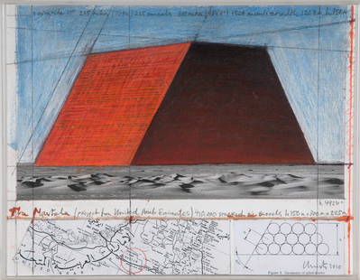
Sold2016CHRISTO & JEANNE-CLAUDE: "ABU DHABI MASTABA""ABU DHABI MASTABA (PROJECT FOR UNITED ARAB EMIRATES)"circa 2010 pencil, charcoal, oil stick, collaged aerial map and photograph on board signed and dated verso Provenance: The Estate of David Copley,See Sold Price
Sold2022DES BARRES, JOSEPH FREDERICK WALLET The North East Shore of the Gulph of Mexico. London: circa 1780.DES BARRES, JOSEPH FREDERICK WALLET The North East Shore of the Gulph of Mexico. London: circa 1780. A very large hand-colored engraved map on four joined sheets. Overall 30 x 84 inches (76 x 214 cm).See Sold Price
Sold2015De Bry (Theodore) - Descriptio Hydrographicathe 2-sheet map of Africa and Asia, from the east coast of Brazil to Japan, charting the first Dutch voyage to the East Indies by Houtman, large titlecartouche upper centre of right sheet, ships, compSee Sold Price
Sold20222-sheet map of ancient Egypt by Ortelius 1584Heading: Author: Ortelius, Abraham Title: Aegyptus Antiqua Place Published: Antwerp Publisher: Date Published: 1584 Description: Copper engraved map on two sheets, north anSee Sold Price
Sold2018South East Asia.- Ortelius (Abraham) Indiae OrientalisSouth East Asia.- Ortelius (Abraham) Indiae Orientalis Insularumque Adiacientium Typus, map of southern Asia from India across to Java and New Guinea, and including China and Japan to the north, withSee Sold Price
Sold2023ERWIN ROMMEL NORTH AFRICA PRESENTATION TRENCH ARTAn important historic object, a British 25-pounder shell casing transformed into a presentation award given to general and future Field Marshal ERWIN ROMMEL (1891-1944) by a division of his men in NorSee Sold Price
Sold2024A LARGE NISHAPUR "HAWK" KUFIC INSCRIBED POTTERY DISH NORTH-EAST IRAN, 10TH CENTURYA LARGE NISHAPUR "HAWK" KUFIC INSCRIBED POTTERY DISH NORTH-EAST IRAN, 10TH CENTURY Diameter:35cm Property of a Canadian Private CollectionSee Sold Price
Sold2023North AfricaUshabti made of turquoise faience in the name of Horiu. Late Period, 26th - 30th dynasty, 664 - 332 BC. Height 13,8cm. On the back side pillar with hieroglyphics Osiris, Horiu, born to Hab Basteteru .See Sold Price
Sold2018Colton Map of Nebraska and KansasCOLTON, Joseph H. (1800-1893). Nebraska & Kansas. Lithograph with handcolor in part. New York, 1857. 30 1/2 x 22 1/2 inches sheet, 40 x 32 inches framed Striking map of Kansas and Nebraska, includingSee Sold Price
Sold2022(FLORIDA PANHANDLE.) Joseph Frederick Wallet des Barres. The North East Shore of the Gulph of(FLORIDA PANHANDLE.) Joseph Frederick Wallet des Barres. The North East Shore of the Gulph of Mexico. Large engraved coastal chart of western Florida from Apalachicola to Mobile Bay. 4 sheets of "LVG"See Sold Price
4 days LeftJasper521816 VOYAGE TO ABYSSINIA by HENRY SALT w/ MAP antique 1st AMERICAN EDITION rare$400
19 hrs LeftTrillium Antique Prints & Rare BooksDavid Roberts - The Great Sphinx, Pyramids of Gizeh$200
19 hrs LeftTrillium Antique Prints & Rare BooksDavid Roberts - Front Elevation of the Great Temple of Aboosimble, Nubia$200
6 days LeftForum AuctionsMiddle East.- [Abu Dhabi: On the Sixth Anniversary of His Highness the Ruler of the Emirate Sheikh£500
19 hrs LeftTrillium Antique Prints & Rare BooksPrevost - Chart of the Gulf of Mexico (with Florida & Lousiana)$50(1 bid)


![[Maps & Atlases] [Africa] Ortelius, Abraham, Group of 2: [Maps & Atlases] [Africa] Ortelius, AbrahamGroup of 2 MapsBarbariae et Biledulgerid, nova descriptio(Antwerp, ca. 1570-1612). Hand-colored engraving. Coastal map of North Africa and the Mediterranean,](https://p1.liveauctioneers.com/65/180189/90674454_1_x.jpg?height=310&quality=70&version=1601308774)