Sold2017Phelps: Antique Pre-Civil War Map of United States 1848Patriotic Antique Pre-Civil War US Map; "Phelps's National Map of the United States, A Travellers Guide. Embracing the principal Rail Roads, Canals, Steam Boat & Stage Routes, Throughout the Union.".See Sold Price
Sold20191858 Mitchell Map of United States -- No. 5 Map of theTitle/Content of Map: 1858 Mitchell Map of United States -- No. 5 Map of the United States Date: 1858, PhiladelphiaCartographer: S Mitchell Size: 10.6 X 17 in. A nice double page pre-Civil War map ofSee Sold Price
Sold20182 Colton Civil War Maps, Military Stations & Forts, 3Two (2) Colton Civil War maps, 3 items total. 1st item: J.H. Colton, Civil War era map of the United States showing Military Stations and Forts, prepared for The Rebellion Record, New York: G.P. PutnaSee Sold Price
Sold2017Johnson: Antique 1st Edition Civil War Military Map1st edition Johnson’s Civil War Military Map, Johnson & Browning. Scarce 1861 map by A. J. Johnson showing the military deportment of the United States in 1860, just before war broke out in the statSee Sold Price
Sold2022April 1848 Letter Referencing Slaverys AbhorrenceBlack History April 1848 Slavery in the United States Territories Letter April 1848-Dated Pre Civil War Era, Autograph Letter referencing the propagation of Slavery in the "... United States TerritoriSee Sold Price
Sold20186V Civil War Native Americans ANTIQUE AMERICAN HISTORY6V Civil War Native Americans ANTIQUE AMERICAN HISTORY United States West Decorative Maps Leather Bound Navy Blockade Cruisers Hunting Sports Adventures Celebrated Hunters Trappers Great Rebellion TraSee Sold Price
Sold2017Bien: Antique Map of the US, Union & Confederate, 1895Item: Map of the United States of America showing the boundaries of the Union and Confederate geographical divisions and departments, Dec. 31, 1860 Maker: Julius Bien & Co Size: 28 x 17 inches Date: 1See Sold Price
Sold2017Mitchell: Antique Map of the United States, 1849No. 5 Map of the United States, Mitchell 1849. Very nice impression with great original hand color. Map shows the important territorial acquisitions of the Mexican-American War, pre-Gadsden Purchase pSee Sold Price
Sold20231848 NEW YORK Geography History County Maps NY Constitution Dutch Influence1848 NEW YORK Geography History County Maps NY Constitution Dutch Influence “A Geographical History of the State of New York” by Mather and Brockett is a pre-Civil War 19th-century accountSee Sold Price
Sold2022JOHN TALLIS (1817-1876) AN AMERICAN CIVIL WAR MAP, "United States," LONDON, CIRCA 1863,JOHN TALLIS (1817-1876) AN AMERICAN CIVIL WAR MAP, "United States," LONDON, CIRCA 1863, hand-colored lithograph on wove paper showing, "Federal, Non Slave Holding States (Red); Border, Slaveholding (BSee Sold Price
Sold20221864 Civil War MAP United States Statistics Commerce1864 Civil War MAP United States Statistics Commerce American Trade Gold Silver The United States Department of Treasury published this Civil War-era report analyzing the commerce of the US GovernmentSee Sold Price
Sold2017Young: Antique Pre Civil War Map of Virginia, 1851Title/Content of Map: Pre Civil War rare Tourist Map of Virginia Date Printed: 1851-1859 Cartographer: J. Young Material/Medium: Paper Size: 16" x 13 1/2" Condition: Excellent Hand colored. A rare PocSee Sold Price
Sold2020Virginia. A Pre-Civil War United States, with insert ofTitle: Virginia. A Pre-Civil War United States, with insert of D.C. and chart of steamboat and stage coach routes. 1850 by Thomas Date/Period: c1850 Materials: Hand colored steel engraved Size: 16 1/2See Sold Price
Sold2017Colton: Antique Pre Civil War Map South Carolina, 1861Title/Content of Map: Pre Civil War South Carolina by Colton Date Printed: 1861 Cartographer: J.H. Colton Material/Medium: Paper Size: 17 1/2" x 14" Hand colored steel engraved Map from 'Colton's GeneSee Sold Price
Sold2017Meyer: Antique Pre-Civil War Map of Deep South, 1853Map: Die Staaten von Arkansas, Mississippi, Louisiana & Alabama Cartographer: Bibliographischen Instituts. Place & Date: Hildburghausen / 1853 Size: 10 5/8" x 7 7/8" Condition: original color; overallSee Sold Price
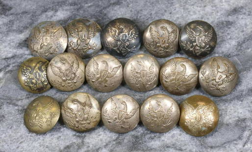
Sold2023Collection of Pre-Civil War US Army Eagle "A" Artillery ButtonsCollection of 16 pre-Civil War United States Army eagle "A" artillery coat buttons including: 1-piece buttons being Albert's GI79 with backmarks "A.W. SPIES/RICH"(1), "SCOVILLS/WATERBURY" (1), "PLATEDSee Sold Price
Sold2022AN AMERICAN CIVIL WAR ERA MAP, "United States of North America (Eastern & Central)," LONDON,AN AMERICAN CIVIL WAR ERA MAP, "United States of North America (Eastern & Central)," LONDON, 1861-1873, THEODORE ETTLING (b. 1823), hand colored lithograph on paper, by T. Ettling, published by CasselSee Sold Price
Sold20241835 United States Capped Bust Half DimeRare, pre Civil War era united states half dime or 5 cent silver coin. Shows wear but, a scarce coin, see photosSee Sold Price
Sold2019Colton's Civil War map of the United States 1862Heading: (Maps) Author: Colton, J.H. Title: Colton's United States Showing the Military Stations, Forts &c. Place Published: New York Publisher: Date Published: 1862 Description:See Sold Price
Sold2021Civil War Geographical Boundary mapDefinitive map of the geographical boundaries between the Union and Confederate armies. Opens a window into the state of the U. S. during the height of the Civil War. “Map of the United States oSee Sold Price
Sold202319C Antique 1855 Rockland Maine Early American MapAn antique American pre Civil War era map on paper. Printed 1855 by Wagner and McGuigan (Philadelphia), published by Edgar M. Woodford (1824-1862). Depicting the city of Rockland, Maine. Map shows theSee Sold Price
Sold2022Civil War Military map - scarce territorial bordersThe Johnson and Ward atlas company produced two memorable, double-page Civil War maps of the United States. This is the more desirable issue, showing the state and territory borders instead of the MilSee Sold Price
Sold2017Civil War Era Map of the United StatesUnited States. Taliaferro Preston Shaffner (1811 – 1881). Lithographed Map. London: Schaffner, 1862. 12 1/4 x 18 1/2 inchesSee Sold Price
Sold2017Civil War Era Map of the United StatesMap of the United States and Territories. Henry F. Walling (1825 - 1889) & Ormando W. Gray (fl. 1860 – 1880). Lithographed Map. Boston, 1871. 17 x 25 1/2 inches sheetSee Sold Price
Jun 08Early American History Auctions1863 JOHN ARCHIBALD CAMPBELL ALS Re: a Friends Prisoner Exchange Confederate Asst. Secretary of War$450
Jun 06Weatherham Estate TreasuresAbraham Lincoln Bronze Bust Sculpture On Marble Base - Signed Original - 10lbs$400
Jun 23Schilb Antiquarian Rare Books1860 Political Textbook 1ed SLAVERY Abe Lincoln Douglass Civil War Government$6(2 bids)
Jun 02Schilb Antiquarian Rare Books1874 Confederate 1ed General Joseph E Johnston Civil War Narrative CSA Military$22(3 bids)
Jun 23Schilb Antiquarian Rare Books1890 1ed Confederate Memoirs of Joseph Johnston & Jefferson Davis Civil War CSA$44(2 bids)
Jun 02Schilb Antiquarian Rare Books1885 1ed Ulysses S Grant Memorial + FAMILY PHOTO Julia Ward Howe America$28(5 bids)
Jun 15Bazaar of PersiaUS Half dollar 1922 100th anniversary Birth of Ulysses S. Grant Silver coin$400
4 days LeftWeatherham Estate TreasuresAbraham Lincoln Bronze Bust Sculpture On Marble Base - Signed Original - 10lbs$400
Jun 08Early American History AuctionsAbraham Lincoln 1864 Message from the President of the United States Ship Illegally Captured in 1862$150(1 bid)
Jun 08Early American History Auctions1865 Treasury Department Circular, Canal Boats Doing Business With Indian Tribes Are Exempt From Tax$220
Jun 23Schilb Antiquarian Rare Books1918 Robert E Lee Civil WAR Confederate General CSA Battles MAPS Illustrated$1(1 bid)
5 days LeftFreeman's | Hindman[CIVIL WAR] – [POLITICS]. A group of 18 CDVs of Union and Confederate personalities, incl.$250
Jun 02Schilb Antiquarian Rare Books1866 Women of the Civil War 1ed Americana Gettysburg Military Robert E Lee Moore$125(2 bids)
Jun 08Early American History AuctionsAbraham Lincoln Gettysburg Address on Muslin Cotton Fabric measuring 21.5 x 15.5$100
Jun 08Early American History Auctions1905 Civil War General OLIVER OTIS HOWARD Typed Letter Signed as President of the Lincoln Memorial$300
Jun 08Simpson Galleries, LLC.JULIUS BIEN (1826-1909) AN AMERICAN CIVIL WAR RECONNAISSANCE MAP, "Map of Texas and Part of New$100
5 days LeftFreeman's | Hindman[CIVIL WAR - FLAGS]. Paper flag promoting the Battle of Gettysburg Cyclorama in Baltimore, Maryland.$1,400(2 bids)
1 day LeftCol. Christie Hatman AuctioneersRARE 1881 THE RISE AND FALL OF THE CONFEDERATE GOVERNMENT JEFFERSON DAVIS TWO BOOK SET VINTAGE$5
Jun 08Early American History Auctions1862 Civil War Dated, Union General David Hunter Autograph Letter Signed Involving 3 Union Generals$600


![[CIVIL WAR] – [POLITICS]. A group of 18 CDVs of Union and Confederate personalities, incl. (1 of 4)](https://p1.liveauctioneers.com/197/329785/177758239_1_x.jpg?height=282&quality=70&version=1715625218)


![[CIVIL WAR - FLAGS]. Paper flag promoting the Battle of Gettysburg Cyclorama in Baltimore, Maryland. (1 of 3)](https://p1.liveauctioneers.com/197/329785/177758379_1_x.jpg?height=282&quality=70&version=1715625218)

