Sold2021San Diego with pictorial recreation map 1935Heading: (California - San Diego) Author: Title: Map of San Diego California City and County - with two maps, one a pictorial bird's-eye map Place Published: [San Diego] Publisher:Lowell E. Jones <See Sold Price
Sold2020Pictorial Map Southern CaliforniaRadio Comedians Map of Southern California. Radio Stations of Los Angeles and Orange County areas. 2nd Quarter, 20th Century. 11 1/2" x 18".See Sold Price
Sold2017Pictorial map of Southern CaliforniaHeading: (California) Author: Putnam, Claude G. Title: Southern California's Sunshine Empire and Golden Coast (wrapper title) Place Published: San Bernardino, CA Publisher:Southern California TouristSee Sold Price
Sold20201963 Putnam Pictorial Map of Southern California --Title/Content of Map: 1963 Putnam Pictorial Map of Southern California -- Ride the Roads to Romance along the Gold Coast thru the Sunshine Empire of Southern California Cartographer: C Putnam Year/PlaSee Sold Price
Sold20211950 Putnam Pictorial Map of Southern California --Title: 1950 Putnam Pictorial Map of Southern California -- Ride the Roads to Romance along the Gold Coast thru the Sunshine Empire of Southern California Cartographer: C Putnam Year / Place: 1950, SanSee Sold Price
Sold20211963 Putnam Pictorial Map of Southern California --Title: 1963 Putnam Pictorial Map of Southern California -- Ride the Roads to Romance along the Gold Coast thru the Sunshine Empire of Southern California Cartographer: C Putnam Year / Place: 1963, SanSee Sold Price
Sold2022BISHOP, Roy. Seattle. Bellevue: Bayside Publishing, 1976. C...BISHOP, Roy. Seattle. Bellevue: Bayside Publishing, 1976. Cartoonish pictorial bird’s-eye view map poster of Seattle. While the artist labels the city’s roads, bridges, and waterways, andSee Sold Price
Sold2017Putnam: Vintage Pictorial Map of South California, 1963Title/Content of Map: 1963 Putnam Pictorial Map of Southern California -- Ride the Roads to Romance along the Gold Coast thru the Sunshine Empire of Southern California Date Printed: 1963, San BernardSee Sold Price
Sold2023Pictorial bird's-eye map of Southern CaliforniaHeading: (California - Southern) Author: Putnam, Claude George, Sr. Title: Ride the Roads to Romance Along the Golden Coast and Thru the Sunshine Empire of Southern California Place Published: No placSee Sold Price
Sold2022California Pictorial MapFun Map of Southern California. All-Year Club, c. 1930s. Recreational activities. Santa Barbara, Malibu, Los Angeles, Santa Monica, San Diego. 11" x 11".See Sold Price
Sold2023Bethlehem pictorial bird's eye view city plan. Israel. #104. BOLLMANN 1970 mapTitle: Bethlehem pictorial bird's eye view city plan. Israel. #104. BOLLMANN 1970 map Description: Bethlehem' by Hermann Bollmann (1970). Vintage axonometric "bird's eye view" city tourist plan, 54.5See Sold Price
Sold2023Chicago. “City Character Print.” 1981. Toronto: Archar Inc....Chicago. “City Character Print.” 1981. Toronto: Archar Inc. Pictorial map with a bird’s-eye view of the city, initialed in plate to lower right, “R.V.N.” 13 5/8 x 18 3/8&See Sold Price
Sold2021EDDY, Gerald. Lake Tahoe / California-Nevada. Reno:EDDY, Gerald. Lake Tahoe / California-Nevada. Reno: Silver State Press, 1965. Offset lithograph birds-eye map of the area surrounding Lake Tahoe, looking east, showing Reno, Sparks, and Carson City, mSee Sold Price
Sold2023Antique 19th C. Map of East Los Angeles CountyAntique 19th Century panoramic map of East Los Angeles County, California, depicting a bird's-eye view from Los Angeles River looking towards the Sierra Madre Mountains. Printed by H.S. Crocker & Co.,See Sold Price
Sold20213 Pcs incl 1873 Birds Eye View of Highspire, PAPublished by JJ Stoner. Also includes souvenir semi-centenninal views of Scranton, PA with panoramic photo on verso and 1855 Philadelphia Map published by JH Colton for the Southern District of New YoSee Sold Price
Sold2023ASSORTED EUROPEAN / AFRICAN PICTORIAL MAPS, LOT OF TWOASSORTED EUROPEAN / AFRICAN PICTORIAL MAPS, LOT OF TWO, engraving on paper, comprising a bird's-eye view of the siege of the town Oost Ende (Ostend), a Flemish town, during The Eighty Years' WSee Sold Price
Sold2020Pan Pacific Exposition Birds-Eye View MapReproduction produced 1968 by First Savings and Loan Association from the original lithograph in the collection of the Society of California Pioneers. Color illustrated birds-eye view: "The ExpositionSee Sold Price
Sold2021Postcard Collection: Vintage Cards from AuburnLot of over 100 vintage postcards from Auburn California. Horse and buggy street scenes; Railroad Avenue; the Southern Pacific Depot; the iconic courthouse building; birds eye views.Date: Country (ifSee Sold Price
Sold2017Antique Birds Eye Map of the Mississippi Basin, 1866Title/Content of Map: Antique Birds Eye View of the Mississippi Basin Date Printed: 1866 Cartographer: Anonymous Size (inches): 9 x 14 Condition: Good. Slightly age toned as typical for paper of the eSee Sold Price
Sold2017J. J. Stoner, Birds-eye map of Helena, MontanaJ. J. Stoner, Birds-eye map of Helena, Montana, J.J. Stoner (American, 19th c.), "Bird's Eye View of Helena, 1883", illustrated and with index of points of interest, hand-colored engraving, publishedSee Sold Price
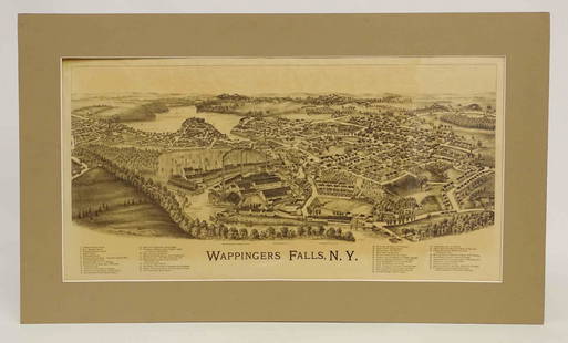
Sold2022Wappingers Falls New York Large ViewWappingers Falls, N.Y. Large Panorama Bird's-eye Map. L.R. Burleigh, Troy, New York, c. 1889. Antique print. 15" x 29".See Sold Price
Sold2015OLD MAP OF PARISA BIRD'S EYE MAP OF PARIS CITY FRINGED WITH THUMBNAILS OF THE TOP TOURIST SPOTS 28X38"See Sold Price
Sold2021(2) ANTIQUE GERMAN ETCHINGSIncluding a bird's eye map and aerial and profile views of German castle. Dimensions: (Larger frame) H 19" x W 23.5", (Sight) H 9.25" x W 13.5" Condition: Few signs of wear. One spot of discolorationSee Sold Price
Sold2020Road map of Southern California 1918Heading: (California) Author: Title: Automobile Road Map of Los Angeles, Orange, Riverside and San Bernardino Counties Place Published: Los Angeles Publisher:Security Trust & Savings Bank Date PSee Sold Price
3 days LeftPotter & Potter AuctionsPOLAND, Edwin Christian (1903 – 1991). The Evergreen Playgr...$200
3 days LeftPotter & Potter AuctionsLISTER, James Wren (1897 – 1952). Avalon Town / Santa Catal...$100(1 bid)
3 days LeftPotter & Potter Auctions[NEW YORK CITY – PICTORIAL MAPS]. Group of 3 pictorial maps...$200(1 bid)
3 days LeftPotter & Potter AuctionsBOLLMANN, Hermann (1911 – 1971). Map of New York City. 1962.$100
2 days LeftJasper52Bellin Map of St. Salvador, Brazil -- Plan de la ville de St. Salvador [with] Vue de la Ville de St.$55
3 days LeftPotter & Potter AuctionsPictorial Map of Hollywood and Vicinity / Hollywood Film Ca...$125(1 bid)
3 days LeftPotter & Potter AuctionsLINDGREN, Hjalmer “Jolly” (1895–1952). A Hysterical Map of ...$150(1 bid)
Jun 07Freeman's | Hindman[MORMONS]. MILLROY & HAYES (fl. 1899). Route of the Mormon Pioneers from Nauvoo to Great Salt Lake,$300
4 days LeftOakridge Auction GalleryA Chinese celadon and famille rose 'phoenix and birds' vase, early 19th century$100
2 days LeftJasper521614 Munster View of Utrecht Netherlands -- Von der Bischofflichen Statt Utrecht$70
3 days LeftPotter & Potter AuctionsHANDY, R.D. (1879 – 1959). Paul Bunyan’s Pictorial Map of t...$200(1 bid)
BonhamsHelen Rousseau (American, 1895-1992) Cultivation: Southern California 24 x 30 1/4in (61 x 76.5cm)$10
3 days LeftPotter & Potter AuctionsWalt Disney World EPCOT Center. 1982. Color pictorial map o...$125
3 days LeftPotter & Potter AuctionsCrosby Service Pictorial Map of Manhattan (New York City). ...$250


![San Diego with pictorial recreation map 1935: Heading: (California - San Diego) Author: Title: Map of San Diego California City and County - with two maps, one a pictorial bird's-eye map Place Published: [San Diego] Publisher:Lowell E. Jones <](https://p1.liveauctioneers.com/642/218849/112379283_1_x.jpg?height=310&quality=70&version=1631923877)


![[NEW YORK CITY – PICTORIAL MAPS]. Group of 3 pictorial maps... (1 of 3)](https://p1.liveauctioneers.com/928/325952/175495562_1_x.jpg?height=282&quality=70&version=1712935174)

![Bellin Map of St. Salvador, Brazil -- Plan de la ville de St. Salvador [with] Vue de la Ville de St. (1 of 1)](https://p1.liveauctioneers.com/5584/328338/176911634_1_x.jpg?height=282&quality=70&version=1715113718)


![[MORMONS]. MILLROY & HAYES (fl. 1899). Route of the Mormon Pioneers from Nauvoo to Great Salt Lake, (1 of 2)](https://p1.liveauctioneers.com/197/329395/177650560_1_x.jpg?height=282&quality=70&version=1715364962)


