Sold2017Reproduction Framed Historical Map of Darien CTFramed Historical Map of Darien, Connecticut. Measures 23 x 17 inches.See Sold Price
Sold20232 Framed Historical Maps, North America & Kentucky, Carey & Lea1st item: Geographical, Statistical & Historical map of North America, 1823, published by Henry Charles Carey (1793-1879) and Isaac Lea (1792-1886) Philadelphia, illustrated by J. Yeager. From A ComplSee Sold Price
Sold2020Kennel Club Framed RibbonsLot (2) vintage Kennel club framed ribbons. Darien Ct. and Berks County. Overall 28 1/4" x 8 1/2" and 36 1/4" x 8 1/2".See Sold Price
Sold2021Historical Map of Hartford, CT.Showing 17th and 18th c. landmarks, designed by James and Ruth Goldie, 1927, 17.5 x 24 inches.See Sold Price
Sold2020Burled Wood Framed Plan Map Stamford, Ct.Burled Wood Framed Plan Map Stamford, Ct. Professionally framed. 27 inches x 32 inches.See Sold Price
Sold20212 Framed Reproduction Historical Documents2 Framed reproduction historical documents, Declaration of Independence and Constitution, matted with inner bead gilt boarder and speckled black 23 3/8" x 25 3/8" frame. Condition; excellentSee Sold Price
Sold2021Framed Handkerchief Map of CTwith scenes from Kent Falls, Harkness Tower-Yale, & the State Capital-Hartford. Framed, not examined out of frame. Frame size: 18" high, 18" wide. Provenance: Property of a Fairfield County CT CollectSee Sold Price
Sold2021Framed Map Reproduction Print , Prospect of HarvardFramed Map Reproduction Print , Prospect of Harvard University and Radcliff College Cambridge Massachusetts , Measures about 26.5"x35" . Condition: Has a tear on the bottomSee Sold Price
Sold2022Framed Reproduction Map of Borough of Keyport 12x16Framed Reproduction Map of Borough of Keyport 12x16See Sold Price
Sold2022Map or Sharon Ct..Framed map of Sharon Ct.. Marked LRC "J.H. Campbell Lith. Rep. Millerton N.Y.". Sight 17 1/2" x 20 1/4", overall 22 1/4" x 25".See Sold Price
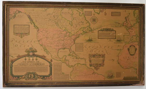
Sold2018Framed Map - Charles LindberghFramed reproduction map. Showing the Overland and Overseas Flights of Charles Lindbergh; 26.5in. X 46in.See Sold Price
Sold2023Framed Colored Print Of Historical Map Of Stuttgart In 1592-View After Jonathan SauterThis lot contains a framed colored print of a Historical Map Of Stuttgart In 1592-View After Jonathan Sauter. The print itself is approx 13 1/2" x 32" while the frame is approx 18 1/2" x 3See Sold Price
Sold2018Sky View Photograph Wee Burn Country ClubSky view photograph 1984 of Wee Burn Country Club Darien Ct, professionally framed and matted measures 22 by 26 inches, done by sky graphics, Wall art home decor accessory.See Sold Price
Sold2023New Haven Ct. Quadrangle Topographic Map FramedNew Haven Ct. Quadrangle Topographic Map Framed. 28 inchews x 22 inchesSee Sold Price
Sold2023FRAMED REPRODUCTION COLTON'S THE WORLD MAPFRAMED REPRODUCTION COLTON'S THE WORLD MAP Height: 44 in. by Width: 64 in.See Sold Price
Sold2019Two Framed Maps: Paris by J. Shury & HavanaA framed reproduction of an 1853 map of Havana [Framed dimensions: 17 1/4 x 21 3/4 inches], and a framed antique map of Paris, engraved by J. Shury. [Framed dimensions: 16 3/8 x 22 1/8 inches]. In gooSee Sold Price
Sold20223 Framed Vermont MapsA group of 3 framed Vermont maps including a reproduction 1796 Sotzmann 24" x 32" frame, Stowe Vermont from Beers Atlas 1878 19" x 23", and reproduction of Stowe Vermont map blown up, 25" x 32"See Sold Price
Sold2021Serge Nekrassoff Hammered Pewter Candlesticks c1920sSerge Nekrassoff - Darien, CT Hammered Pewter Candlesticks c1920s. Signed. Excellent condition. 5 7/8"d x 1.75"h. Spend $5000 or more at this auction and all of your SHIPPING IS FREE within the lowerSee Sold Price
Sold202318th C Antique Historical Map Of Montreal Quebec1758 Antique Historical Hand Tinted Map Of Montreal, Titled Plan of the Town and Fortifications of Montreal or Ville Marie in Canada. Map measures 7 inches H x 10 W within matting, framed 14.5 inchesSee Sold Price
Sold202319thC "Historical Map of Nantucket Surveyed and Drawn by The Rev. E.C. Ewer 1869" - overall framed19thC "Historical Map of Nantucket Surveyed and Drawn by The Rev. E.C. Ewer 1869" - overall framed size 10"x14"See Sold Price
Sold20222 PC. FRAMED EARLY MEDITERRANEAN MAPS2 PC. FRAMED EARLY MEDITERRANEAN MAPS: Comprising; 1- 1658 Jansson Map of the Indian Ocean. 1- This historical map illustrates the region involved in the conquest of Cyrus the Great (558-528 BC), theSee Sold Price
Sold2022Framed Map and Baltimore AdvocateTwo framed items to include a reproduction map of Anna Arundel Co. Together with an 1862 page from the Baltimore County Advocate. Mat opening of page: 20 in x 14 in. total.See Sold Price


![Two Framed Maps: Paris by J. Shury & Havana: A framed reproduction of an 1853 map of Havana [Framed dimensions: 17 1/4 x 21 3/4 inches], and a framed antique map of Paris, engraved by J. Shury. [Framed dimensions: 16 3/8 x 22 1/8 inches]. In goo](https://p1.liveauctioneers.com/1221/144060/73206131_1_x.jpg?height=310&quality=70&version=1562178741)


