Sold2021Scarce Civil War map showing entire ops of Army ofTitle: Scarce Civil War map showing entire ops of Army of Cumberland Description: Highly detailed, hard-to-find vintage map showing the entire scope of operations of the Army of the Cumberland duringSee Sold Price
Sold2021Scarce Civil War map - Union ops in Ky and Tenn., 1875Elusive map showing the armies of the Cumberland and Ohio’s operations in Kentucky and Tennessee in the Civil War. “No. 1 Map Exhibiting the Operations of the Armies of the Cumberland andSee Sold Price
Sold2021Scarce Civil War map showing Jeff Davis’ line ofTitle: Scarce Civil War map showing Jeff Davis’ line of flight, 1875 Description: "Elusive map showing the Union Army’s operations after Atlanta. “No. 16 Map Exhibiting the Operations ConductedSee Sold Price
Sold2022Scarce Civil War era map of Florida with great detail,Great map of Florida showing the entire state (includes small inset of Florida Keys). Shows state shortly after the outbreak of the Civil War. Notes proposed course of a canal route from Tampa to theSee Sold Price
Sold202221 Campaigns/Battles map - 1891 Civil War atlasLarge format layout of 21 Civil War maps on one sheet. (1-19) Campaign maps showing position of the 20th Army Corps on the march from Chattanooga, Tenn. to Atlanta, Ga. with dates and Union and RebelSee Sold Price
Sold2022Civil War Military map - scarce territorial bordersThe Johnson and Ward atlas company produced two memorable, double-page Civil War maps of the United States. This is the more desirable issue, showing the state and territory borders instead of the MilSee Sold Price
Sold2024Official Civil War Geographical Boundary map, Julius Bien 1891Scarce definitive map of the geographical boundaries between the Union and Confederate armies. Opens a window into the state of the U. S. during the height of the Civil War. “Map of the United SSee Sold Price
Sold2023Nice 1865 map of Florida from Johnson and WardJohnson’s Florida published in the last year of the Civil War and showing entire lower part of the state as undeveloped. Johnsons New Illustrated Family Atlas began its publishing history in 1860 anSee Sold Price
Sold2017Johnson: Antique 1st Edition Civil War Military Map1st edition Johnson’s Civil War Military Map, Johnson & Browning. Scarce 1861 map by A. J. Johnson showing the military deportment of the United States in 1860, just before war broke out in the statSee Sold Price
Sold2022Rare Seat of War 1862 Civil War pocket mapVery desirable and scarce large map of the Civil War issued during the early part of the war. Includes Virginia, Maryland and the Chesapeake Bay along with parts of other states. Depicts the entire EaSee Sold Price
Sold2019Scarce 1863 U. S. map w/Civil War ArizonaReserve Reduced! Map of the U. S. showing Arizona in the Civil War configuration designated in 1863. This lasted for only a short time so it’s possible that not very many of this edition were distriSee Sold Price
Sold2018Johnson & Ward: Kansas & Missouri, 1864The scarce and highly detailed map of the pivotal states of Missouri and Kansas near the end of the Civil War, with western Kansas still largely unorganized. In addition to showing major transcontinenSee Sold Price
Sold2017The Position of Yorktown and the ApproachesWashington Government Printing Office 1892. Civil War Map showing Union and Confederate troop locations and movement Size: 29 x 18 inches No Reserve: This lot starts at $1 and has no reserve as a courSee Sold Price
Sold2015Fisk & Russell Scarce Civil War Pocket MapThis circa 1862 hand colored folded pocket map was printed by Fisk & Russell, N.Y., no date or title but shows most of the U.S. and southern Canada with small inset map of ‘Eastern Part of MassaSee Sold Price
Sold2019United States. Civil war era military map. ShowingTitle/Content of Map: United States. Civil war era military map. Showing southern ports Date: 1863 Cartographer: By Johnson & Ward. From, Johnson’s New Illustrated Family Atlas Size: 18x 26 1/4”.See Sold Price
Sold2022Scarce Amer. Rev. War map showing Manhattan, Marshall/Yeager 1832Scarce Revolutionary War battle plan of the New York Campaign of 1776, from Marshall's Life of Washington. Shows the American positions on Manhattan Island. Covers the strategically important ManhattaSee Sold Price
Sold2019Alexandria, VA map by James TuthillScarce untitled Civil War era map of the area between Washington, D.C. and Mount Vernon by James Tuthill, lithographed by Herline and Hensel, Philadelphia, PA, published in Camden, NJ, circa 1861. IntSee Sold Price
Sold2024Civil War Map, Positions of the Army of the Ohio Front oh Dalton GA Dated 1864 34"L x 24"TCivil War Map, Positions of the Army of the Ohio Front oh Dalton GA Dated 1864 34"L x 24"TSee Sold Price
Sold2024Civil War Map, Positions of the 16th Army Corps Dated 1864 34"L x 24"TCivil War Map, Positions of the 16th Army Corps Dated 1864 34"L x 24"TSee Sold Price
Sold20191892 Cowles Civil War Map of Battles of the Army of theTitle/Content of Map: 1892 Cowles Civil War Map of Battles of the Army of the Cumberland in Kentucky, Virginia and Points South -- Map Prepared to Exhibit the Campaigns in which the Army of the CumberSee Sold Price
Sold2018Civil War Confederate Subsistence Department NoticeCivil War Late C.S.A. Subsistence Dept. Notice, 1p. Octavo., Richmond, Feb. 20, 1865. As food for the struggling Confederate Army becomes scarce, Commissary Gen. J. M. St. John advises all commissarySee Sold Price
Sold2021U. S. TERRITORY STILL UNDER INSURRECTIONARY CONTROLCivil War Dated Wood Engraved Map MAP SHOWING THE EXTENT OF UNITED STATES TERRITORY STILL UNDER INSURRECTIONARY CONTROL, Harper's Weekly, June 28, 1862 (Civil War, Confederate States, Rebels, SuccessiSee Sold Price
Sold20231899 1ed Life of Stonewall Jackson Campaigns Civil War Battles Confederate Maps1899 1ed Life of Stonewall Jackson Campaigns Civil War Battles Confederate Maps A scarce, childrens educational work by Mary L. Williamson on the life and military career of “Stonewall” JaSee Sold Price
Sold2018Archive of The Civil War. Map Volume Sommers, Richard JArchive of The Civil War. Map Volume. Sommers, Richard J. U.S. Army Military History Institute. First edition. All maps and materials present. Please note that this lot has a confidential reserve. WheSee Sold Price
Jun 22Lakeshore Event CenterEphemera, Civil War Generals, Abraham Lincoln, Ulysses Grant, Lot of 3$30(1 bid)
Jun 23Schilb Antiquarian Rare Books1890 1ed Confederate Memoirs of Joseph Johnston & Jefferson Davis Civil War CSA$66(3 bids)
Jun 26University ArchivesCapture of Jefferson Davis: “Mr. Davis tried to escape…with a ladies waterproof$1,600
Jun 23Schilb Antiquarian Rare Books1918 Robert E Lee Civil WAR Confederate General CSA Battles MAPS Illustrated$29(4 bids)
Jul 07Case Antiques, Inc. Auctions & Appraisals3 Civil War Era Photos, incl. Rose O'Neal Greenhow, poss. Jeff Davis$150
Jul 14Schilb Antiquarian Rare Books1928 Life of Abraham Lincoln 1ed SLAVERY Civil War Albert Beveridge 2v SET$1
Jul 04Weatherham Estate TreasuresAbraham Lincoln Bronze Bust Sculpture On Marble Base - Signed Original - 10lbs$400
Jul 06Case Antiques, Inc. Auctions & AppraisalsCivil War Veteran GAR Uniform, PVT Stephen F. Oliver$200(1 bid)
Jul 14Schilb Antiquarian Rare Books1885 Civil War 1ed Memoirs of Union General Ulysses S. Grant Illustrated MAPS 2v$48(4 bids)
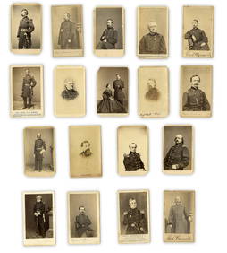
Jun 26University Archives18 pc. CDV Archive of Civil War Generals Incl. Many Brady & E. Anthony Examples$260(1 bid)
Jun 23Schilb Antiquarian Rare Books1860 Political Textbook 1ed SLAVERY Abe Lincoln Douglass Civil War Government$74(4 bids)
1 day LeftBazaar of PersiaUS Half dollar 1922 100th anniversary Birth of Ulysses S. Grant Silver coin$400
Jun 26University ArchivesIconic U.S. Grant Battlefield Albumen by Mathew Brady at City Point During Siege of Petersburg$400
Jun 28South Florida Auction & Estate Sale Services IncABRAHAM LINCOLN Memorial Belt Buckle Approved by MRS. LINCOLN$6(1 bid)