Sold2017Tobias Conrad Lotter Map of Germany, Vienna, 1760"Totius Germaiae Celeberrimae Viennae Austriacae" engraved and published by Tobias Conrad Lotter, Augsburg, 1760. Copper plate engraving with hand coloring of Germany and Austria with a city plan of VSee Sold Price
Sold2020Grp: 5 Maps of Germany Europe and the MediterraneGroup of five 18th century maps. This group includes a hand colored map of Germany by Herman Moll (ca. 1654-1732); one map of the Turkish empire by Tobias Conrad Lotter (1717-1777); one map of the BriSee Sold Price
Sold2022Lotter's Atlas Minor Containing 19-Hand-colored Engraved Maps & Title Page, C.1744Lotter, Tobias, Conrad, (Germany,1717-1777) & Seutter, Matthaus, (Germany,1678-1757) "Atlas Minor Pracipuaorbis Terrarum Imperia, Regna Et Provincias, Germania Potissimum, Tabelli 20. ExSee Sold Price
Sold2024Tobias Conrad Lotter Map Of Eastern Mediterranean & Middle EastMagni Turcarum Dominatoris Imperium per Europam, Asiam, et Africam, This striking map covers the Turkish Empire, extending to Greece, Arabia and Libya, with the Caspian and Black Seas and the easternSee Sold Price
Sold2019TOBIAS CONRAD LOTTER (German 1717-1777) A MAP,TOBIAS CONRAD LOTTER (German 1717-1777) A MAP, "SPATIOSISSIMUM IMPERIUM RUSSIAE MAGNAE JUXTA RECENTIFSIMAS OBFERVATIONES MAPPA GEOGRAPHICA..." "...accuratifsime delineatum opera et fumtibus Tobiae ConSee Sold Price
Sold2020Tobias Lotter Map of New England 1776Tobias Conrad Lotter (1717-1777), "A Map of the Most Inhabited part of New England, containing the Provinces of Massachusets Bay and New Hampshire, with the Colonies of Conecticut and Rhode Island, DiSee Sold Price
Sold2017Antique Map: New York & Area - EngravingPensylvania Nova Jersey et Nova York cum Regionibus Ad Fluvium Delaware In America Sitis, Nova Delinatione ob oculos posita...Tobias Conrad Lotter (1717 - 1777). Engraved map with hand-color in part.See Sold Price
SoldSEUTTER, MATTHÄUS. 1678-1757. And TOBIAS CONRAD LOTTER. 1717-1777. Recens edita totius Novi...SEUTTER, MATTHÄUS. 1678-1757. And TOBIAS CONRAD LOTTER. 1717-1777. Recens edita totius Novi Belgii in America Septentrionali. Augsburg: Tobias Conrad Lotter, 1757. Hand-colored engraved map, apprSee Sold Price
Sold2022SEUTTER FAMILY; engraved by TOBIAS CONRAD LOTTER. Group of 25 small-scale double-page engraved maps.SEUTTER FAMILY; engraved by TOBIAS CONRAD LOTTER. Group of 25 small-scale double-page engraved maps. 8¼x12½ inches each sheet size, wide margins; original hand-color in outline; mostly verySee Sold Price
Sold2022(MEDITERRANEAN.) Tobias Conrad Lotter. Carte Geographique Representant la Mer Mediterranee(MEDITERRANEAN.) Tobias Conrad Lotter. Carte Geographique Representant la Mer Mediterranee ou la Seconde Partie du Theatre de la Guerre Entre les Russes et les Turcs. Large engraved map of the MediterSee Sold Price
Sold2023FRAMED MAP Balearic Islands - “Carte des Isles de Maiorque, Minorque et D’Yvice†after TobiasFRAMED MAP Balearic Islands - “Carte des Isles de Maiorque, Minorque et D’Yvice” after Tobias Conrad Lotter, hand colored engraving, title cartouche, 19-1/2 x 22-1/2 inches framed CSee Sold Price
Sold2019Tobias Conrad Lotter (1717-1777, German), "MappaTobias Conrad Lotter (1717-1777, German), "Mappa Geographica Regionem Mexicanem et Floridam", 1740, hand colored, H. - 21 1/2 in., W. - 25 1/2 in.See Sold Price
Sold2019Tobias Conrad Lotter (1717-1777, German), "MappaTobias Conrad Lotter (1717-1777, German), "Mappa Geographica Regionem Mexicanem et Floridam," 1740, hand colored, H.- 21 1/2 in., W.- 25 1/2 in.See Sold Price
Sold2022(CONSTANTINOPLE.) Tobias Conrad Lotter. Plan von Constantinopel, mit der Umliegenden Gegend, und des(CONSTANTINOPLE.) Tobias Conrad Lotter. Plan von Constantinopel, mit der Umliegenden Gegend, und des Canals vom Schwarzen Meer. Double-page engraved plan of the Bosporus Strait with a panoramic perspeSee Sold Price
Sold2021TOBIAS LOTTER MAP OF BRITISH ISLESOriginal hand-colored engraving. 18th century. Three different hand-colored heraldic devices. Dimensions: (Frame) H 30.5" x W 26.5", (Sight) H 23.75" x W 20" Condition: Some light foxing. Unexamined oSee Sold Price
Sold2022Emanuel Eichel (1717-1782), After August SchellerEmanuel Eichel (1717-1782), After August Scheller Emanuel Eichel (1717-1782), After August Scheller 'Tobias Conrad Lotter, Statua Regum Europaeorum P.C.N. Nomina Continens' hand coloured copper engravSee Sold Price
Sold2019Tobias Lotter Antique Framed MapTobias Lotter antique map. Measures 7.75" x 10" plate size and approximately 8.5" x 11" sheet size. Good condition, taped to mat verso. We ship most items in this auction in house and gladly combine sSee Sold Price
Sold2023 [ATLASES]. LOTTER, Tobias Conrad (1717-1777) and Tobias LOB...[ATLASES]. LOTTER, Tobias Conrad (1717-1777) and Tobias LOBECK (1730-1763). Atlas Geographicus portatilis. [Augsburg: Johann Michael Wagner, ca. 1762]. Oblong 32mo. Engraved allegorical title-page andSee Sold Price
Sold2024Tobias Konrad Lotter & Matthäus Seutter - Map of ItalyCopper engraving, hand colored in outline and wash when published. Engraved by Tobias Konrad Lotter, Augsburg , 1756. Size: 27 cm x 21 cm.See Sold Price
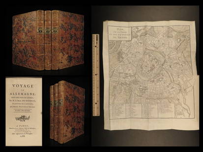
Sold20221788 Voyages Germany MAP Johann Riesbeck Letters Munich Vienna Austria 3v SET1788 Voyages Germany MAP Johann Riesbeck Letters Munich Vienna Austria 3v SET Johann Kaspar Riesbeck was a 18th-century German travel writer best-known for his book Letters from a French traveler in GSee Sold Price
Sold2023Smollett, Tobias 1761 Map. Seat of War, Empire of Germany"An Accurate Map of the seat of War in the Empire of Germany as also in the Kingdom of Prussia" Copper Engraved Map Published 1757-65, London for "A Complete History of England" by Tobias George SmollSee Sold Price
Sold2024Lotter Map Of Colonial North America In French By Matthew AlbertMap is roughly 1760's, Site 24.5" x 20.25"See Sold Price
Sold2017Lotter: Antique Map of Greece & Aegean Islands, 1770Map: Graecia Nova et Mare Aegeum Cartographer: Conrad Lotter Place & Date: Augsburg / 1770 (circa) Size: 22 3/4" x 19 3/4" Condition: repair at lower end of fold with minor loss at the bottom center bSee Sold Price
Sold2018Lotter: Antique Map of Africa, 1772Title/Content of Map: Africa by Lotter Date Printed: 1772 Cartographer: G.C. Lotter Material/Medium: Paper Size: 23" x 18" Hand colored copperplate engraved. Published in Augsburg Germany. Please noteSee Sold Price
Jun 08Potter & Potter Auctions[DÖBLER]. TITL, A. Emil (1809 – 82). Döbler’s Otische Nebel...$500
5 days LeftWhites Auctions CharlestonGerman Royal Vienna-Style Porcelain Urn/vase Signed Rinaldo and Armida$200
4 days LeftTrillium Antique Prints & Rare BooksDe Jode, Rare, pub. 1593 - Electors of the Holy Roman Empire (Ordines Sacri Romani Imp: Ab Ottone$100(1 bid)
22 hrs LeftKotler Galleries & AuctioneersROYAL VIENNA WAGNER VASE UNA GITANA ODALISQUE, GERMAN An outstanding Royal Vienna portrait$2,000
Jun 01Ripley AuctionsMaxim Bugzester, Polish (1910 - 1978), Expressionist landscape with house, oil on board, 16 1/4"H x$600(1 bid)
Jun 08Potter & Potter AuctionsBOSCO, Giovanni Bartolomeo (1793 – 1863). One-Page Bosco AL...$400
Jun 07Freeman's | Hindman[ENGLISH & CONTINENTAL MANUSCRIPTS]. A group of approximately 14 items, primarily autograph letters$400(1 bid)
6 hrs LeftJasper521788 Bowen Map of Ottoman Empire and Mediterranean Region -- A Correct Map of the Ottoman Empire,$140
Jun 02Taylor & HarrisContinental Vienna Style Porcelain Centerpiece Pedestal Bowl, Early 20th Century$1,000


![[ATLASES]. LOTTER, Tobias Conrad (1717-1777) and Tobias LOB...: [ATLASES]. LOTTER, Tobias Conrad (1717-1777) and Tobias LOBECK (1730-1763). Atlas Geographicus portatilis. [Augsburg: Johann Michael Wagner, ca. 1762]. Oblong 32mo. Engraved allegorical title-page and](https://p1.liveauctioneers.com/928/301544/160920949_1_x.jpg?height=310&quality=70&version=1694462960)


![[DÖBLER]. TITL, A. Emil (1809 – 82). Döbler’s Otische Nebel... (1 of 3)](https://p1.liveauctioneers.com/928/329228/177514516_1_x.jpg?height=282&quality=70&version=1715272280)


![[ENGLISH & CONTINENTAL MANUSCRIPTS]. A group of approximately 14 items, primarily autograph letters (1 of 1)](https://p1.liveauctioneers.com/197/329395/177650351_1_x.jpg?height=282&quality=70&version=1715364962)


