


Done
Chicago, IL, United States
Auction Details
Five Centuries of World Cartography
Hundreds of authentic, antique maps and prints offered by New World Cartographic.
Lot Number: Lowest
24
![A map of India, on the West Side of the Ganges,: [By Emmanuel Bowen, London, 1750]32.5 cm x 22.5 cm Laid paper. Title is framed by a rococo cartouche.Extends from Bombay across to the western part of the Godavari Delta and south to Cape Comorin](https://p1.liveauctioneers.com/6940/190006/95714319_1_x.jpg?height=310&quality=70&version=1609440753)
![Peninsula of India: Published by C. Smith, London, 180835.5 cm x 26.5 cm Original color (borders and margins only). Title is within a shaded box. Hills and towns shown, but no roads. (Plate 35 [from an atlas] noted in](https://p1.liveauctioneers.com/6940/190006/95714320_1_x.jpg?height=310&quality=70&version=1609440753)
![Suite de la Carte de l'Indoustan,: By Jacques-Nicolas Bellin, Paris, [ca. 1770] (Dutch edition)21.5 cm x 24 cm Original color. Title in decorative baroque cartouche. Watermarked paper. Shows coastal settlements, interior towns,](https://p1.liveauctioneers.com/6940/190006/95714321_1_x.jpg?height=310&quality=70&version=1609440753)
![Suite de la Carte de l'Indoustan,: [Possibly by Jacques-Nicolas Bellin, Paris, ca. 1770] 21.5 cm x 24.5 cm Notation in upper right indicates volume 4, page 408 (“Tom IV. Pag. 408”)Title in decorative baroque cartouche, with a](https://p1.liveauctioneers.com/6940/190006/95714322_1_x.jpg?height=310&quality=70&version=1609440753)

![The Southern Provinces of Hindoostan: By Robert Wilkinson, London, 1808[In Wilkinson’s General Atlas of the World, 2nd ed.]29.5 cm x 27.5 cm Original color, almost entirely faded (traces of green in Mahrattas territory, faint](https://p1.liveauctioneers.com/6940/190006/95714324_1_x.jpg?height=310&quality=70&version=1609440753)


![A Plan of Fort St. George and the City of Madras: [Labeled “V.I.” in upper left corner; “P 274” in upper right corner], [ca. 1720][Herman Moll]20 cm x 19 cm Watermarked paper (flower with leaf at the end of a second stem).](https://p1.liveauctioneers.com/6940/190006/95714327_1_x.jpg?height=310&quality=70&version=1609440753)
![Plan de Madras a la Coste de Coromandel: [By Jacques-Nicolas Bellin][Engraved by Croisey]Tome III. No. 37[In Petit Atlas Maritime, Paris, 1764]21.5 cm x 17.5 cm Watermarked paper. Title in cartouche at lower left, with scale in](https://p1.liveauctioneers.com/6940/190006/95714328_1_x.jpg?height=310&quality=70&version=1609440753)
![Plan de Madras et du Fort St Georges[,] Pris par les: [By Jacques-Nicolas Bellin, Paris, 1758]19 cm x 30.5 cm (40.5 cm with key)Watermarked paper (with design resembling a multipetaled flower, topped by an additional petal and with a fat, J-shaped](https://p1.liveauctioneers.com/6940/190006/95714329_1_x.jpg?height=310&quality=70&version=1609440753)


![Carte du District du Tranquebar: [By Jacques-Nicolas Bellin][In Antoine François Prévost’s Histoire générale des Voyages, ou nouvelle collection de toutes les relations de voyages par mer et par terre . . . , vol.](https://p1.liveauctioneers.com/6940/190006/95714332_1_x.jpg?height=310&quality=70&version=1609440753)


![Carte du Bengale et de ses dépendances: By William Bolts, [reengraving for French edition of original 1772 map; in Etat civil, politique et commercant de Bengale, tr. J.N. Demeunier, Maestricht, 1778]38 cm x 55 cm Watermarked](https://p1.liveauctioneers.com/6940/190006/95714337_1_x.jpg?height=310&quality=70&version=1609440753)
![Nouvelle Carte du Royaume de Bengale: By Jacques Nicolas Bellin, Paris, 1764[In Le Petit Atlas Maritime, vol. III]27.5 cm x 34.5 cm (H x W; all measurements are approximate)Original outline color (turquoise) to coast and](https://p1.liveauctioneers.com/6940/190006/95714338_1_x.jpg?height=310&quality=70&version=1609440753)

![Tabvla Asiae XI [map of Bengal and Burma, India]: [By Giordan Ziletti, Venice, 1574][In La Geographia di Claudio Tolomeo, published by Giralamo Ruscelli]17.5 cm x 23.5 cm Watermarked paper (with part of a symbol visible in lower right corner). On](https://p1.liveauctioneers.com/6940/190006/95714340_1_x.jpg?height=310&quality=70&version=1609440753)

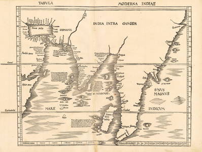
![India. (India intra Gangem): [By Sebastian Münster, Basel, 1576][From original map by Pomponius Mela in De Situ Orbis, based on Ptolemy’s Geographia from A.D. Second Century]12.5 cm x 15 cm Woodcut on watermarked paper](https://p1.liveauctioneers.com/6940/190006/95714342_1_x.jpg?height=310&quality=70&version=1609440753)
![Inde (under heading: La France): By A. Vuillemin, geographer; engraved by Ch. DyonnetPrinted by Imprimerie de Wittersheim, Paris, [ca. 1850]17.5 cm x 22.5 cm Original color (boundaries of British and subsidiary territories as well](https://p1.liveauctioneers.com/6940/190006/95714343_1_x.jpg?height=310&quality=70&version=1609440753)
View:
24
Auction Details

Bid Increments
PriceBid Increment
$0$10
$100$10
$200$20
$500$50
$1,000$100
$2,000$200
$5,000$500
$10,000$1,000
$20,000$2,000
$50,000$5,000
$100,000$500
$500,000$500
$1,000,000$500
$5,000,000$500
$10,000,000$1,000
$50,000,000$1,000
$100,000,000$5,000
$500,000,000$5,000
TOP