


Done
Chicago, IL, United States
Auction Details
Five Centuries of World Cartography
Hundreds of authentic, antique maps and prints offered by New World Cartographic.
Lot Number: Lowest
24

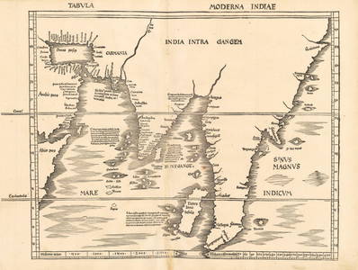
![Carte nouvelle des terres de Cucan, …: By Henri Abraham Chatelain, Amsterdam, [1720]38 cm x 43.5 cm Watermarked paper (shield with fleur de lis).Extends in the north from Goa across to the region around present-day Ongole, Andhra Pradesh,](https://p1.liveauctioneers.com/6940/190006/95714345_1_x.jpg?height=310&quality=70&version=1609440753)


![Hindoostan.: Engraver A. FindlayPublished by Thomas Kelly, London, [ca. 1828]24 cm x 18.5 cm Title is in shaded octagonal box. Major mountain ranges are indicated as well as rivers and towns, but no](https://p1.liveauctioneers.com/6940/190006/95714349_1_x.jpg?height=310&quality=70&version=1609440753)
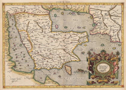
![Les Indes Orientales en-desa du Ganges[,] pour Servir: By Robert (Gilles Robert de Vaugondy), [Paris], 176237.5 cm x 30.5 cm Watermarked paper (“P PRAT[,] AGENOIS”). Clear, clean impression. Very attractive cartouche of baroque frame with](https://p1.liveauctioneers.com/6940/190006/95714350_1_x.jpg?height=310&quality=70&version=1609440753)
![Presqv l'Isle de l'Inde desa la Gange, ou sont les: [By Adriaan/Antoine de Winter, Paris, ca. 1683/1700]19 cm x 24.5 cm Watermarked paper (with symbol difficult to decipher). Modern color. Title cartouche on lower left is framed by two palm branches](https://p1.liveauctioneers.com/6940/190006/95714351_1_x.jpg?height=310&quality=70&version=1609440753)


![Hondius his Map of China: [By Jodocus Hondius (Joost de Hondt)][In Purchas His Pilgrimes in Five Bookes, Book 4, 437861][Printed by William Stansby for Henrie Fetherstone, London, 1625]14.5 cm x 18.5 cm Watermarked paper.](https://p1.liveauctioneers.com/6940/190006/95714359_1_x.jpg?height=310&quality=70&version=1609442280)

![Asiae Recentiaima Delineatio, qua Status et Imperia: By Johann Baptist Homann[In Atlas Novus Terrarum Orbis Imperia, Regna et Status Exactis Tabulis Geographice Demonstrans][Nürnberg, ca. 1720]49 cm x 57.5 cm Some offsetting and loss of original](https://p1.liveauctioneers.com/6940/190006/95714361_1_x.jpg?height=310&quality=70&version=1611162103)
![Chine et Indes avec les Iles; D'apr's les: By Louis Brion de la Tour[In Atlas Genéral, plate 43], Paris, 176623 cm x 26 cm (with attached text: 23 cm x 48 cm)Watermarked paper (with a circle within which is a cross above the letters HIS).](https://p1.liveauctioneers.com/6940/190006/95714362_1_x.jpg?height=310&quality=70&version=1609440753)

![India Orientalis: [By Gerard Mercator; engraved by Pieter van den Keere][Italian edition][Published by Johannes Cloppenburgh, Amsterdam, 1632; p. 205]19 cm x 25.5 cm Watermarked paper. Attractive modern coloring.](https://p1.liveauctioneers.com/6940/190006/95714364_1_x.jpg?height=310&quality=70&version=1609440753)
![Indiae Orientalis et insularum Adiacentium[,] Antiqua: [By Philipp Cluver (Cluverius)][In Introductionis in Universam Geographicam, No. 32, Amsterdam, 1697 (1667?)]21.5 cm x 26 cm Watermarked paper (with symbol of what appears to be an elaborate crest).](https://p1.liveauctioneers.com/6940/190006/95714365_1_x.jpg?height=310&quality=70&version=1609440753)
![1655 [Indians Hunting Stags.]: By: Theodor de Bry / Johann Ludwig GottfriedDate: 1655 (Published) FrankfurtDimensions: 6 x 8.5 inches (15.24 cm x 20.32 cm)This engraving depicts indigenous peoples of North America as they hunt](https://p1.liveauctioneers.com/6940/190006/95714366_1_x.jpg?height=310&quality=70&version=1609440753)

View:
24
Auction Details

Bid Increments
PriceBid Increment
$0$10
$100$10
$200$20
$500$50
$1,000$100
$2,000$200
$5,000$500
$10,000$1,000
$20,000$2,000
$50,000$5,000
$100,000$500
$500,000$500
$1,000,000$500
$5,000,000$500
$10,000,000$1,000
$50,000,000$1,000
$100,000,000$5,000
$500,000,000$5,000
TOP