


Done
New York, NY, United States
Auction Details
16th-20th Century Antiquarian Maps
Explore both land and sea with this array of maps, which preserves the geography of nearly every region imaginable. Unlike modern maps, these original engravings trace borders as they evolved throughout history. Discover centuries-old views of every corner of America or a map of Portugal and parts of Spain from 1645! Not only will these maps serve as decorative pieces, but they also will reveal innumerable ways to view our world.
Lot Number: Lowest
24
Sold
0001: 1730 (mid 1800s) Seutter World Map -- Diversi Globi Terr-Aquei Statione Variante et VisuEst. $1,100-$1,500
See Sold Price

0002: Denoyer-Geppert Relief-Like Series. Union of Soviet Socialist Republics and Adjacent LandsEst. $200-$250Lot Passed
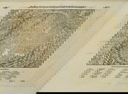
![1640 c. Blaeu Map of Northeast Italy Centered on Urbino -- Ducato di Urbino: Title: 1640 c. Blaeu Map of Northeast Italy Centered on Urbino -- Ducato di UrbinoCartographer: Blaeu [family]Year / Place: 1640 c., AmsterdamMap Dimension (in.): 15 X 19.6 in. This is a lovely](https://p1.liveauctioneers.com/5584/305309/163064925_1_x.jpg?height=310&quality=70&version=1697577828)
0003: 1640 c. Blaeu Map of Northeast Italy Centered on Urbino -- Ducato di UrbinoEst. $350-$400Lot Passed

0004: The Netherlands Map. The region Around the city of Utrecht. 1660’s by W. BlaeuEst. $150-$200Lot Passed

0005: 1922 Photomap Co Aerial Map of Pasadena -- Aerial Photomap of PasadenaEst. $300-$350Lot Passed


0007: 1775 d'Apres de Mannevillette Map of South African Coast -- Carte Reduite de la Cote MeridionaleEst. $300-$350Lot Passed

Sold
0009: 1745 De L'Isle Map of Scandinavia and the Baltics -- Carte des Courones du Nord Dediee au TresEst. $200-$250
See Sold Price


0012: Map of the Railroads in Whole Or in Part West, North Or South of the Missouri River,Est. $200-$250Lot Passed


0015: 1798 La Perouse Map of the Samoan Islands -- Chart of the Archipelago of Navigators…Est. $150-$200Lot Passed


View:
24
Auction Details

Bid Increments
PriceBid Increment
$0$1
$10$5
$100$10
$200$20
$500$50
$1,000$100
$2,000$200
$5,000$500
$10,000$1,000
$20,000$2,000
TOP