


Done
New York, NY, United States
Auction Details
16th-20th Century Antiquarian Maps
Explore both land and sea with this array of maps, which preserves the geography of nearly every region imaginable. Unlike modern maps, these original engravings trace borders as they evolved throughout history. Discover centuries-old views of every corner of America or a map of Portugal and parts of Spain from 1645! Not only will these maps serve as decorative pieces, but they also will reveal innumerable ways to view our world.
Lot Number: Lowest
24

0049: Kansas, Nebraska, Colorado, Dakota, Wyoming and Part of Montana, With Manitoba | Iowa & MissouriEst. $50-$60Lot Passed

Sold![1869 Mitchell Map of US Midwest -- XIV Ohio, Kentucky, Indiana, Illinois, Iowa and Missouri [verso]: Title: 1869 Mitchell Map of US Midwest -- XIV Ohio, Kentucky, Indiana, Illinois, Iowa and Missouri [verso] XV Michigan and WisconsinCartographer: S MithchellYear / Place: 1869, PhiladelphiaMap](https://p1.liveauctioneers.com/5584/305309/163064973_1_x.jpg?height=310&quality=70&version=1697577828)
0051: 1869 Mitchell Map of US Midwest -- XIV Ohio, Kentucky, Indiana, Illinois, Iowa and Missouri [verso]Est. $60-$70
See Sold Price

Sold
0053: 1858 Mitchell Map of New York to North Carolina -- No. 11 Map of the Middle States and Part of theEst. $40-$50
See Sold Price

0054: 1744 Senex Map of Africa -- Africa According to the Latest ObservationsEst. $100-$120Lot Passed


Sold
0057: 1830 US Government Map of US Population Distribution -- Distribution of the Population East of theEst. $80-$100
See Sold Price
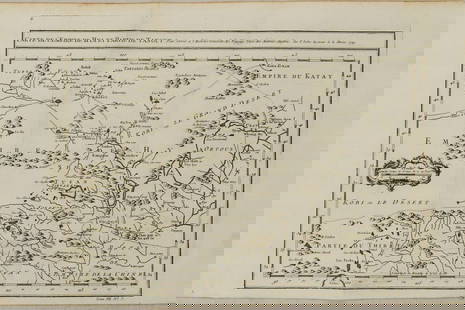
0058: 1749 Bellin Map of Inner China -- Carte de l'Empire de Hya et Partie de TangutEst. $120-$150Lot Passed


0063: Map of preliminary survey of Mississippi River between station 1840 of the Warsaw-Quincy SurveyEst. $30-$40Lot Passed


0066: 1944 Lowell Thomas' War Map of the World -- Lowell Thomas' War Map of the WorldEst. $50-$60Lot Passed


![1890 c. Cram Map of Austria-Hungary [verso] Germany -- Austria [verso] Germany: Title: 1890 c. Cram Map of Austria-Hungary [verso] Germany -- Austria [verso] GermanyCartographer: G CramYear / Place: 1890 c., ChicagoMap Dimension (in.): 8.2 X 11.2 in. This is a nice map of](https://p1.liveauctioneers.com/5584/305309/163064992_1_x.jpg?height=310&quality=70&version=1697577828)
0070: 1890 c. Cram Map of Austria-Hungary [verso] Germany -- Austria [verso] GermanyEst. $40-$50Lot Passed

Sold
0072: 1858 Mitchell Map of Mexico, the Caribbean and Central America -- No. 16 Map of Mexico, CentralEst. $50-$60
See Sold Price

View:
24
Auction Details

Bid Increments
PriceBid Increment
$0$1
$10$5
$100$10
$200$20
$500$50
$1,000$100
$2,000$200
$5,000$500
$10,000$1,000
$20,000$2,000
TOP