


Three 18th Century North Carolina Maps
Similar Sale History
View More Items in Maps & Atlases


Related Maps & Atlases


![[PICTORIAL MAPS – TRAVEL]. Three Pictorial Maps. 1940s/50s....: [PICTORIAL MAPS – TRAVEL]. Three Pictorial Maps. 1940s/50s. Three brochure sized foldout maps designed for travel including: Highroads to Happiness. Mexico City: Pemex Travel Club, ca. 1940s. &#](https://p1.liveauctioneers.com/928/325952/175495561_1_x.jpg?height=310&quality=70&version=1712935174)


![Descrittione dell' Isola di Cuba. PORCACCHI. Jamaica Hispaniola 1590 old map: CAPTION PRINTED BELOW PICTURE: Descrittione dell' Isola di Cuba [Description of the island of Cuba] The map depicts the Caribbean island of Cuba. The map is orientated towards the north. DATE PRINTED:](https://p1.liveauctioneers.com/5584/327764/176590845_1_x.jpg?height=310&quality=70&version=1714507756)
![Descrittione dell' Isola di Cuba. PORCACCHI. Jamaica Hispaniola 1620 old map: TITLE/CONTENT OF MAP: Descrittione dell' Isola di Cuba [Description of the island of Cuba] The map depicts the Caribbean island of Cuba. The map is orientated towards the north. DATE PRINTED: 1620 IMA](https://p1.liveauctioneers.com/5584/327764/176591154_1_x.jpg?height=310&quality=70&version=1714507756)


![Descrittione dell' Isola Iamaica…. PORCACCHI. Jamaica 1590 old antique map: CAPTION PRINTED BELOW PICTURE: Descrittione dell' Isola Iamaica, hora detta si S. Iacopo [Description of the island of Jamaica, now called St. Jacob's island] The map depicts the Caribbean island of J](https://p1.liveauctioneers.com/5584/327764/176591064_1_x.jpg?height=310&quality=70&version=1714507756)


More Items in Maps & Atlases
View More


![[Maps] Gio. Ant. Magnini, Italia, 1620: [Maps] Gio. Ant. Magnini, Italia, 1620, Giovanni Antonio Magnini. Italia, data in luce da Fabio suo figliuolo al Serenissimo Ferdinado Gonzaga Duca di Matoua edi Monserrato etc. Bologna, for Sebastian](https://p1.liveauctioneers.com/188/326797/176317457_1_x.jpg?height=310&quality=70&version=1713847031)


Recommended Transportation & Travel Collectibles
View More


Item Details
Description
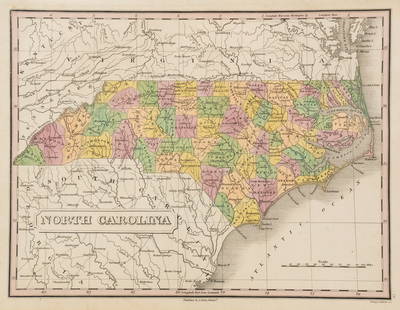
engravings on laid paper, all unframed, including: John Reid, The State of North Carolina From the Best Authorities, engraver Benjamin Tanner, New York, circa 1796, sheet 16-1/2 x 19 in.; Matthew Carey, North Carolina, engraver William Barker, from Carey's American Pocket Atlas, circa 1796-1801, 6-1/2 x 8-1/2 in.; North Carolina, marked "Lon. W. from Philadelphia", 6-3/4 x 8-1/4 in.
Provenance: Humber Family, North Carolina
Condition
all with some light toning, especially at edges, some light wear to edges; Reid formerly hinged in, remnants of tape at top
Buyer's Premium
- 28%
Three 18th Century North Carolina Maps
Estimate $500 - $700
14 bidders are watching this item.
Shipping & Pickup Options
Item located in Asheville, NC, usOffers In-House Shipping
Local Pickup Available
Payment

TOP