


1758 but 1850 Pease Map Near Rome, New York -- Topographical map of the Country between the Mohawk
Similar Sale History
View More Items in Maps & Atlases


![Sketch of the Country...Long Island.: [Map/New York] Sketch of the Country Illustrating the Late Engagement in Long Island, from The Gentleman's Magazine, London, 1776. Handcolored copperplate engraving. Published in October 1776, of this](https://p1.liveauctioneers.com/179/305680/163721131_1_x.jpg?height=310&quality=70&version=1697214016)


Related Maps & Atlases
![Sanitary & Topographical "Viele Map" of Manhattan 1865 [182838]: Manhattan Island map surveyed by Mexican American & Civil War veteran Egbert Viele 1865. Viele was author of a color city map, a "Sanitary & Topographical Map of the City and Island of New York," firs](https://p1.liveauctioneers.com/2699/331495/178785766_1_x.jpg?height=310&quality=70&version=1717094933)


![Map of Oceania, Australia, c1857 [180167]: Map of Oceania designed to accompany Cornell's High School Geography, Published by New York D. Appleton & Co. C. 1857. Victoria, Australia is highlighted in red. Around the time this map was made, the](https://p1.liveauctioneers.com/2699/331495/178785783_1_x.jpg?height=310&quality=70&version=1717094933)
![Maps of Europe, c1800's (4) [180165]: (4) Maps of Europe from atlas. 1. Map of Europe, borders colored in purple, legend includes railways, submarine telegraphs, boundaries of countries, capitals. Images of ships indicate oceans. 27.5 x 1](https://p1.liveauctioneers.com/2699/331495/178785788_1_x.jpg?height=310&quality=70&version=1717094933)


![1902 Cram Map of New York City [verso] Washington DC [verso] Baltimore -- New York [verso]: Title: 1902 Cram Map of New York City [verso] Washington DC [verso] Baltimore -- New York [verso] Washington] and [verso] Baltimore Cartographer: G Cram Year / Place: 1902, Chicago Map Dimension (in.)](https://p1.liveauctioneers.com/5584/331064/178466310_1_x.jpg?height=310&quality=70&version=1716924723)


![Map of Southeastern New York.: Publication Date: 1884 Title: Map of Southeastern New York. Cartographer: [RAND, MCNALLY & CO.] Publisher: H.H. HARDESTY & CO. Height: 19.5 Width: 13.3 Double-page map from a scarce Hardesty atlas. In](https://p1.liveauctioneers.com/5584/331064/178466313_1_x.jpg?height=310&quality=70&version=1716924723)
![Map of Western New York.: Publication Date: 1884 Title: Map of Western New York. Cartographer: [RAND, MCNALLY & CO.] Publisher: H.H. HARDESTY & CO. Height: 12.75 Width: 20 Double-page map from a scarce Hardesty atlas. Letterpr](https://p1.liveauctioneers.com/5584/331064/178466481_1_x.jpg?height=310&quality=70&version=1716924723)


![Jay Van Everen NY Caricature Map c1923 [181039]: This 11" x 34" map is titled "Nicholas. His Map" - a caricature map, c1923, of New York, drawn by Jay Van Everen for the book, "Nicholas" a Manhattan Christmas story by Anne Carroll Moore, and illustr](https://p1.liveauctioneers.com/2699/331495/178785764_1_x.jpg?height=310&quality=70&version=1717094933)

More Items in Maps & Atlases
View More![[MAP]. TODESCHI, Pietro. [Nova et Acurata Totius Americae Tabula auct. G.I. Blaeu] America quarta: [MAP]. TODESCHI, Pietro. [Nova et Acurata Totius Americae Tabula auct. G.I. Blaeu] America quarta pars orbis quam plerunq, nuvum orbem appellitant primo detecta est anno 1492 a Christophoro Columbo...](https://p1.liveauctioneers.com/197/329395/177650542_1_x.jpg?height=310&quality=70&version=1715364962)
![[MAPS]. HOMANN, Johann Baptist, HOMANN HEIRS, and Georg Matthäus SEUTTER. [Composite Atlas].: [MAPS]. HOMANN, Johann Baptist (1663-1724), HOMANN HEIRS, and Georg Matthäus SEUTTER (1678-1757). [Composite Atlas]. [Nuremberg, Augsburg, and others: Homann Heirs and others, maps dated between](https://p1.liveauctioneers.com/197/329395/177650530_1_x.jpg?height=310&quality=70&version=1715364962)


![[MAP]. ORTELIUS, Abraham. Americae Sive Novi Orbis, Nova Descriptio. 1573.: [MAP]. ORTELIUS, Abraham (1527-1598). Americae Sive Novi Orbis, Nova Descriptio. Antwerp, 1573. Engraved map with hand-coloring. Framed and double glazed, visible area 375 x 521 mm (unexamined out of](https://p1.liveauctioneers.com/197/329395/177650534_1_x.jpg?height=310&quality=70&version=1715364962)

![Set of Twelve Satirical Anthropomorphic Maps of Europe: [SATIRICAL MAPS] A set of twelve satirical anthropomorphic maps of Europe. London: circa 1868. A set of 12 (believed complete) lithographed maps by Vincent Brooks, Day & Son, London, each offering](https://p1.liveauctioneers.com/292/330597/178279264_1_x.jpg?height=310&quality=70&version=1716409282)


![[MAP]. ORTELIUS, Abraham. Turcici Imperii Descriptio.1592.: [MAP]. ORTELIUS, Abraham (1527-1598). Turcici Imperii Descriptio. Antwerp, 1592. Engraved map with hand-coloring. Matted, framed, and double glazed, sight 406 x 521 mm (unexamined out of frame). Decor](https://p1.liveauctioneers.com/197/329395/177650538_1_x.jpg?height=310&quality=70&version=1715364962)
![[MAP]. ORTELIUS, Abraham. Romani Imperii Imago. 1592.: [MAP]. ORTELIUS, Abraham (1527-1598). Romani Imperii Imago. Antwerp, 1592. Engraved map with hand-coloring. Matted, framed, and double glazed, visible area 381 x 521 mm (unexamined out of frame). 6 de](https://p1.liveauctioneers.com/197/329395/177650537_1_x.jpg?height=310&quality=70&version=1715364962)
![[MAP]. SPEED, John. A New Mappe of the Romane Empire. 1676.: [MAP]. SPEED, John (ca 1551-1629). A New Mappe of the Romane Empire. London: Basset & Chiswell, 1676. Engraved map with hand-coloring. Framed and double glazed, sight 419 x 559 mm. Decorative cartouch](https://p1.liveauctioneers.com/197/329395/177650541_1_x.jpg?height=310&quality=70&version=1715364962)

![[MAP]. ORTELIUS, Abraham. Aevi Veteris, Typus Geographicus. 1601.: [MAP]. ORTELIUS, Abraham (1527-1598). Aevi Veteris, Typus Geographicus. Antwerp, 1601. Engraved map with hand-coloring. Matted, framed, and double glazed, visible area 343 x 470 mm (unexamined out of](https://p1.liveauctioneers.com/197/329395/177650532_1_x.jpg?height=310&quality=70&version=1715364962)
Recommended Transportation & Travel Collectibles
View More


Item Details
Description
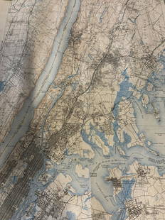
The is a very detailed, lithographed map of the area near today's Rome, New York from the mid 18th century. Forts Newport, Craven, Williams and Stanwix are shown. They guarded an important portage between the Mohawk River and Wood Creek, known as the Oneida Carry, along the important trade route between Albany and Lake Ontario. This area was the site of several important battles during the French and Indian War. Fort Stanwix, built by the British in 1758, was later occupied by the Continental Army during the American Revolutionary War. All original examples are rare. This example was made by R. H. Pease in Albany in 1852, who based it on Jefferys' plan in pocession of the New York State Library.
Reserve: $100.00
Shipping:
Your purchase is protected:
Photos, descriptions, and estimates were prepared with the utmost care by a fully certified expert and appraiser. All items in this sale are guaranteed authentic.
In the rare event that the item did not conform to the lot description in the sale, Jasper52 specialists are here to help. Buyers may return the item for a full refund provided you notify Jasper52 within 5 days of receiving the item.
Condition
Fair - Good. Slight toning. Issued folds with multiple splits, some closed on verso. Chips at edges. Uncolored.
Buyer's Premium
- 15%
1758 but 1850 Pease Map Near Rome, New York -- Topographical map of the Country between the Mohawk
Estimate $120 - $150
2 bidders are watching this item.
Get approved to bid.
Shipping & Pickup Options
Item located in Ohio, US$17 shipping in the US
Payment
Accepts seamless payments through LiveAuctioneers
See More Items From This Jasper52 Seller

TOP