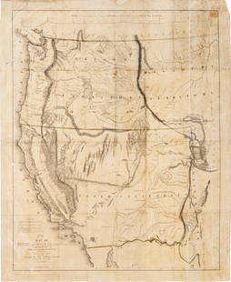
Preuss map Oregon Road in 7 sheets 1849
Similar Sale History
View More Items in Maps & AtlasesRelated Maps & Atlases
More Items in Maps & Atlases
View MoreRecommended Transportation & Travel Collectibles
View More


Item Details
Description
Author: Preuss, Charles
Title: Topographical Map of the Road from Missouri to Oregon, Commencing at the Mouth of the Kansas in the Missouri River and Ending at the Mouth of the Wallah Wallah in the Columbia, In VII Sections.... From the field notes and journal Capt. J.C. Frémont, and from sketches and notes made on the ground by his assistant Charles Preuss
Place Published: Washington
Publisher:
Date Published: 1846-[1849]
Description:
Lithographed map on 7 sheets. Each sheet approx. 39.5x63.5 cm (15¾x25"), folding into later cloth-backed boards 21.5x13 cm (8½x5¼").
Preuss's landmark map, based on the great Frémont/Preuss map of 1845 but in much more detail over the area depicted, in response to a request by the Senate of the United States, under whose auspices it was published. This is the second issue, or edition, published three years after the separately issued first edition, in John A. Rockwell's "Report... survey of certain routes for a canal or railroad between the Atlantic and Pacific Oceans; also... the establishment of a national road from the western frontier of Arkansas to California..." This version of the map is identical to that of the original 1846 Senate issue, except that the it does not have the Baltimore lithographer's name (E. Weber), and Sheet VI was misnumbered. Wheat remarks that the finished map "was a road guide for Oregon emigrants such as had never previously existed... The purview of each section is quite narrowly limited to the emigrant road, but the topography is developed in rather more detail than on the parent map. Owing to its rarity and to its having long stood in the shadow of the much more widely known and distributed Frémont map of 1845, Preuss's sectional map of 1846 has been insufficiently appreciated by students of Western history...." There are tables of meteorological observations and descriptive commentary on the map. Wheat illustrates all seven sections of the map. Graff 3360; Streeter Sale 3100; Wagner-Camp 115 (note); Wheat Transmississippi 523 (all referring to 1846 issue of the map).
Condition
Buyer's Premium
- 30%
Preuss map Oregon Road in 7 sheets 1849
Shipping & Pickup Options
Item located in Berkeley, CA, usPayment


![1866 Johnson Map of Washington, Oregon Minnesota -- Johnson's Oregon and Washington [on sheet with]: Title: 1866 Johnson Map of Washington, Oregon Minnesota -- Johnson's Oregon and Washington [on sheet with] Johnson's Minnesota Cartographer: Johnson & Ward Year / Place: 1866, New York Map Dimension (](https://p1.liveauctioneers.com/5584/300803/160206896_1_x.jpg?height=310&quality=70&version=1693946338)


![MAP - Venezuela. Laurie & Whittle: Venezuela. Laurie & Whittle, Plan of the Road and Town of La Guayra on the Coast of Caraccas, by an Officer in Admiral Knowles's Squadron [on sheet with] Plan of Puerto Cavello, on the Coast of the Ca](https://p1.liveauctioneers.com/6576/136723/69438010_1_x.jpg?height=310&quality=70&version=1550846033)
![(AMERICAN SOUTH.) Abraham Bradley. [Sheet 3, from]: Map of the United States Exhibiting the: (AMERICAN SOUTH.) Abraham Bradley. [Sheet 3, from]: Map of the United States Exhibiting the Post-Roads, the Situations, Connexions & Distances of the Post-Offices Stage Roads, Counties, & Principal Ri](https://p1.liveauctioneers.com/199/251723/130782249_1_x.jpg?height=310&quality=70&version=1655133895)


![Pocket Map of Richland Co., OH c1910 [180795]: Pocket map - "New Road Map of Richland County, Ohio." Published by The Daily Globe, Shelby, OH, c1910. Map measures 21" x 30". Please see photo(s) for more details. Richland County Ohio](https://p1.liveauctioneers.com/2699/331495/178785767_1_x.jpg?height=310&quality=70&version=1717094933)


![De Bry & Vopel Map of the Rhine River: DE BRY, Theodor de (1528-1598) after Caspar Vopel (1511–1561). [Rhine River Map] Rheni Tricornis et Vvidi Nova et Germana Descriptio, Additis Fluminibus... Engraved map. Frankfurt: T. de Bry, 1594.](https://p1.liveauctioneers.com/1968/330639/178336641_1_x.jpg?height=310&quality=70&version=1716827770)


![[MAPS]. HOMANN, Johann Baptist, HOMANN HEIRS, and Georg Matthäus SEUTTER. [Composite Atlas].: [MAPS]. HOMANN, Johann Baptist (1663-1724), HOMANN HEIRS, and Georg Matthäus SEUTTER (1678-1757). [Composite Atlas]. [Nuremberg, Augsburg, and others: Homann Heirs and others, maps dated between](https://p1.liveauctioneers.com/197/329395/177650530_1_x.jpg?height=310&quality=70&version=1715364962)
![[MAP]. TODESCHI, Pietro. [Nova et Acurata Totius Americae Tabula auct. G.I. Blaeu] America quarta: [MAP]. TODESCHI, Pietro. [Nova et Acurata Totius Americae Tabula auct. G.I. Blaeu] America quarta pars orbis quam plerunq, nuvum orbem appellitant primo detecta est anno 1492 a Christophoro Columbo...](https://p1.liveauctioneers.com/197/329395/177650542_1_x.jpg?height=310&quality=70&version=1715364962)

![[MAP]. ORTELIUS, Abraham. Americae Sive Novi Orbis, Nova Descriptio. 1573.: [MAP]. ORTELIUS, Abraham (1527-1598). Americae Sive Novi Orbis, Nova Descriptio. Antwerp, 1573. Engraved map with hand-coloring. Framed and double glazed, visible area 375 x 521 mm (unexamined out of](https://p1.liveauctioneers.com/197/329395/177650534_1_x.jpg?height=310&quality=70&version=1715364962)


![Set of Twelve Satirical Anthropomorphic Maps of Europe: [SATIRICAL MAPS] A set of twelve satirical anthropomorphic maps of Europe. London: circa 1868. A set of 12 (believed complete) lithographed maps by Vincent Brooks, Day & Son, London, each offering](https://p1.liveauctioneers.com/292/330597/178279264_1_x.jpg?height=310&quality=70&version=1716409282)


![[MAP]. ORTELIUS, Abraham. Turcici Imperii Descriptio.1592.: [MAP]. ORTELIUS, Abraham (1527-1598). Turcici Imperii Descriptio. Antwerp, 1592. Engraved map with hand-coloring. Matted, framed, and double glazed, sight 406 x 521 mm (unexamined out of frame). Decor](https://p1.liveauctioneers.com/197/329395/177650538_1_x.jpg?height=310&quality=70&version=1715364962)
![[MAP]. ORTELIUS, Abraham. Romani Imperii Imago. 1592.: [MAP]. ORTELIUS, Abraham (1527-1598). Romani Imperii Imago. Antwerp, 1592. Engraved map with hand-coloring. Matted, framed, and double glazed, visible area 381 x 521 mm (unexamined out of frame). 6 de](https://p1.liveauctioneers.com/197/329395/177650537_1_x.jpg?height=310&quality=70&version=1715364962)
![[MAP]. SPEED, John. A New Mappe of the Romane Empire. 1676.: [MAP]. SPEED, John (ca 1551-1629). A New Mappe of the Romane Empire. London: Basset & Chiswell, 1676. Engraved map with hand-coloring. Framed and double glazed, sight 419 x 559 mm. Decorative cartouch](https://p1.liveauctioneers.com/197/329395/177650541_1_x.jpg?height=310&quality=70&version=1715364962)
![[MAP]. ORTELIUS, Abraham. Aevi Veteris, Typus Geographicus. 1601.: [MAP]. ORTELIUS, Abraham (1527-1598). Aevi Veteris, Typus Geographicus. Antwerp, 1601. Engraved map with hand-coloring. Matted, framed, and double glazed, visible area 343 x 470 mm (unexamined out of](https://p1.liveauctioneers.com/197/329395/177650532_1_x.jpg?height=310&quality=70&version=1715364962)


