


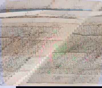
1893 Civil War Map of Northern Virginia -- Sheet 2. Survey for Military Defenses Map of Northeastern
Similar Sale History
View More Items in Maps & Atlases![1893 Civil War Map of Washington and NE. Virginia -- Surveys for Military Defenses Map of: Title: 1893 Civil War Map of Washington and NE. Virginia -- Surveys for Military Defenses Map of Northeastern Virginia and Vicinity of Washington [Sheet 1 Plate VII] Cartographer: US War Department Ye](https://p1.liveauctioneers.com/5584/241996/125442504_1_x.jpg?height=310&quality=70&version=1648585952)
![1894 Cowles Civil War Map of Northern Virginia, Maryland, Delaware and Parts of West Virginia and: Title: 1894 Cowles Civil War Map of Northern Virginia, Maryland, Delaware and Parts of West Virginia and Pennsylvania -- General Topographical Map, Sheet I [Plate CXXXVI] Cartographer: C Cowles (compi](https://p1.liveauctioneers.com/5584/300803/160207035_1_x.jpg?height=310&quality=70&version=1693946338)
![1894 Cowles Civil War Map of Virginia and Parts of West: Title/Content of Map: 1894 Cowles Civil War Map of Virginia and Parts of West Virginia and Maryland -- General Topographical Map, Sheet II [Plate CXXXVII] Cartographer: C Cowles (compiled by) Year/Pla](https://p1.liveauctioneers.com/5584/171770/86526634_1_x.jpg?height=310&quality=70&version=1592950942)


Related Maps & Atlases


![Antique Map of Scotland: [Antique Map of Scotland] "A New and Correct Map of Scotland or North Britain. with all the Post and Military roads, divisions & ca. Drawn from the most approved surveys, Illustrated with many additio](https://p1.liveauctioneers.com/268/328386/176967773_1_x.jpg?height=310&quality=70&version=1714748870)

More Items in Maps & Atlases
View More


![[Maps] Martin Zeiler, Itinerarium Italiae, 1640: [Maps] Martin Zeiler, Itinerarium Italiae, 1640, Martini Zeilleri. Itinerarium Italiae Nov-Antiquae: oder, Raiss-Beschreibung durch Italien, Matthaus Merian, Frankfurt, 40 plates, most double-page, in](https://p1.liveauctioneers.com/188/326797/176317459_1_x.jpg?height=310&quality=70&version=1713847031)


![[Maps] Gio. Ant. Magnini, Italia, 1620: [Maps] Gio. Ant. Magnini, Italia, 1620, Giovanni Antonio Magnini. Italia, data in luce da Fabio suo figliuolo al Serenissimo Ferdinado Gonzaga Duca di Matoua edi Monserrato etc. Bologna, for Sebastian](https://p1.liveauctioneers.com/188/326797/176317457_1_x.jpg?height=310&quality=70&version=1713847031)


Recommended Transportation & Travel Collectibles
View More


Item Details
Description
This is a highly detailed map showing Union and Confederate troop movements, color-coded, around Ynortheastern Virginia, south of Washington in 1862. Great deal of topographical, river, lake, road, camp, settlement, etc detail is offered. Litho by J Bien & Co. From the Atlas to Accompany the Official Records of the Union and Confederate Armies. Drawn by both Union and Confederate engineers.
Reserve: $80.00
Shipping:
Your purchase is protected:
Photos, descriptions, and estimates were prepared with the utmost care by a fully certified expert and appraiser. All items in this sale are guaranteed authentic.
In the rare event that the item did not conform to the lot description in the sale, Jasper52 specialists are here to help. Buyers may return the item for a full refund provided you notify Jasper52 within 5 days of receiving the item.
Condition
Very Good. Slight toning. Marginal splits. Issued centerfold. Colored.
Buyer's Premium
- 15%
1893 Civil War Map of Northern Virginia -- Sheet 2. Survey for Military Defenses Map of Northeastern
Estimate $100 - $120
4 bidders are watching this item.
Shipping & Pickup Options
Item located in Ohio, US$18 shipping in the US
Payment
Accepts seamless payments through LiveAuctioneers
See More Items From This Jasper52 Seller

TOP