


Bahamas. San Salvador Crooked Rum Cay Mariguana ADMIRALTY chart 1892 (1919) map
Similar Sale History
View More Items in Maps & Atlases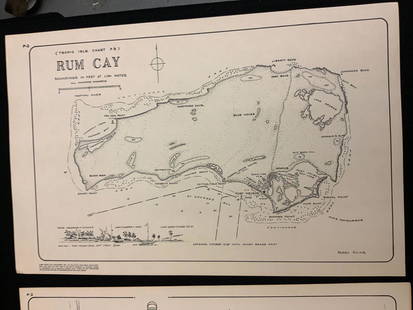


Related Maps & Atlases


![[MAP]. SARTINE, Antoine Plan de la Barre et du Havre de Charles-Town...1778. RARE REVOLUTIONARY WAR: [MAP]. SARTINE, Antoine (1729-1801). Plan de la Barre et du Havre de Charles-Town d'apres un plan Anglois leve en 1776... Paris: Depot de la Marine for M. de Sartine, 1778. Copperplate engraving, matt](https://p1.liveauctioneers.com/197/329395/177650540_1_x.jpg?height=310&quality=70&version=1715364962)


More Items in Maps & Atlases
View More

![[MAP]. TODESCHI, Pietro. [Nova et Acurata Totius Americae Tabula auct. G.I. Blaeu] America quarta: [MAP]. TODESCHI, Pietro. [Nova et Acurata Totius Americae Tabula auct. G.I. Blaeu] America quarta pars orbis quam plerunq, nuvum orbem appellitant primo detecta est anno 1492 a Christophoro Columbo...](https://p1.liveauctioneers.com/197/329395/177650542_1_x.jpg?height=310&quality=70&version=1715364962)


![[MAPS]. HOMANN, Johann Baptist, HOMANN HEIRS, and Georg Matthäus SEUTTER. [Composite Atlas].: [MAPS]. HOMANN, Johann Baptist (1663-1724), HOMANN HEIRS, and Georg Matthäus SEUTTER (1678-1757). [Composite Atlas]. [Nuremberg, Augsburg, and others: Homann Heirs and others, maps dated between](https://p1.liveauctioneers.com/197/329395/177650530_1_x.jpg?height=310&quality=70&version=1715364962)


![[MAP]. ORTELIUS, Abraham. Turcici Imperii Descriptio.1592.: [MAP]. ORTELIUS, Abraham (1527-1598). Turcici Imperii Descriptio. Antwerp, 1592. Engraved map with hand-coloring. Matted, framed, and double glazed, sight 406 x 521 mm (unexamined out of frame). Decor](https://p1.liveauctioneers.com/197/329395/177650538_1_x.jpg?height=310&quality=70&version=1715364962)
![[MAP]. ORTELIUS, Abraham. Americae Sive Novi Orbis, Nova Descriptio. 1573.: [MAP]. ORTELIUS, Abraham (1527-1598). Americae Sive Novi Orbis, Nova Descriptio. Antwerp, 1573. Engraved map with hand-coloring. Framed and double glazed, visible area 375 x 521 mm (unexamined out of](https://p1.liveauctioneers.com/197/329395/177650534_1_x.jpg?height=310&quality=70&version=1715364962)

![[MAP]. ORTELIUS, Abraham. Aevi Veteris, Typus Geographicus. 1601.: [MAP]. ORTELIUS, Abraham (1527-1598). Aevi Veteris, Typus Geographicus. Antwerp, 1601. Engraved map with hand-coloring. Matted, framed, and double glazed, visible area 343 x 470 mm (unexamined out of](https://p1.liveauctioneers.com/197/329395/177650532_1_x.jpg?height=310&quality=70&version=1715364962)
Recommended Transportation & Travel Collectibles
View More


![[FLAGS]. 31-star American parade flag. Ca 1850-1859.: [FLAGS]. 31-star American parade flag. Ca 1850-1859. 22 x 36 1/2 in. cotton flag with 31 printed stars, configured in a double medallion surrounding a much larger central star, that is haloed in both](https://p1.liveauctioneers.com/197/329785/177758218_1_x.jpg?height=310&quality=70&version=1715625218)


Item Details
Description
TITLE/CONTENT OF MAP: 'Atlantic Ocean - West Indies - Ports and Anchorages in the Bahamas // San Salvador or Watling Island // Anchorage on S.W. Side of Acklin Island // Crooked Island Anchorages // Rum Cay - Port Nelson // Crooked Island - Anchorage // Mariguana Island'
DATE PRINTED: Surveyed 1832-1886. Published 1892. Corrections to 1919
IMAGE SIZE: Approx 70.0 x 50.0cm, 27.5 x 19.75 inches (Large); Please note that this is a folding map.
TYPE: Large British nautical sea chart. Sea charts such as this were working navigational aids which were commonly updated and corrected during their working lives by hand annotation and/or printed overlays. They may also feature manuscript navigational notes, comments or other markings
CONDITION: Good; suitable for framing. However, please note: Spot. Light toning along right hand edge. Please check the scan for any blemishes prior to making your purchase. Please contact us if you would like to arrange to view this map. Virtually all antiquarian maps and prints are subject to some normal aging due to use and time which is not obtrusive unless otherwise stated. We offer a no questions asked return policy.
AUTHENTICITY: This is an authentic historic map, published at the date stated above. It is not a modern copy.
VERSO: There is nothing printed on the reverse side, which is plain
FOLDING: This is a folding map.
ARTIST/CARTOGRAPHER/ENGRAVER: Chiefly from surveys by Commander R. Owen, H.M.S. "Blossom," 1832. Port Nelson by the Officers of the U.S. Steamer "Albatross" 1886
PROVENANCE: London. Published at the Admiralty under the Superintendence of Captain W.J.L. Wharton, R.N., F.R.S, Hydrographer. Crown Copyright reserved
Reserve: $267.00
Shipping:Domestic: Flat-rate of $30.00 to anywhere within the contiguous U.S. International: Foreign shipping rates are determined by destination. International shipping may be subject to VAT. Combined shipping: Please ask about combined shipping for multiple lots before bidding. Location: This item ships from the United Kingdom
Your purchase is protected:
Photos, descriptions, and estimates were prepared with the utmost care by a fully certified expert and appraiser. All items in this sale are guaranteed authentic.
In the rare event that the item did not conform to the lot description in the sale, Jasper52 specialists are here to help. Buyers may return the item for a full refund provided you notify Jasper52 within 5 days of receiving the item.
DATE PRINTED: Surveyed 1832-1886. Published 1892. Corrections to 1919
IMAGE SIZE: Approx 70.0 x 50.0cm, 27.5 x 19.75 inches (Large); Please note that this is a folding map.
TYPE: Large British nautical sea chart. Sea charts such as this were working navigational aids which were commonly updated and corrected during their working lives by hand annotation and/or printed overlays. They may also feature manuscript navigational notes, comments or other markings
CONDITION: Good; suitable for framing. However, please note: Spot. Light toning along right hand edge. Please check the scan for any blemishes prior to making your purchase. Please contact us if you would like to arrange to view this map. Virtually all antiquarian maps and prints are subject to some normal aging due to use and time which is not obtrusive unless otherwise stated. We offer a no questions asked return policy.
AUTHENTICITY: This is an authentic historic map, published at the date stated above. It is not a modern copy.
VERSO: There is nothing printed on the reverse side, which is plain
FOLDING: This is a folding map.
ARTIST/CARTOGRAPHER/ENGRAVER: Chiefly from surveys by Commander R. Owen, H.M.S. "Blossom," 1832. Port Nelson by the Officers of the U.S. Steamer "Albatross" 1886
PROVENANCE: London. Published at the Admiralty under the Superintendence of Captain W.J.L. Wharton, R.N., F.R.S, Hydrographer. Crown Copyright reserved
Reserve: $267.00
Shipping:
Your purchase is protected:
Photos, descriptions, and estimates were prepared with the utmost care by a fully certified expert and appraiser. All items in this sale are guaranteed authentic.
In the rare event that the item did not conform to the lot description in the sale, Jasper52 specialists are here to help. Buyers may return the item for a full refund provided you notify Jasper52 within 5 days of receiving the item.
Buyer's Premium
- 15%
Bahamas. San Salvador Crooked Rum Cay Mariguana ADMIRALTY chart 1892 (1919) map
Estimate $300 - $350
Get approved to bid.
Shipping & Pickup Options
Item located in United Kingdom$30 shipping in the US
Payment
Accepts seamless payments through LiveAuctioneers
See More Items From This Jasper52 Seller

TOP