
 Discovery- InteriorsBonhamsSponsored.Your ad here?


Discovery- Interiors
Bonhams
Sponsored.Your ad here?


 Discovery- InteriorsBonhamsSponsored.Your ad here?


Discovery- Interiors
Bonhams
Sponsored.Your ad here?

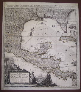
Laurie & Whittle Map of the Southern British Colonies of America
Similar Sale History
View More Items in Maps & AtlasesRelated Maps & Atlases
More Items in British Maps & Atlases
View MoreRecommended Transportation & Travel Collectibles
View More


Item Details
Description
LAURIE, Robert (1755-1836), and WHITTLE, James (1757-1818).
A New and General Map of the Southern Dominions belonging to the United States of America...
Engraved map with original hand color in outline.
London: Laurie & Whittle, 1794.
21 1/4" x 28 3/4" sheet.
This is the second edition of this important map that was first published in 1776 in a British military atlas. In this edition the title has been revised to acknowledge the United States. The map is based on the work of De Brahm, Collet, Mouzon and the important hydrographical surveys of the coast of Florida and the Bahamas by Bernard Romans. It includes inset plans of St. Augustine and Charleston above the decorative title cartouche. The map is most noteworthy for its depiction of East and West Florida.
Buyer's Premium
- 25%
Laurie & Whittle Map of the Southern British Colonies of America
Estimate $1,800 - $3,200
8 bidders are watching this item.
Shipping & Pickup Options
Item located in New York, NY, usOffers In-House Shipping
Local Pickup Available
Payment
Accepts seamless payments through LiveAuctioneers

Related Searches
TOP


![Des Barres Map of NY Harbor: *** START PRICE IS THE RESERVE *** [America] DES BARRES, Joseph Frederick Wallet (1729-1824). A Chart of New York Harbour with the Soundings Views of Land Marks and Nautical directions for the Use of](https://p1.liveauctioneers.com/1968/163248/82424572_1_x.jpg?height=310&quality=70&version=1583340284)


