


 Discovery- InteriorsBonhamsSponsored.Your ad here?


Discovery- InteriorsBonhamsSponsored.Your ad here?

The État Major Maps of France - the larger and more detailed successor to Cassini
Similar Sale History
View More Items in Maps & Atlases


![France.- Ortelius (Abraham) Four sheets with seven maps: NO RESERVE France.- Ortelius (Abraham) Four sheets with seven maps of France, including the Artois region of north eastern France [Atrebatum Regionis...], Calais and Boulogne [Caletensium et Bononiens](https://p1.liveauctioneers.com/5458/236692/122702398_1_x.jpg?height=310&quality=70&version=1644332470)

Related Maps & Atlases


More Items in Maps & Atlases
View More


![[Maps] Gio. Ant. Magnini, Italia, 1620: [Maps] Gio. Ant. Magnini, Italia, 1620, Giovanni Antonio Magnini. Italia, data in luce da Fabio suo figliuolo al Serenissimo Ferdinado Gonzaga Duca di Matoua edi Monserrato etc. Bologna, for Sebastian](https://p1.liveauctioneers.com/188/326797/176317457_1_x.jpg?height=310&quality=70&version=1713847031)
Recommended Transportation & Travel Collectibles
View More


Item Details
Description
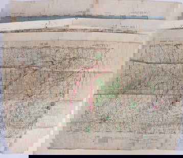
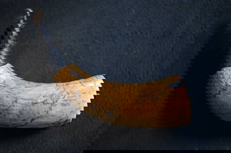
LES OFFICERS DE L'ÉTAT MAJOR, engraved at the DÉPOT DE GUERRE, under the direction of LIEUTENANT GENERAL PELET. France Dressée par l'État-Major. Paris: Dépot de Guerre, 1832-1876. The set comprises 34 uniform contemporary stiff card boxes with pull-off tops, marbled paper exteriors, pink or blue paper interiors, and tan imitation-calf paper labels, lettered and ruled in gilt. Boxes measure 8 1/4 tall x 3 wide x 5 inches (21.25 x 8 x 13 cm.); with 266 (out of a total of 273, per the boxes' labels) numbered engraved folding maps dissected in twenty-one panels, and with the unnumbered hand-colored smaller-sized key map; all maps are linen-backed, with a parchment tab numbered in manuscript, and with printed and manuscript paper labels, the printed labels are from four Parisian map retailers, Simonneau, Longuet, Lanée, and Lemière, many of the maps blind-stamped by the Dépot de Guerre, some blind-stamped by their retailers. The numbered maps' sizes vary slightly, but measure around 23 x 33 inches (59 x 85 cm). General toning and wear to boxes, with some rubbing and chipping to paper labels, a few short splits and cracks at corners, crude tape repairs to some of the boxes including 3, 6, 7, 9, 23, 33, and 34, box 12 lacking its bottom, front panel of the lid of box 28 cracked and defective but tape repaired, the maps with intermittent light foxing and offsetting, a few of the parchment tabs missing, the set is lacking maps 179 Bis (Bonneval), 213 Bis (Saorge), 225 (Nice), 225 Bis (Pont St Louis), 261 (Bastia), 263 (Corte), and 265 (Bastelica), sold as is.
A rare, early, and nearly complete set of Carte de France de l'État Major, attractively housed in thirty-four contemporary marbled paper boxes. This was the clear successor to the Cassini family's earlier mapping project, the Carte de France, which was the first scientific survey of the country. The Cassinis' maps (published from 1678 to 1815) had taken so long to produce that, by the time the project was finished, it was already long out of date. As such, Charles X issued a royal ordinance in 1827 allowing the Dépot de Guerre to begin work on this new project, which was published between 1832 and 1876. The État Major improves on the Cassini family's practice of scientific surveying by using the most up-to-date technologies and methods available for astronomical and trigonometrical observation, allowing for a more extensive, accurate, and detailed set of maps. The major changes result from the État Major being mapped on a scale of 1:80,000, and including a wealth of new information, both administrative, as well as topographical. It even shows certain buildings such as churches (the church towers that were used as triangulation points are separately marked), various freestanding buildings, windmills, post houses, and more. Some of the most striking maps show, with an incredible amount of detail, the topography of the Alps and its glaciers, and the maps also include forests, swamps, salt marshes, agricultural fields, and vineyards. The maps of metropolitan France were completed by around 1868, but certain additions were added later. This set of the Carte de France de l'État Major includes many of the additional maps published between 1870 and 1876 (though some of these are, unfortunately, lacking). These final maps show the Alps along the Swiss and Italian borders, the Comté de Nice, and the Mediterranean island of Corsica. A later edition of État Major maps was published in 1889, and more editions appeared throughout the twentieth century, with the most recent being the 1972 edition.
Condition
Request a condition report
Buyer's Premium
- 33% up to $50,000.00
- 32% up to $1,000,000.00
- 26% above $1,000,000.00
The État Major Maps of France - the larger and more detailed successor to Cassini
Shipping & Pickup Options
Item located in New York, NY, usPayment

Auction Curated By
