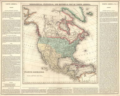
Carey and Lea, Geographical, Statistical, and
Similar Sale History
Recommended Items


Item Details
Description
CAREY & LEA. Geographical, Statistical, and Historical Map of Rhode Island. Philadelphia: H. C. Carey & I. Lea, 1827. Originally published in “A Complete Historical, Chronological, and Geographical American Atlas.” Engraved, original hand color in full. Sheet size: 17 ¾ x 21 ¾ inches. Neat line to neat line: 11 ¼ x 8 ½ inches. Along with his brother-in-law, Isaac Lea, “Carey & Lea” became one of the most prominent publishing houses in the country. A Complete Historical, Chronological, and Geographical American Atlas was comprised of maps surrounded by text documenting the history, climate, population and other specifications of each area. Carey & Lea’s approach to this publication focused on the western hemisphere as a region with the potential for wealth, opportunity and development. Works from this atlas are known as some of the finest examples of early depictions of the United States.
Buyer's Premium
- 25%
Carey and Lea, Geographical, Statistical, and
Estimate $100 - $200
Get approved to bid.
Shipping & Pickup Options
Item located in New York, NY, usSee Policy for Shipping
Payment

Related Searches
TOP


![[Provenance, Hamilton Fish, Fanny Kemble]: Butler, Frances Anne (Fanny Kemble.) JOURNAL. Philadelphia: Carey, Lea and Blanchard, 1835. 12mo, 2 vols. [4], [13]-252, [12, ads]; 218, [36, ads] pp. First American edition. With half-titles. Mismatc](https://p1.liveauctioneers.com/3532/326332/175680418_1_x.jpg?height=310&quality=70&version=1713150771)


