


 Discovery- InteriorsBonhamsSponsored.Your ad here?
Discovery- Interiors
Bonhams
Sponsored.Your ad here?


Discovery- InteriorsBonhamsSponsored.Your ad here?
Discovery- Interiors
Bonhams
Sponsored.Your ad here?

VINTAGE EUROPEAN PRINTED MAPS FOUR
Similar Sale History
View More Items in Maps & Atlases


![Colorado Historic Maps [153133]: Four different vintage travel maps of Colorado.A) Blazed Trails in Colorado, Compliments of Continental Oil Co., Denver, Colorado. Approx. 24 x 21 inches when unfolded. B) Classon's Colorado Green Gui](https://p1.liveauctioneers.com/2699/258185/134287643_1_x.jpg?height=310&quality=70&version=1660347389)


Related Maps & Atlases


More Items in Maps & Atlases
View More


![[Maps] Gio. Ant. Magnini, Italia, 1620: [Maps] Gio. Ant. Magnini, Italia, 1620, Giovanni Antonio Magnini. Italia, data in luce da Fabio suo figliuolo al Serenissimo Ferdinado Gonzaga Duca di Matoua edi Monserrato etc. Bologna, for Sebastian](https://p1.liveauctioneers.com/188/326797/176317457_1_x.jpg?height=310&quality=70&version=1713847031)

Recommended Transportation & Travel Collectibles
View More


Item Details
Description
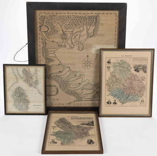
VINTAGE EUROPEAN PRINTED MAPS, FOUR, H 4 1/2"-13 3/4" W 6 1/4"-12 1/2":Including one map of St. Lucia, published by J. Gold, June 30th, 1806, London, measuring H. 4 1/2" x 6 1/4"; together with one map of Turkey: Central Mediterranean Regions, The Grecian Archipelago, according to the English Admiralty survey, drawn Augustus Petermann, and engraved by G.H. Swanston, at H. 11" x 12 1/2", and one map of Ireland, drawn and engraved by J. Rapkin, published by J & F Tallis, London, Edinburgh & Dublin, at H. 13 3/4" x 9 1/4", both feature scenes at either side. The grouping also includes one map of Paris as it was on the advent of Philip Augustus in 1180, measuring H. 7 5/8" x 10 1/4". Each map is matted and framed under glass.
Condition
Several show areas of toning to the paper and light creasing, otherwise condition appears to be good. Ln
Buyer's Premium
- 23%
VINTAGE EUROPEAN PRINTED MAPS FOUR
Estimate $50 - $100
1 bidder is watching this item.
Shipping & Pickup Options
Item located in Detroit, MI, usSee Policy for Shipping
Payment

Related Searches
TOP