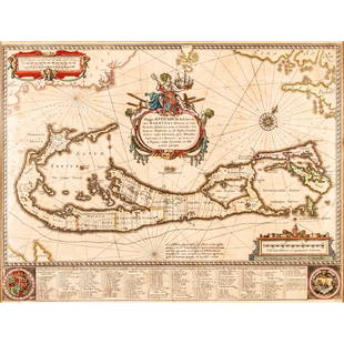
Mappa Aestivarum Insularum... [ca. 1720]
Similar Sale History
View More Items in Maps & Atlases
Related Maps & Atlases
More Items in Maps & Atlases
View MoreRecommended Transportation & Travel Collectibles
View More


![Mappa Aestivarum Insularum... [ca. 1720]](https://p1.liveauctioneers.com/179/85723/44107982_1_x.jpg?quality=1&version=1457208330&width=486)
![Mappa Aestivarum Insularum... [ca. 1720]](https://p1.liveauctioneers.com/179/85723/44107982_1_x.jpg?quality=80&version=1457208330)
Item Details
Description
[New World/Bermudan Plats]. MAPPA AESTIVARUM INSULARUM, ALIAS BARMUDAS DICTARUM, AD OSTIA MEXICANI… Amst: P. Schenk and G. Valk, (nd), [ca. 1720]. Outer edge of map’s border: 13 ¼” x 20 ¼”. With key and 2 armorial symbols: 15 ¼ x 20 ¼”. Attractive double page map of land holdings on the island of Bermuda. Names of tribes also appear on the map. Oriented to the northeast. At the upper left corner of the map is a vaguely drawn landmass labeled “Virginia” and Florida,” and at the upper right is a piece of land labeled “Nova Anglia” and “New England.” The map was engraved with a plate previously used by John Speed (ca. 1627-31), Blaeu (ca. 1630’s), Hondius [ca. early 1640’s], and Jannson [ca. 1645-47], with each mapmaker substituting his own name under the scale at lower right. Later hand-coloring. Hinging bits at top of verso. Very good. Ink notation in margin at upper right.
Buyer's Premium
- 25%
Mappa Aestivarum Insularum... [ca. 1720]
Estimate $400 - $600
2 bidders are watching this item.
Shipping & Pickup Options
Item located in Falls Church, VA, usSee Policy for Shipping
Payment

Related Searches
TOP


![[MAP OF BERMUDA] BLAEU, WILLEM (c. 1630): Mappa Aestivarum Insularum, alias Barmudas..., engraved bi-fold map with hand-coloring, showing the coasts of Florida, Viginia, Cape Cod, and New England, based on Speed's map, with latin text on vers](https://p1.liveauctioneers.com/522/152734/77123885_1_x.jpg?height=310&quality=70&version=1571345617)


![Nevada City, CA Map, etc. c1930s-50s (3) [180880]: This Nevada City, CA, collection of three includes a 22" x 17.5" rare caricature map of Nevada City, c1950s. The lot also includes letterhead (3) from Schreiber's CafÈ in Nevada City, Ernest Schreibe](https://p1.liveauctioneers.com/2699/331495/178785751_1_x.jpg?height=310&quality=70&version=1717094933)

![[MAP]. SPEED, John. A New Mappe of the Romane Empire. 1676.: [MAP]. SPEED, John (ca 1551-1629). A New Mappe of the Romane Empire. London: Basset & Chiswell, 1676. Engraved map with hand-coloring. Framed and double glazed, sight 419 x 559 mm. Decorative cartouch](https://p1.liveauctioneers.com/197/329395/177650541_1_x.jpg?height=310&quality=70&version=1715364962)


![[Maps & Atlases] (Merian, M(athaus).: Constantinopolis: [Maps & Atlases] (Merian, M(athaus).: Constantinopolis Merian, M(athaus). Constantinopolis (Frankfurt, ca. 1650). Engraved hand-colored panoramic view, 12 7/8 x 28 3/4 in. (327 x 730 mm). Creasing fro](https://p1.liveauctioneers.com/65/332523/179335171_1_x.jpg?height=310&quality=70&version=1717622830)
![[Maps & Atlases] Seutter, Matth(ias).: Novus Orbis sive America...: [Maps & Atlases] Seutter, Matth(ias).: Novus Orbis sive America... Seutter, Matth(ias). Novus Orbis sive America Meridionalis et Septentrionalis… Augsburg, ca. 1730. Engraved hand-colored map of](https://p1.liveauctioneers.com/65/332523/179335174_1_x.jpg?height=310&quality=70&version=1717622830)


![[MAPS]. HOMANN, Johann Baptist, HOMANN HEIRS, and Georg Matthäus SEUTTER. [Composite Atlas].: [MAPS]. HOMANN, Johann Baptist (1663-1724), HOMANN HEIRS, and Georg Matthäus SEUTTER (1678-1757). [Composite Atlas]. [Nuremberg, Augsburg, and others: Homann Heirs and others, maps dated between](https://p1.liveauctioneers.com/197/329395/177650530_1_x.jpg?height=310&quality=70&version=1715364962)
![[MAP]. TODESCHI, Pietro. [Nova et Acurata Totius Americae Tabula auct. G.I. Blaeu] America quarta: [MAP]. TODESCHI, Pietro. [Nova et Acurata Totius Americae Tabula auct. G.I. Blaeu] America quarta pars orbis quam plerunq, nuvum orbem appellitant primo detecta est anno 1492 a Christophoro Columbo...](https://p1.liveauctioneers.com/197/329395/177650542_1_x.jpg?height=310&quality=70&version=1715364962)
![[MAP]. ORTELIUS, Abraham. Americae Sive Novi Orbis, Nova Descriptio. 1573.: [MAP]. ORTELIUS, Abraham (1527-1598). Americae Sive Novi Orbis, Nova Descriptio. Antwerp, 1573. Engraved map with hand-coloring. Framed and double glazed, visible area 375 x 521 mm (unexamined out of](https://p1.liveauctioneers.com/197/329395/177650534_1_x.jpg?height=310&quality=70&version=1715364962)


![[MAP]. ORTELIUS, Abraham. Turcici Imperii Descriptio.1592.: [MAP]. ORTELIUS, Abraham (1527-1598). Turcici Imperii Descriptio. Antwerp, 1592. Engraved map with hand-coloring. Matted, framed, and double glazed, sight 406 x 521 mm (unexamined out of frame). Decor](https://p1.liveauctioneers.com/197/329395/177650538_1_x.jpg?height=310&quality=70&version=1715364962)
![Set of Twelve Satirical Anthropomorphic Maps of Europe: [SATIRICAL MAPS] A set of twelve satirical anthropomorphic maps of Europe. London: circa 1868. A set of 12 (believed complete) lithographed maps by Vincent Brooks, Day & Son, London, each offering](https://p1.liveauctioneers.com/292/330597/178279264_1_x.jpg?height=310&quality=70&version=1716409282)


![Sanitary & Topographical "Viele Map" of Manhattan 1865 [182838]: Manhattan Island map surveyed by Mexican American & Civil War veteran Egbert Viele 1865. Viele was author of a color city map, a "Sanitary & Topographical Map of the City and Island of New York," firs](https://p1.liveauctioneers.com/2699/331495/178785766_1_x.jpg?height=310&quality=70&version=1717094933)
![[MAP]. ORTELIUS, Abraham. Romani Imperii Imago. 1592.: [MAP]. ORTELIUS, Abraham (1527-1598). Romani Imperii Imago. Antwerp, 1592. Engraved map with hand-coloring. Matted, framed, and double glazed, visible area 381 x 521 mm (unexamined out of frame). 6 de](https://p1.liveauctioneers.com/197/329395/177650537_1_x.jpg?height=310&quality=70&version=1715364962)


