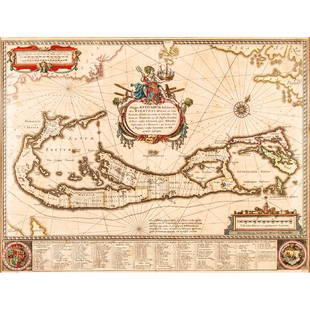
1654 Mappa Aestivarum Insularum, alias Barmudas
Similar Sale History
View More Items in Maps & Atlases
Related Maps & Atlases
More Items in Maps & Atlases
View MoreRecommended Transportation & Travel Collectibles
View More


Item Details
Description
By: Jan JanssonDate: 1654 (published) AmsterdamDimensions: 15.5 x 20.5 inches (39.4 x 52 cm)This is an authentic antique map of Bermuda by Jan Jansson. The map was published out of Amsterdam circa 1654.Based on Richard Norwood's 1618 map, the engraving actually includes two maps of Bermuda: besides the large depiction of Bermuda, is another small depiction of Bermuda ("Bermudas Insul, alias Sommer Island") in the center of the map. It relates in scale to the upper border of the map showing Cape Cod, Nova Scotia and Virginia.The map is color coded into eight equally sized tribes, later called parishes. These were named for shareholders in the Company, and were further divided (by tribe roads) into lots which equated to shares in the Company. The Company's return on investment came specifically from cash crops raised on that land. A key at the bottom of the map notes the each family name, their specific lot, and the total number of shares they owned.Condition: Map is in B condition, faint color, a few short marginal tears and an extensive centerfold separation the have repaired on verso, some light browning.
Condition
Included in Description.
Weight
0.5 lb
Buyer's Premium
- 25% up to $500,000.00
- 25% above $500,000.00
1654 Mappa Aestivarum Insularum, alias Barmudas
Estimate $750 - $1,000
9 bidders are watching this item.
Shipping & Pickup Options
Item located in Chicago, IL, us$10 shipping in the US
Payment

Related Searches
TOP


![[MAP OF BERMUDA] BLAEU, WILLEM (c. 1630): Mappa Aestivarum Insularum, alias Barmudas..., engraved bi-fold map with hand-coloring, showing the coasts of Florida, Viginia, Cape Cod, and New England, based on Speed's map, with latin text on vers](https://p1.liveauctioneers.com/522/152734/77123885_1_x.jpg?height=310&quality=70&version=1571345617)


![[Maps] Gio. Ant. Magnini, Italia, 1620: [Maps] Gio. Ant. Magnini, Italia, 1620, Giovanni Antonio Magnini. Italia, data in luce da Fabio suo figliuolo al Serenissimo Ferdinado Gonzaga Duca di Matoua edi Monserrato etc. Bologna, for Sebastian](https://p1.liveauctioneers.com/188/326797/176317457_1_x.jpg?height=310&quality=70&version=1713847031)
![[Maps] Martin Zeiler, Itinerarium Italiae, 1640: [Maps] Martin Zeiler, Itinerarium Italiae, 1640, Martini Zeilleri. Itinerarium Italiae Nov-Antiquae: oder, Raiss-Beschreibung durch Italien, Matthaus Merian, Frankfurt, 40 plates, most double-page, in](https://p1.liveauctioneers.com/188/326797/176317459_1_x.jpg?height=310&quality=70&version=1713847031)


